Shire of Wongan-Ballidu
| Shire of Wongan-Ballidu Western Australia | |||||||||||||||
|---|---|---|---|---|---|---|---|---|---|---|---|---|---|---|---|
 Ballidu Hall, 2014 | |||||||||||||||
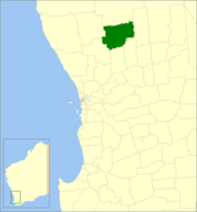 Location in Western Australia | |||||||||||||||
| Population | 1,586 (2013 est)[1] | ||||||||||||||
| • Density | 0.47080/km2 (1.2194/sq mi) | ||||||||||||||
| Established | 1887 | ||||||||||||||
| Area | 3,368.7 km2 (1,300.7 sq mi) | ||||||||||||||
| Mayor | Peter Macnamara | ||||||||||||||
| Council seat | Wongan Hills | ||||||||||||||
| Region | Wheatbelt | ||||||||||||||
| State electorate(s) | Central Wheatbelt | ||||||||||||||
| Federal Division(s) | Durack | ||||||||||||||
|
| |||||||||||||||
| Website | Shire of Wongan-Ballidu | ||||||||||||||
| |||||||||||||||
The Shire of Wongan-Ballidu is a local government area in the Wheatbelt region of Western Australia, about 180 kilometres (112 mi) NNE of Perth, the state capital. The Shire covers an area of 3,369 square kilometres (1,301 sq mi) and its seat of government is the town of Wongan Hills.
History
On 10 February 1887, the Melbourne Road District was created. It was renamed Wongan-Ballidu on 18 June 1926. On 1 July 1961, it became a shire under the Local Government Act 1960.[2]
Wards
As of 3 May 2003, there are ten councillors and no wards. The mayor is directly elected.
Towns and localities
Population
| Year | Population |
|---|---|
| 1921 | 666 |
| 1933 | 1,582 |
| 1947 | 1,530 |
| 1954 | 2,048 |
| 1961 | 2,145 |
| 1966 | 2,333 |
| 1971 | 2,243 |
| 1976 | 2,177 |
| 1981 | 2,087 |
| 1986 | 1,922 |
| 1991 | 1,685 |
| 1996 | 1,538 |
| 2001 | 1,503 |
| 2006 | 1,385 |
References
- ↑ "3218.0 Regional Population Growth, Australia. Table 5. Estimated Resident Population, Local Government Areas, Western Australia". 3 April 2014. Retrieved 11 September 2014.
- ↑ WA Electoral Commission, Municipality Boundary Amendments Register (release 3.0), 31 July 2007.
External links
![]()
This article is issued from
Wikipedia.
The text is licensed under Creative Commons - Attribution - Sharealike.
Additional terms may apply for the media files.