City of Armadale
| City of Armadale Western Australia | |||||||||||||||
|---|---|---|---|---|---|---|---|---|---|---|---|---|---|---|---|
 | |||||||||||||||
| Population | 79,602 (2016 census)[1] | ||||||||||||||
| • Density | 142.273/km2 (368.49/sq mi) | ||||||||||||||
| Established | 1894 | ||||||||||||||
| Area | 559.5 km2 (216.0 sq mi) | ||||||||||||||
| Mayor | Henry Zelones | ||||||||||||||
| Council seat | Armadale | ||||||||||||||
| Region | South East Metropolitan Perth; Darling Scarp | ||||||||||||||
| State electorate(s) | Armadale, Darling Range, Southern River | ||||||||||||||
| Federal Division(s) | Burt, Canning | ||||||||||||||
 | |||||||||||||||
| Website | City of Armadale | ||||||||||||||
| |||||||||||||||
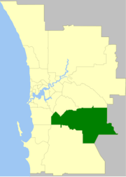
The City of Armadale is a local government area in the south-eastern suburbs of the Western Australian capital city of Perth, about 28 kilometres (17.4 mi) southeast of Perth's central business district. The City covers an area of 560 square kilometres (216 sq mi), much of which is state forest rising into the Darling Scarp to the east, and had a population of almost 80,000 as at the 2016 Census.
History
Prior to European settlement, the area now known as the City of Armadale was part of the land that was occupied by the Aboriginal Noongar people.[2]
Prior to 1894, the area was part of the Canning Road District.
The Kelmscott Road District was created on 14 December 1894 out of parts of Fremantle and Jandakot Road Districts. On 24 March 1910, it was renamed Armadale-Kelmscott.[3]
On 1 July 1961, it became the Shire of Armadale-Kelmscott following the enactment of the Local Government Act 1960. On 1 July 1977, its Byford Ward was abolished and transferred to the Shire of Serpentine-Jarrahdale.[4]
On 1 July 1979 it became the Town of Armadale and on 16 November 1985 it attained city status.[3]
The City of Armadale maintains 615 km of roads and a little over 14 km² of parks and gardens.
Mayors
Wards
The city has been divided into seven wards, each with two councillors. The mayor is elected from among the councillors.
- Heron Ward
- Lake Ward
- Jarrah Ward
- Minnawarra Ward
- Neerigen Ward
- Palomino Ward
- River Ward
Suburbs
Population
| Historical population | |||||||||||||||||||||||||||||||||||||||||||||||||||||||
|---|---|---|---|---|---|---|---|---|---|---|---|---|---|---|---|---|---|---|---|---|---|---|---|---|---|---|---|---|---|---|---|---|---|---|---|---|---|---|---|---|---|---|---|---|---|---|---|---|---|---|---|---|---|---|---|
|
| ||||||||||||||||||||||||||||||||||||||||||||||||||||||
- Note: The 1976 figure above, reported from the 1978 year book and 1981 census, is the figure after the removal of 1,634 residents living in Byford and nearby areas, which occurred in 1977.
References
- ↑ Australian Bureau of Statistics (27 June 2017). "Armadale (C)". 2016 Census QuickStats. Retrieved 26 November 2017.

- ↑ "Archived copy". Archived from the original on 2013-02-19. Retrieved 2013-01-10.
- 1 2 WA Electoral Commission, Municipality Boundary Amendments Register (release 3.0), 31 July 2007.
- ↑ "Local Government Act, 1960-1976 - Order in Council (per LG. AK/4/2)". Western Australia Government Gazette. 17 June 1977. p. 1977:1821.
External links
Elector Information - http://www.banned.oestex.com
Coordinates: 32°9′11″S 116°0′54″E / 32.15306°S 116.01500°E