York, Western Australia
| York Western Australia | |||||||||
|---|---|---|---|---|---|---|---|---|---|
 | |||||||||
 York | |||||||||
| Coordinates | 31°53′18″S 116°46′07″E / 31.88833°S 116.76861°ECoordinates: 31°53′18″S 116°46′07″E / 31.88833°S 116.76861°E | ||||||||
| Population | 2,387 (2011 census)[1] | ||||||||
| Established | 1835[2][3] | ||||||||
| Postcode(s) | 6302 | ||||||||
| Elevation | 179 m (587 ft) | ||||||||
| Location | 96 km (60 mi) E of Perth | ||||||||
| LGA(s) | Shire of York | ||||||||
| State electorate(s) | Central Wheatbelt | ||||||||
| Federal Division(s) | Pearce | ||||||||
| |||||||||
York is the oldest inland town in Western Australia, situated on the Avon River, 97 kilometres (60 mi) east of Perth, and is the seat of the Shire of York.
The York district took its name from Yorkshire because of its valleys.[4]
The area was first settled in 1831, two years after Perth was settled in 1829. A town was established in 1835 with the release of town allotments and the first buildings were erected in 1836.
The region was important throughout the 19th century for sheep and grain farming, sandalwood, and horse breeding.
York boomed during the gold rush as it was one of the last rail stops before the walk to the goldfields.
Today, the town attracts tourists for its beauty, history, buildings, festivals and art.
History
With the increasing population of the Swan River Settlement in 1830, it became evident that suitable land would have to be discovered for the growing of crops needed to provide necessary food.
Ensign Robert Dale, a 20-year-old officer of the 63rd Regiment, led a small party in the first exploratory journey over the Darling Range, during the winter months of 1830 into what was later to be known as the Avon Valley.[5][6]
He returned with a report of "park-like lands with scattered trees", and after a second expedition, Lieutenant-Governor Stirling concluded that there appeared to be 1,000 square miles of "the finest imaginable sheep-land".[7]
As a result, Stirling decided that the new district should be thrown open for selection and this was done by Government Notice on 11 November 1830.[8] By December 1830, 250,000 acres had been allotted, and in January 1831, 80,000 acres. Before the end of 1831 a further 6,030 acres in small lots had been taken up.[9]
In September 1831 Dale escorted the first party of settlers to the district, reaching the Avon valley on 16 September. They immediately set about the construction of huts, the preparation required for their stock and the cultivation of new land. Dale proposed an area two miles south of the summit of Mt Bakewell as the site for a future town to serve the district.[10]
In September 1833 a garrison of eight troops of the 21st North British Fusiliers was stationed at York.[11][12] Rules and regulations for the assignment of town allotments at York were gazetted in September 1834 and allotments were advertised for sale from July 1835.[2][13]
A township did not begin to appear until 1836. In July 1836 York comprised two houses, a barn, an army barracks and some out-houses, with about 50 acres of cleared land.[9]
In 1834, Revett Henry Bland settled in York as the Resident Magistrate and purchased a 50 acre block of land south of the town site, and a larger block which he established as a farm called Balladong, after the Ballardong Noongar, the Aboriginal occupiers of the area. This area became to be called Bland's Town or Bland Town.[14]
In 1836, John Henry Monger Snr arrived and bought land immediately north of the town site from Bland and his business partner, Arthur Trimmer for £100[15]. He had constructed a hotel of wattle and daub by early 1837,[16] constructing in 1842[17] a "long, low building" opposite the hotel for a store,[18] and “every three months his wagons would journey to Guildford or Perth for supplies”.[19]
In 1840, the York Agricultural Society was established,[20] which became very influential in the following years, holding annual shows to the present day. The York Racing Club was established in 1843. Both societies continue today.
A shortage of labour was a problem for the farming community, particularly at harvest time.[21] A sandalwood boom in the late 1840s lifted the town.[22]
At the request of the influential York Agricultural Society, from 1851, convicts were transported to the Colony and relieved the labour shortages. As "ticket-of-leave" men, they constructed many of the early buildings.[lower-alpha 1]
Solomon Cook constructed a steam engine in 1852 to power his flourmill and this started a flourish of steam-powered flour mills in the town.[23]
York was connected by rail in 1885. Following the discovery of gold in the Yilgarn in 1887, the town was teeming with miners, all alighting from the train and preparing to make the long journey across the plains to the goldfields.

Heritage buildings and sites
For a town of its size, there are more heritage buildings in York than in any other town in Western Australia. not only that, the entire town has been declared a "Historic Town" by the National Trust of Australia. The streets of York are lined with buildings both big and small that evoke the essence of the nineteenth century. The main street, Avon Terrace, remains almost exactly as it was in 1911, the year that the spectacular Town Hall was constructed. But behind the main street lie a wealth of historic houses and cottages and places of interest each with its own story and of the generation of people who lived in them.[25]
With its hamlet Bland's Town, York has buildings from each decade from the early settlers (1830s and 1840s), the convict period (1850s and 1860s), the coming of rail (1885), the Gold Rush (1887 to 1900), and the Federation boom, culminating in the York Town Hall (1911).
Faversham House, overlooking the north end of Avon Terrace, is one of the grandest surviving Colonial homes in the State.
More than 200 buildings or sites in York are heritage listed, most within the town itself. Many of York's older homes and buildings have now been restored and, while some have retained their original use (e.g. the York Post Office and the Westralia Bank building - now Westpac bank), others have been adaptively re-used with success, such as the old Primary School.
- Gallery of some Heritage Buildings in York
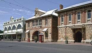 Co-op, York Post Office, Courthouse

 Sargent's Pharmacy
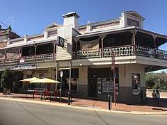 Davies Buildings
 York Palace Hotel
 Sisters of Mercy Convent
 Eliza's Cottage
Architecture
The centre of the town has fine examples of more than a dozen Victorian and Federation architectural styles, virtually uninterrupted by modern buildings. The Victorian Georgian style Resident Magistrate's House, one of the oldest houses in York (dating from the 1840s) now houses the Residency Museum. Other Victorian Georgian buildings are the old sections of Settlers Inn and the Castle Hotel.
The Convent School House (1872) is a Victorian Tudor building, the same style as many of Perth's early buildings and also probably designed by Richard Roach Jewell.[lower-alpha 2]
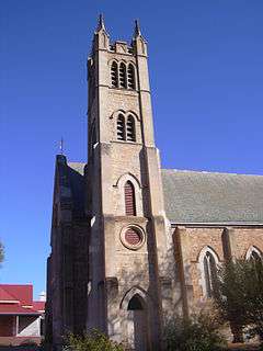
York churches include the Victorian Romanesque style Anglican Holy Trinity Church (completed in 1854), designed by Richard Roach Jewell; St Patrick's original church (1859-60); St Patrick's Church (designed in the Gothic Revival style by the former convict architect Joseph Nunan and completed in 1886); and the York Uniting Church constructed of local granite in the Gothic style (1888).
The Catholic Presbytery is in Victorian Rustic Gothic style.
The coming of rail in 1885 brought the Victorian Filigree style Imperial Hotel (1886).
Gold rush buildings include the Federation Warehouse style York Roller Flour Mill (1892), now a café and gallery, at the entrance to York and many of the buildings in Avon Terrace.
The Westralia Bank building, designed by JJ Talbot Hobbs and the Masonic Hall (designed by James William Wright), are in Victorian Academic Classical style.
Most of the main street, Avon Terrace, has Victorian or Federation Free Classical buildings, including the Co-op (IGA) (1888 façade), the Motor Museum, and Dinsdale's Shoe Emporium (1887), with a cluster of Federation Romanesque buildings at the north end, including the former Fire Station (1897).
Some of the most significant buildings in York are in Federation Arts and Crafts style (or its commercial equivalent, Federation Free Style). The 19th century Western Australia Government Architect, George Temple-Poole, a lover of Arts and Crafts style, designed six buildings: the railway station building (built in 1885); the York Post Office (1893); the Courthouse and police station (c. 1896);[27] the York Hospital (opened in 1896); and the old Primary School. All are on the State Heritage Register.[28]
Early 20th century buildings include the Federation Mannerist (or Edwardian Opulence) style Town Hall (designed by James William Wright of Wright, Powell and Cameron and built in 1911), and the Federation Filigree style Castle Hotel (1905), designed by William G Wolf, who designed His Majesty's Theatre.
- Gallery of some buildings in York of architectural interest
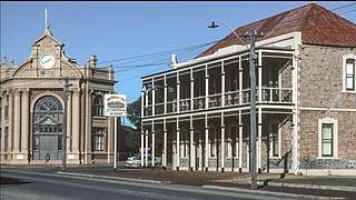
 York Post Office
 York Hospital
.jpg)
 York Flour Mill
 Westralia Bank
 Dinsdale's Shoe Emporium
Climate
York is in a temperate climate zone and experiences distinctly dry (and hot) summers[29] and cool, wet winters.[30] Under the Köppen climate classification, York has a Mediterranean climate.
Climate data has been recorded by the Bureau of Meteorology at York Post Office from 1877 to 1996,[31] and another site from 1996 onwards.[32]
At the post office site, the mean annual daily maximum temperature is 24.7 °C (76.5 °F) and the mean annual daily minimum temperature is 10.5 °C (50.9 °F).[31] The hottest month is January with a mean maximum temperature of 33.6 °C (92.5 °F), while the coolest month is July with a mean minimum temperature of 5.3 °C (41.5 °F).[31] Mean temperatures are based on data from 1880 to 1996.[31] York has a mean annual rainfall of 449.8 millimetres (17.71 in).[31] The wettest month is June with 87.9 millimetres (3.46 in) and the driest is January with 9.5 millimetres (0.37 in).[31]
A severe thunderstorm lashed the town and surrounding areas on 27 January 2011, resulting in roofs being ripped off, trees being uprooted and power lines being brought down.[33] About 40 houses were damaged in the town as a result of the storm but no injuries were reported.[34]
| Climate data for York and York Post Office (averages: 1880–1996; extremes: 1934–2016) | |||||||||||||
|---|---|---|---|---|---|---|---|---|---|---|---|---|---|
| Month | Jan | Feb | Mar | Apr | May | Jun | Jul | Aug | Sep | Oct | Nov | Dec | Year |
| Record high °C (°F) | 46.6 (115.9) |
47.4 (117.3) |
43.4 (110.1) |
39.0 (102.2) |
34.4 (93.9) |
25.6 (78.1) |
25.4 (77.7) |
27.9 (82.2) |
33.7 (92.7) |
40.0 (104) |
42.3 (108.1) |
45.5 (113.9) |
47.4 (117.3) |
| Average high °C (°F) | 33.6 (92.5) |
32.9 (91.2) |
30.0 (86) |
25.5 (77.9) |
20.6 (69.1) |
17.4 (63.3) |
16.4 (61.5) |
17.5 (63.5) |
20.1 (68.2) |
23.4 (74.1) |
27.9 (82.2) |
31.5 (88.7) |
24.7 (76.5) |
| Average low °C (°F) | 16.6 (61.9) |
16.7 (62.1) |
14.8 (58.6) |
11.3 (52.3) |
8.0 (46.4) |
6.4 (43.5) |
5.3 (41.5) |
5.4 (41.7) |
6.5 (43.7) |
8.4 (47.1) |
12.0 (53.6) |
14.9 (58.8) |
10.5 (50.9) |
| Record low °C (°F) | 7.4 (45.3) |
6.8 (44.2) |
3.2 (37.8) |
0.6 (33.1) |
−3.2 (26.2) |
−4.0 (24.8) |
−5.2 (22.6) |
−3.0 (26.6) |
−2.2 (28) |
0.0 (32) |
0.4 (32.7) |
2.7 (36.9) |
−5.2 (22.6) |
| Average rainfall mm (inches) | 9.5 (0.374) |
14.6 (0.575) |
16.8 (0.661) |
24.1 (0.949) |
60.5 (2.382) |
87.9 (3.461) |
85.5 (3.366) |
65.9 (2.594) |
37.4 (1.472) |
25.5 (1.004) |
12.6 (0.496) |
10.1 (0.398) |
450.4 (17.732) |
| Average rainy days (≥ 0.2mm) | 1.4 | 2.2 | 2.7 | 5.8 | 9.9 | 14.6 | 15.3 | 13.1 | 10.0 | 6.4 | 4.2 | 2.1 | 87.7 |
| Source: Bureau of Meteorology[31][32] | |||||||||||||
Facilities and attractions

The town has adapted by changing from a traditional sheep and wheat agricultural community into a tourist town. It features festivals, a motor museum, art galleries, recreational facilities including skydiving and paragliding, many bed and breakfast services and the picturesque Avon River. The town population in 2010 was approximately 3800 and increasing 4% annually.
York is well serviced with all essential facilities, including York District High School for students from kindergarten to Year 10. The York Visitor Centre is located in the Town Hall. The York Community Resource Centre enables access to tertiary education. There is a 24/7 medical service, the York District Hospital, library, and swimming pool.
See also
Notes
- ↑ e.g. Holy Trinity Church, Faversham House stage two, the Cell Block behind the Courthouse, the Castle Hotel old section, the Uniting Church chapel.
- ↑ Jewell was the architect for the Sisters of Mercy at the time.[26]
References
- ↑ Australian Bureau of Statistics (31 October 2012). "York (Urban Centre/Locality)". 2011 Census QuickStats. Retrieved 2 November 2012.

- 1 2 "Government Notice". The Perth Gazette and Western Australian Journal. 11 July 1835. p. 526. Retrieved 22 January 2016.
- ↑ "Perth Surrounds". State Heritage Office. Government of Western Australia. 10 June 2013. Retrieved 22 January 2016.
- ↑ A suggestion by J.S. Clarkson adopted by the Lieutenant Governor in 1830: John E Deacon: A Survey of the Historical Development of the Avon Valley with Particular Reference to York, Western Australia During the Years 1830-1850, UWA, 1948, pp.20 and 22.
- ↑ Dale, Robert (1833). "Journal of an Expedition under the direction of Ensign Dale, to the Eastward of the Darling Mountains; in August, 1831". Journals of Several Expeditions Made in Western Australia During the Years 1829, 1830, 1831 and 1832: Under the Sanction of the Governor, Sir James Stirling. London: Joseph Cross. pp. 51–61. Retrieved 23 January 2016.
- ↑ Dale, Robert (1833). "Journal of another Expedition to the Eastward of the Darling Range, under the direction of Ensign Dale; commenced on the 25th of October, and concluded on the 7th of November, 1830". Journals of Several Expeditions Made in Western Australia During the Years 1829, 1830, 1831 and 1832: Under the Sanction of the Governor, Sir James Stirling. London: Joseph Cross. pp. 62–72. Retrieved 23 January 2016.
- ↑ John E Deacon: A Survey of the Historical Development of the Avon Valley with Particular Reference to York, Western Australia During the Years 1830-1850, UWA, 1948, pp.16 and 25; N Ogle: The Colony of Western Australia, p.33.
- ↑ John E Deacon: A Survey of the Historical Development of the Avon Valley with Particular Reference to York, Western Australia During the Years 1830-1850, UWA, 1948, p.23; Survey Department Letter Books, SI, p.55
- 1 2 Hasluck, Paul ("Polygon") (12 September 1931). "Centenary of York – The First Inland Settlement". The West Australian. p. 4. Retrieved 23 January 2016.
- ↑ Dale, Robert (1833). "Letters from Mr. Dale, giving a summary description of the country passed over in going to Mount Bakewell, and, also, in an Expedition to examine the Country to the North and South of that place". Journals of Several Expeditions Made in Western Australia During the Years 1829, 1830, 1831 and 1832: Under the Sanction of the Governor, Sir James Stirling. London: Joseph Cross. pp. 155–160. Retrieved 23 January 2016.
- ↑ "The Western Australian Journal". The Perth Gazette and Western Australian Journal. 21 September 1833. p. 150. Retrieved 23 January 2016.
- ↑ "Government Notice". The Perth Gazette and Western Australian Journal. 12 October 1833. p. 161. Retrieved 23 January 2016.
- ↑ "Government Notice". The Perth Gazette and Western Australian Journal. 20 September 1834. p. 357. Retrieved 23 January 2016.
- ↑ A.M. Clack and Jenni McColl: York Sketchbook, p. 30.
- ↑ Landgate, Deeds and Ordinances I/166/625 Deed of Conveyance dated 30 April 1838.
- ↑ Perth Gazette and Western Australian Journal 8 April 1837, p.880.
- ↑ Stowe, W.E. (introduced by), The Avon Valley: embracing Newcastle, Northam, York, Beverley, 1905, p. 58.
- ↑ John E Deacon: A Survey of the Historical Development of the Avon Valley with Particular Reference to York, Western Australia During the Years 1830-1850, UWA, 1948, pp.53 and 74
- ↑ John E Deacon: A Survey of the Historical Development of the Avon Valley with Particular Reference to York, Western Australia During the Years 1830-1850, UWA, 1948, pp.53 and 74.
- ↑ John E Deacon: A Survey of the Historical Development of the Avon Valley with Particular Reference to York, Western Australia During the Years 1830-1850, UWA, 1948, p.75.
- ↑ John E Deacon: A Survey of the Historical Development of the Avon Valley with Particular Reference to York, Western Australia During the Years 1830-1850, UWA, 1948, p.132 et seq.
- ↑ John E Deacon: A Survey of the Historical Development of the Avon Valley with Particular Reference to York, Western Australia During the Years 1830-1850, UWA, 1948, pp.165, 173 and 218.
- ↑ Inquirer 28 January, 1852, p.3.; Perth Gazette and Independent Journal of Politics and News 10 June 1857; Inquirer and Commercial News, 3 February 1858, p.1.
- ↑ St. Patrick's Catholic Church, York, Western Australia," Medievalism in Australian Cultural Memory, accessed 19 August 2013.
- ↑ AM (Tony) Clack and Jenni McColl, York Sketchbook, The York Society, 2003, back cover.
- ↑ Perth Gazette 18 November 1870 page 3
- ↑ Van Bremen, I. H. (Ingrid H.); National Trust of Australia (W.A.); Heritage Council of Western Australia (1993), York Court House, police station & lock-up : conservation plan for the National Trust of Australia (W.A.), The Trust, retrieved 16 December 2016
- ↑ Ray and John Oldham: George Temple-Poole - Architect of the Golden Years 1885-1897, UWA Press, 1980
- ↑ "Australian Climatic Zones – All Climate Classes(Map)". Bureau of Meteorology website. Bureau of Meteorology. Archived from the original on 5 August 2009. Retrieved 8 May 2010.
- ↑ "Australian Climatic Zones (Map)". Bureau of Meteorology website. Bureau of Meteorology. Archived from the original on 2 September 2013. Retrieved 8 May 2010.
- 1 2 3 4 5 6 7 "Monthly Climate Statistics for Australian Locations – York Post Office". Bureau of Meteorology website. Bureau of Meteorology. Retrieved 3 December 2016.
- 1 2 "Monthly Climate Statistics for Australian Locations – York Post Office". Bureau of Meteorology website. Bureau of Meteorology. Retrieved 3 December 2016.
- ↑ "Wheatbelt towns lashed by thunderstorms, but cyclone warning cancelled". The Sunday Times. 28 January 2011. Retrieved 24 April 2011.
- ↑ "Houses damaged in trail of destruction across WA". The West Australian. 31 January 2011. Retrieved 24 April 2011.
External links
| Wikivoyage has a travel guide for York (Western Australia). |
![]()