City of Wanneroo
| City of Wanneroo Western Australia | |||||||||||||||
|---|---|---|---|---|---|---|---|---|---|---|---|---|---|---|---|
 | |||||||||||||||
| Population | 188,212 (2016 census)[1] (27th) | ||||||||||||||
| • Density | 274.442/km2 (710.80/sq mi) | ||||||||||||||
| Established | 1902 | ||||||||||||||
| Area | 685.8 km2 (264.8 sq mi) | ||||||||||||||
| Mayor | Tracey Roberts | ||||||||||||||
| Council seat | Wanneroo | ||||||||||||||
| Region | North metropolitan Perth | ||||||||||||||
| State electorate(s) | Wanneroo, Burns Beach, Butler, Girrawheen, Mirrabooka, West Swan | ||||||||||||||
| Federal Division(s) | Cowan, Moore, Pearce | ||||||||||||||
 | |||||||||||||||
| Website | City of Wanneroo | ||||||||||||||
| |||||||||||||||
The City of Wanneroo is a local government area with city status in the northern suburbs of Perth, Western Australia. It is centred approximately 25 kilometres (15.5 mi) north of Perth's central business district and forms part of the northern boundary of the Perth metropolitan area.
The city's main commercial and residential town centres are located at Wanneroo in the east and Clarkson in the north. Further urban centres are planned at Alkimos, Yanchep and Two Rocks in the future to coincide with rapid metropolitan expansion and development in the area.[2] It is also home to the Yanchep and Neerabup National Parks, as well as the Neerabup Industrial Estate in the north.
From the city's inception until 1998, it also incorporated the neighbouring City of Joondalup in its entirety.
Geography
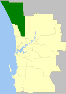
Wanneroo covers a land area totalling 685.8 square kilometres (264.8 sq mi). The city is bounded by Beach Road and the City of Stirling to the south, Alexander Drive and the City of Swan to the east, Wanneroo Road and Lake Joondalup to the south-west, the Indian Ocean to the west and the Shire of Gingin to the north.
Wanneroo's population is concentrated in three locations: at the southern end centred on Girrawheen; in the region surrounding Wanneroo near the city's geographical centre; and along the northern Perth coastline centred on Clarkson, separated from Joondalup by the rural localities of Neerabup and Tamala Park. Land in the city's north and east is predominantly rural in character.
Suburbs
The city's 36 suburbs and localities are grouped into the following four electoral wards:[3]
| Ward | Suburbs, villages and districts |
|---|---|
| North Coast Ward | Alkimos, Butler, Clarkson, Eglinton, Jindalee, Merriwa, Mindarie, Quinns Rocks, Ridgewood, Tamala Park, Two Rocks, Yanchep |
| Central Ward | Ashby, Banksia Grove, Carabooda, Carramar, Hocking, Jandabup, Mariginiup, Neerabup, Nowergup, Pinjar, Pearsall, Sinagra, Tapping, Wanneroo |
| South Ward | Alexander Heights, Darch, Girrawheen, Gnangara, Koondoola, Landsdale, Madeley, Marangaroo, Wangara, Woodvale* |
* Part of Woodvale is located within the City of Joondalup.
History
Prior to 1902, Wanneroo was part of the Perth Road District, which eventually went on to become the City of Stirling. Wanneroo was established on 31 October 1902 as a road board under the Roads Act 1888. The board was named after the Wanneroo wetlands in the area, first explored and recorded by John Butler in 1834.[4]
With the passage of the Local Government Act 1960, all road boards became shires effective from 1 July 1961,[5] and the Shire of Wanneroo came into being, encompassing everything north of Beach Road and west of Alexander Drive. With the development of and subsequent population growth surrounding Joondalup, the Shire of Wanneroo attained City status on 31 October 1985.[6]
On 1 July 1998, on the recommendation of a report by the Local Government Advisory Committee, the City of Wanneroo was bifurcated. The southwestern section, encompassing the urban centre of Joondalup, was separately incorporated as the new City of Joondalup. The remainder, including the inland suburbs east of Lake Joondalup and the coastal suburbs north of Burns Beach, formed a reduced Shire of Wanneroo, which quickly regained City status on 1 July 1999.[7] As this was before the local government elections to elect a mayor and councillors, the second incarnation of the Shire did not have a Shire President.[8]
Demographics
The City of Wanneroo has experienced significant population growth of almost 110,000 persons in the 15 years between the 2001 Census and 2016 Census. The city also has the second largest population of any other local government area in greater Perth.
| Selected historical census data for Wanneroo local government area | ||||||
|---|---|---|---|---|---|---|
| Census year | 2001[9] | 2006[10] | 2011[11] | 2016[1] | ||
| Population | Estimated residents on census night | 80,008 | 110,940 | 152,077 | 188,212 | |
| LGA rank in terms of size within Western Australia | 3rd | |||||
| % of Western Australia population | 4.37% | |||||
| % of Australian population | 0.43% | |||||
| Cultural and language diversity | ||||||
| Ancestry, top responses | English | 31.0% | ||||
| Australian | 21.5% | |||||
| Scottish | 6.2% | |||||
| Irish | 5.7% | |||||
| Italian | 3.6% | |||||
| Language, top responses (other than English) | Vietnamese | 3.8% | ||||
| Italian | 1.8% | |||||
| Macedonian | 1.4% | |||||
| Arabic | 0.6% | |||||
| Polish | 0.5% | |||||
| Spanish | 0.5% | |||||
| Afrikaans | 1.3% | |||||
| Gujarati | 0.9% | |||||
| Mandarin | 0.9% | |||||
| Religious affiliation | ||||||
| Religious affiliation, top responses | Catholic | 25.3% | ||||
| Anglican | 21.3% | |||||
| No religion | 19.3% | |||||
| Buddhism | 3.5% | |||||
| Uniting | 2.6% | |||||
| Median weekly incomes | ||||||
| Personal income | Median weekly personal income | A$491 | A$662 | A$724 | ||
| % of Australian median income | 105.4% | 114.7% | 109.4% | |||
| Family income | Median weekly family income | A$1184 | A$1722 | A$1910 | ||
| % of Australian median income | 101.1% | 116.2% | 110.2% | |||
| Household income | Median weekly household income | A$1094 | A$1415 | A$1595 | ||
| % of Australian median income | 106.5% | 114.7% | 110.9% | |||
With less than 53% of the population having been born in Australia at the 2016 Census, Wanneroo has a large immigrant populace. Over 13% of Wanneroo's residents were born in the United Kingdom, compared to less than 4.0% nationwide. New Zealanders, Vietnamese and South Africans compose the city's most significant minority populations.[12]
| Year | Population |
|---|---|
| 1911 | 197 |
| 1921 | 312 |
| 1933 | 694 |
| 1947 | 947 |
| 1954 | 1,299 |
| 1961 | 1,732 |
| 1966 | 2,437 |
| 1971 | 8,620 |
| 1976 | 55,328 |
| 1981 | 93,611 |
| 1986 | 126,053 |
| 1991 | 167,176* |
| 1996 | 201,853* |
| 2001 | 80,008 |
| 2006 | 110,940 |
| 2011 | 152,077 |
| 2016 | 188,212 |
- The 1991 population included 45,024 in what is now the City of Wanneroo, with the rest located in the City of Joondalup area. Similarly, the 1996 population includes 61,660 for Wanneroo.
Transport
The City of Wanneroo is served by two major north–south arterial roads, Wanneroo Road and Marmion Avenue. The two roads run parallel to each other through Wanneroo's eastern and western suburbs respectively. A third north–south arterial route, the Mitchell Freeway, is proposed to be extended from Burns Beach Road through to Toreopango Avenue and beyond.
The City of Wanneroo currently has two railway stations in Clarkson and Butler. As a result of the Public Transport Plan for Perth 2031, the Clarkson rail line is proposed to be extended north to Yanchep with stations at Alkimos, Eglinton, and Yanchep.
Governance
The Wanneroo City Council operates out of the Council Chambers on Dundebar Road, Wanneroo.
Elections are held every four years, for a mayor and 14 councillors across the city's four electoral wards. In 2011, five councillors were elected for the densely populated and urbanised South Ward, compared to four for the North Coast Ward, and four for the Central Ward.[13]
Sister cities
Wanneroo has three sister cities. It was also formerly twinned with Sorrento in Italy, but this association was broken with the bifurcation of Wanneroo in 1998, when the Wanneroo suburb of Sorrento was incorporated into the City of Joondalup.[14]
References
- 1 2 Australian Bureau of Statistics (27 June 2017). "Wanneroo (C)". 2016 Census QuickStats. Retrieved 26 November 2017.

- ↑ Draft Urban Expansion Plan, Department of Planning
- ↑ City of Wanneroo. "Suburb Maps". Archived from the original on 18 September 2011.
- ↑ "Wanneroo Roads District". Western Australia Government Gazette. 22 October 1902. p. 1902:4213.
- ↑ "Local Government Act, 1960. Names and Common Seals of Municipalities. Order in Council. (per L.G. 824/60, 860/60)". Western Australia Government Gazette. 23 June 1961. p. 1961:1995–2000.
- ↑ "Local Government Act 1960 – City of Wanneroo (City Status) Order 1985". Western Australia Government Gazette. 19 July 1985. p. 1985:2514.
- ↑ "City of Wanneroo (Reinstatement of Council) Order 1998". Western Australia Government Gazette. 26 June 1998. p. 1998:3430.
* "Joondalup and Wanneroo Order 1998". Western Australia Government Gazette. 26 June 1998. p. 1998:3431–3444. - ↑ WA Electoral Commission, Municipality Boundary Amendments Register (release 2.0), 31 May 2003.
- ↑ Australian Bureau of Statistics (9 March 2006). "Wanneroo (C)". 2001 Census QuickStats. Retrieved 3 December 2017.
- ↑ Australian Bureau of Statistics (25 October 2007). "Wanneroo (C)". 2006 Census QuickStats. Retrieved 3 December 2017.
- ↑ Australian Bureau of Statistics (31 October 2012). "Wanneroo (C)". 2011 Census QuickStats. Retrieved 3 December 2017.
- ↑ Australian Bureau of Statistics (27 June 2017). "Wanneroo (C) (Local Government Area)". 2016 Census QuickStats. Retrieved 4 December 2017.
- ↑ City of Wanneroo. "Elected Members – Wards".
- ↑ City of Wanneroo. "Sister City Arrangements – Council Minutes – 20 March 2001" (PDF).
External links
Suburbs and localities of the City of Wanneroo, Perth, Western Australia | ||
|---|---|---|
| North West | | |
| North East | ||
| South | ||
¹ Suburb shared with the City of Joondalup | ||