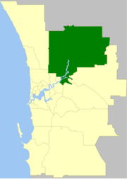
City of Swan
| City of Swan Western Australia | |||||||||||||||
|---|---|---|---|---|---|---|---|---|---|---|---|---|---|---|---|
 | |||||||||||||||
| Population | 133,851 (2016 census)[1] | ||||||||||||||
| • Density | 128.33/km2 (332.38/sq mi) | ||||||||||||||
| Established | 1871 | ||||||||||||||
| Area | 1,043 km2 (402.7 sq mi) | ||||||||||||||
| Mayor | David Lucas | ||||||||||||||
| Council seat | Midland | ||||||||||||||
| Region | Eastern Metropolitan Perth, Swan Valley | ||||||||||||||
| State electorate(s) | Bassendean, Midland, Swan Hills, West Swan, Mirrabooka | ||||||||||||||
| Federal Division(s) | Swan, Cowan, Hasluck, Pearce | ||||||||||||||
 | |||||||||||||||
| Website | City of Swan | ||||||||||||||
| |||||||||||||||
The City of Swan is a local government area of Western Australia. It is in Perth's eastern metropolitan region and includes the Swan Valley, centred approximately 20 km north-east of the Perth Central Business District (CBD). The City covers an area of 1,043 km² (much of which is uninhabited) and had a population of almost 134,000 as at the 2016 Census. At the 2001 census, 10% of the population were born in the United Kingdom, while significant Southern European and South-East Asian minorities are also located here.
History
The City of Swan began as three entities:
- The Municipality of Guildford, gazetted in 1871.
- The Municipality of Helena Vale, gazetted in 1895, becoming the Municipality of Midland Junction in 1901 and the Town of Midland in 1961.
- The Swan Roads Board, gazetted in 1871.
On 1 July 1961, Guildford and the Swan Roads Board merged into the Shire of Swan-Guildford. Swan-Guildford and Midland united on 1 April 1970 as the Shire of Swan, and 30 years later, on 1 April 2000, became the City of Swan.[2]
On 1 July 2016 the portion of Noranda north of Widgee Road was transferred to the City of Bayswater.[3]
Wards
The City of Swan is divided into 5 wards, most of which have three Councillors:[4]
- Altone Ward (3 Councillors)
- Midland/Guildford Ward (3 Councillors)
- Pearce Ward (4 Councillors)
- Swan Valley/Gidgegannup Ward (2 Councillors)
- Whiteman Ward (3 Councillors)
Councillors
- Altone Ward - Cr David Lucas (Mayor), Cr Andrew Kiely, Cr Peter Lyndon-James
- Midland Ward - Cr Mark Elliot, Cr Claire Scanlan, Cr Ian Johnson
- Pearce Ward - Cr Kevin Bailey (Deputy Mayor), Cr David McDonnell, Cr Patty Jones, Cr Cate McCullough
- Swan Valley/Gidgegannup Ward - Cr Charlie Zannino, Cr Rod Henderson
- Whiteman Ward - Cr Adam Kovalevs, Cr Maria Haynes, Cr John McNamara
Suburbs
- Aveley
- Ballajura
- Baskerville
- Beechboro
- Belhus
- Bellevue
- Bennett Springs
- Brabham
- Brigadoon
- Bullsbrook
- Bushmead
- Caversham
- Cullacabardee
- Dayton
- Ellenbrook
- Gidgegannup
- Guildford
- Hazelmere
- Henley Brook
- Herne Hill
- Jane Brook
- Kiara
- Koongamia
- Lexia
- Lockridge
- Malaga
- Melaleuca
- Middle Swan
- Midland
- Midvale
- Millendon
- Red Hill
- Stratton
- South Guildford
- Swan View
- The Vines
- Upper Swan
- Viveash
- West Swan
- Whiteman
- Woodbridge
Population
The populations of the City of Swan's antecedents were:
| Year | Total | Swan | Guildford | Midland |
|---|---|---|---|---|
| 1911 | 6,982 | 1,829 | 1,669 | 3,484 |
| 1921 | 9,188 | 2,375 | 1,876 | 4,937 |
| 1933 | 10,948 | 3,501 | 2,039 | 5,408 |
| 1947 | 13,446 | 5,047 | 2,217 | 6,182 |
| 1954 | 17,996 | 7,366 | 2,134 | 8,496 |
| 1961 | 18,653 | 9,397 | 9,256 | |
| 1966 | 19,135 | 9,800 | 9,335 | |
The post-1970 populations of the combined Shire/City of Swan were:
| Year | Population |
|---|---|
| 1971 | 25,682 |
| 1976 | 26,932 |
| 1981 | 31,859 |
| 1986 | 37,383 |
| 1991 | 52,968 |
| 1996 | 68,795 |
| 2001 | 82,126 |
| 2006 | 93,279 |
| 2011 | 108,461 |
| 2016 | 133,851 |
References
- ↑ Australian Bureau of Statistics (27 June 2017). "Swan (C)". 2016 Census QuickStats. Retrieved 26 November 2017.

- ↑ WA Electoral Commission, Municipality Boundary Amendments Register (release 2.0), 31 May 2003.
- ↑ Pascual Juanola, Marta (31 March 2016). "Noranda joins Baysy". The Perth Voice. Retrieved 9 April 2016.
- ↑ Ward Map, City of Swan, 21 October 2017 (accessed 17 April 2018)