
Seven of the active volcanoes of Java
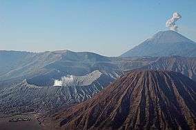
Mt. Semeru and Mt. Bromo in East Java
The Indonesian island of Java is almost entirely of volcanic origin, and contains numerous volcanoes, 45 of which are considered active volcanoes. As is the case for many other Indonesian islands, volcanoes have played a vital role in the geological and human history of Java. Indeed, land is created on Java as a result of lava flows, ash deposits, and mud flows (lahars). Volcanoes are a major contributor to the immense fertility of Java, as natural erosion transports volcanic material as alluvium to the island's plains, forming thick layers of fertile sediment. The benefit is not just in the immediate vicinity of the volcano, with fine ash emitted from eruptions being dispersed over wide areas.
Climbing volcanoes (and other mountains) is increasingly popular.
List of volcanoes
This list is of volcanoes from the west of Java to the east. Local terminology and usage has the word Gunung (mount or mountain) precede the names
East Java
- Kelut Stratovolcano
- Kawi-Butak Stratovolcanoes
- Arjuno-Welirang Stratovolcano
- Penanggungan Stratovolcano
- Malang Plain Maars
- Semeru Stratovolcano
- Mount Bromo
- Lamongan Stratovolcano
- Lurus Complex volcano Mount Lurus
- Iyang-Argapura Complex volcano
- Raung Stratovolcano
- Ijen Stratovolcanoes
- Baluran Stratovolcano
List of active volcanoes
| Name |
Shape |
Elevation |
Last eruption (VEI) |
Geolocation |
| m |
ft |
| Krakatau | caldera |
813 |
2,667 |
11 Jan 2011 ( ) |
6°06′07″S 105°25′23″E / 6.102°S 105.423°E / -6.102; 105.423 |
| Pulosari | stratovolcano |
1,346 |
4,416 |
unknown |
6°20′31″S 105°58′30″E / 6.342°S 105.975°E / -6.342; 105.975 |
| Gunung Karang | stratovolcano |
1,778 |
5,833 |
unknown |
6°16′12″S 106°02′31″E / 6.27°S 106.042°E / -6.27; 106.042 |
| Kiaraberes-Gagak | stratovolcano |
1,511 |
4,957 |
6 Apr 1939 (1) |
6°44′S 106°39′E / 6.73°S 106.65°E / -6.73; 106.65 |
| Perbakti | stratovolcano |
1,699 |
5,574 |
unknown |
6°45′S 106°41′E / 6.75°S 106.68°E / -6.75; 106.68 |
| Salak | stratovolcano |
2,211 |
7,254 |
31 Jan 1938 (2) |
6°43′S 106°44′E / 6.72°S 106.73°E / -6.72; 106.73 |
| Gede | stratovolcano |
2,958 |
9,705 |
13 Mar 1957 (2) |
6°47′S 106°59′E / 6.78°S 106.98°E / -6.78; 106.98 |
| Patuha | stratovolcano |
2,434 |
7,986 |
unknown |
7°09′36″S 107°24′00″E / 7.160°S 107.40°E / -7.160; 107.40 |
| Wayang-Windu | lava dome |
2,182 |
7,159 |
unknown |
7°12′29″S 107°37′48″E / 7.208°S 107.63°E / -7.208; 107.63 |
| Malabar | stratovolcano |
2,343 |
7,687 |
unknown |
7°08′S 107°39′E / 7.13°S 107.65°E / -7.13; 107.65 |
| Tangkuban Perahu | stratovolcano |
2,084 |
6,837 |
14 Sep 1983 (1) |
6°46′S 107°36′E / 6.77°S 107.60°E / -6.77; 107.60 |
| Papandayan | stratovolcano |
2,665 |
8,743 |
11 Nov 2002 (2) |
7°19′S 107°44′E / 7.32°S 107.73°E / -7.32; 107.73 |
| Kendang | stratovolcano |
2,608 |
8,556 |
unknown |
7°14′S 107°43′E / 7.23°S 107.72°E / -7.23; 107.72 |
| Kamojang | stratovolcano |
1,730 |
5,680 |
Pleistocene |
7°07′30″S 107°48′00″E / 7.125°S 107.80°E / -7.125; 107.80 |
| Guntur | complex volcano |
2,249 |
7,379 |
16 Oct 1847 (2) |
7°08′35″S 107°50′24″E / 7.143°S 107.840°E / -7.143; 107.840 |
| Tampomas | stratovolcano |
1,684 |
5,525 |
unknown |
6°46′S 107°57′E / 6.77°S 107.95°E / -6.77; 107.95 |
| Galunggung | stratovolcano |
2,168 |
7,113 |
9 Jan 1984 (1) |
7°15′00″S 108°03′29″E / 7.25°S 108.058°E / -7.25; 108.058 |
| Talagabodas | stratovolcano |
2,201 |
7,221 |
unknown |
7°12′29″S 108°04′12″E / 7.208°S 108.07°E / -7.208; 108.07 |
| Karaha | fumarole |
1,155 |
3,789 |
unknown |
7°07′S 108°05′E / 7.12°S 108.08°E / -7.12; 108.08 |
| Cereme | stratovolcano |
3,078 |
10,098 |
1951 |
6°53′31″S 108°24′00″E / 6.892°S 108.40°E / -6.892; 108.40 |
| Slamet | stratovolcano |
3,432 |
11,260 |
1 May 1999 (1) |
7°14′31″S 109°12′29″E / 7.242°S 109.208°E / -7.242; 109.208 |
| Dieng | complex volcano |
2,565 |
8,415 |
31 Dec 1996 (1) |
7°12′S 109°55′E / 7.20°S 109.92°E / -7.20; 109.92 |
| Sundoro | stratovolcano |
3,136 |
10,289 |
29 Oct 1971 (2) |
7°18′00″S 109°59′31″E / 7.30°S 109.992°E / -7.30; 109.992 |
| Sumbing | stratovolcano |
3,371 |
11,060 |
1730 (1) |
7°23′02″S 110°04′12″E / 7.384°S 110.070°E / -7.384; 110.070 |
| Ungaran | stratovolcano |
2,050 |
6,730 |
unknown |
7°11′S 110°20′E / 7.18°S 110.33°E / -7.18; 110.33 |
| Telomoyo | stratovolcano |
1,894 |
6,214 |
unknown |
7°22′S 110°24′E / 7.37°S 110.40°E / -7.37; 110.40 |
| Merbabu | stratovolcano |
3,145 |
10,318 |
1797 (2) |
7°27′S 110°26′E / 7.45°S 110.43°E / -7.45; 110.43 |
| Merapi | stratovolcano |
2,968 |
9,738 |
26 Oct 2010[1] |
7°32′31″S 110°26′31″E / 7.542°S 110.442°E / -7.542; 110.442 |
| Muria | stratovolcano |
1,625 |
5,331 |
160 ± 30 years |
6°37′S 110°53′E / 6.62°S 110.88°E / -6.62; 110.88 |
| Lawu | stratovolcano |
3,265 |
10,712 |
28 Nov 1885 (1) |
7°37′30″S 111°11′31″E / 7.625°S 111.192°E / -7.625; 111.192 |
| Wilis | stratovolcano |
2,563 |
8,409 |
unknown |
7°48′29″S 111°45′29″E / 7.808°S 111.758°E / -7.808; 111.758 |
| Kelud | stratovolcano |
1,731 |
5,679 |
13 Feb 2014 |
7°55′48″S 112°18′29″E / 7.93°S 112.308°E / -7.93; 112.308 |
| Kawi-Butak | stratovolcano |
2,651 |
8,698 |
unknown |
7°55′S 112°27′E / 7.92°S 112.45°E / -7.92; 112.45 |
| Arjuno-Welirang | stratovolcano |
3,339 |
10,955 |
15 Aug 1952 (0) |
7°43′30″S 112°34′48″E / 7.725°S 112.58°E / -7.725; 112.58 |
| Penanggungan | stratovolcano |
1,653 |
5,423 |
unknown |
7°37′S 112°38′E / 7.62°S 112.63°E / -7.62; 112.63 |
| Malang Plain | maar |
680 |
2,230 |
unknown |
8°01′S 112°41′E / 8.02°S 112.68°E / -8.02; 112.68 |
| Semeru | stratovolcano |
3,676 |
12,060 |
1967–2006 continuing (3) |
8°06′29″S 112°55′12″E / 8.108°S 112.92°E / -8.108; 112.92 |
| Tengger | stratovolcano |
2,329 |
7,641 |
8 Jun 2004 (2) |
7°56′31″S 112°57′00″E / 7.942°S 112.95°E / -7.942; 112.95 |
| Lamongan | stratovolcano |
1,651 |
5,417 |
5 Feb 1898 (2) |
7°58′44″S 113°20′31″E / 7.979°S 113.342°E / -7.979; 113.342 |
| Lurus | complex volcano |
539 |
1,768 |
unknown |
7°44′S 113°35′E / 7.73°S 113.58°E / -7.73; 113.58 |
| Iyang-Argapura | complex volcano |
3,088 |
10,131 |
unknown |
7°58′S 113°34′E / 7.97°S 113.57°E / -7.97; 113.57 |
| Raung | stratovolcano |
3,332 |
10,932 |
2 Jun 2002 (2) |
8°07′30″S 114°02′31″E / 8.125°S 114.042°E / -8.125; 114.042 |
| Ijen | stratovolcano |
2,799 |
9,183 |
28 Jun 1999 (1) |
8°03′29″S 114°14′31″E / 8.058°S 114.242°E / -8.058; 114.242 |
| Baluran | stratovolcano |
1,247 |
4,091 |
unknown |
7°51′S 114°22′E / 7.85°S 114.37°E / -7.85; 114.37 |
References
- Whitten, T, Soaeriaatmadja, R. E., Afiff, S. A., (editors), The Ecology of Java and Bali, Periplus Editions (HK) Ltd. 1996, Hardcover, 969 pages,
ISBN 962-593-072-8