Mount Ibu
| Mount Ibu | |
|---|---|
 | |
| Highest point | |
| Elevation | 1,325 m (4,347 ft) [1] |
| Listing | Ribu |
| Coordinates | 1°29′17″N 127°37′48″E / 1.488°N 127.63°E |
| Geography | |
| Location | Halmahera, Indonesia |
| Geology | |
| Mountain type | Stratovolcano |
| Last eruption | June 2017 |
| Climbing | |
| Easiest route | 84 |
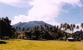
Mount Ibu (Indonesian: Gunung Ibu) is a stratovolcano located at the north-west coast of Halmahera island, Indonesia. The summit is truncated and contains nested craters. The inner crater is 1 km wide and 400 m deep, while the outer is 1.2 km wide. A large parasitic cone is located at the north-east of the summit and a smaller one at the south-west. The latter feeds a lava flow down the west flank. A group of maars are located on the western and northern side of the volcano.[1]
Latest activity
August 2009 Volcanological Survey of Indonesia raised the eruption alert level for Ibu to "Orange".[2]
See also
References
- 1 2 "Ibu". Global Volcanism Program. Smithsonian Institution. Retrieved 2006-12-31.
- ↑ Ibu alert "Orange"
This article is issued from
Wikipedia.
The text is licensed under Creative Commons - Attribution - Sharealike.
Additional terms may apply for the media files.