Mount Wurlali
| Mount Wurlali | |
|---|---|
 | |
| Highest point | |
| Elevation | 868 m (2,848 ft) [1] |
| Coordinates | 7°7′30″S 128°40′30″E / 7.12500°S 128.67500°E |
| Geography | |
 Mount Wurlali | |
| Geology | |
| Mountain type | Stratovolcano |
| Last eruption | June 1892 |
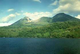
Mount Wurlali (also known as Mount Damar) is an andesitic stratovolcano on Damar Island in the Banda Arc system. Fumarolic activities with sulfur deposits are found at the twin summit craters and on the southeast flanks.[1]
The Wurlali is the most active volcano in historical time of the Banda arc. He was at the northern end of a five- kilometer-wide caldera. On the southwest flank of the crater occurs from sulfur. The last eruption took place in 1892.
In 1993 there was an earthquake, landslides, and smoke. Four-thousand people were evacuated. On January 23, 2003, there was an earthquake with a magnitude of 6.1. Close to the beach, south-west of the volcano, hot springs emerged.
See also
References
- 1 2 "Wurlali". Global Volcanism Program. Smithsonian Institution. Retrieved 2006-12-29.
This article is issued from
Wikipedia.
The text is licensed under Creative Commons - Attribution - Sharealike.
Additional terms may apply for the media files.