Inierie
| Inierie | |
|---|---|
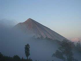 View of Mt. Inierie from the radio mast in Bajawa | |
| Highest point | |
| Elevation | 2,245 m (7,365 ft) |
| Listing |
Ultra Ribu |
| Coordinates | 8°52′30″S 120°57′00″E / 8.875°S 120.95°E |
| Geography | |
| Location | Flores Island, Indonesia |
| Geology | |
| Mountain type | Stratovolcano |
| Last eruption | 8050 BCE ? |
Inierie is a stratovolcano located in the south-central part of the island of Flores, Indonesia, overlooking the Savu Sea. It is the highest volcano on the island.
The volcano looms over the little town of Bajawa and is very impressive. The upper slopes are bare without any vegetation.
The volcano is not active but there is reports of smoke emerging from the crater in June 1911.
See also
References
This article is issued from
Wikipedia.
The text is licensed under Creative Commons - Attribution - Sharealike.
Additional terms may apply for the media files.