New Hanover Island
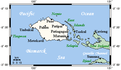 New Hanover closeup map | |
 New Hanover | |
| Geography | |
|---|---|
| Coordinates | 2°30′S 150°15′E / 2.5°S 150.25°E |
| Archipelago | Bismarck Archipelago |
| Area | 1,186 km2 (458 sq mi) |
| Length | 60 km (37 mi) |
| Width | 30 km (19 mi) |
| Highest elevation | 900 m (3,000 ft) |
| Administration | |
|
Papua New Guinea | |
| Province | New Ireland Province |
| District | Kavieng District |
| LLG | Lavongai Rural LLG |
| Demographics | |
| Population | 17,160 (2000) |
| Pop. density | 15.4 /km2 (39.9 /sq mi) |
New Hanover Island, (German: Neuhannover), also called Lavongai, is a large volcanic island in the New Ireland Province. This region is part of the Bismarck Archipelago of Papua New Guinea and lies at 2°30′S 150°15′E / 2.5°S 150.25°ECoordinates: 2°30′S 150°15′E / 2.5°S 150.25°E. Measuring some 460 square miles (1,200 km2), it had a population of 5,000 in 1960, which increased to approximately 17,160 by 2000.[1]
Culture
Friedrich Ratzel in The History of Mankind[2] reported in 1896, when discussing Melanesain ornament, that there were luxurious feather ornament displays in New Hanover, showing much taste in the combination of forms and colours with vegetable fibres and beads on sticks. An example was a delicately formed face in feather-mosaic forming the head of a hairpin.
See also
- Johnson cult (so called)
- List of volcanoes in Papua New Guinea
References
- ↑ PNG National Statistical Office: Census Unit Register, 2000
- ↑ Ratzel, Friedrich. The History of Mankind. (London: MacMillan, 1896). URL: www.inquirewithin.biz/history/american_pacific/oceania/melanesian-ornament.htm Archived 2011-07-06 at the Wayback Machine. accessed 21 October 2009.
External links
| Wikimedia Commons has media related to New Hanover. |
