Arrondissement of Rambouillet
| Rambouillet | |
|---|---|
| Arrondissement | |
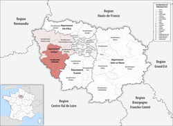 Location of Rambouillet in Île-de-France | |
| Country | France |
| Region | Île-de-France |
| Department | Yvelines |
| Communes | 83 |
| Subprefecture | Rambouillet |
| Area¹ | |
| • Total | 988.7 km2 (381.7 sq mi) |
| Population (2013) | |
| • Total | 223,370 |
| • Density | 230/km2 (590/sq mi) |
| ¹ French Land Register data, which exclude lakes, ponds, and glaciers larger than 1 km² as well as the estuaries of rivers. | |
The arrondissement of Rambouillet is an arrondissement of France in the Yvelines department in the Île-de-France region. Since the January 2017 reorganization of the arrondissements of Yvelines, it has 83 communes.[1]
Composition
Cantons
The cantons of the arrondissement of Rambouillet are:
- Aubergenville (partly)
- Maurepas (partly)
- Plaisir (partly)
- Rambouillet
- Trappes (partly)
Communes
The communes of the arrondissement of Rambouillet, and their INSEE codes, are:
- Ablis (78003)
- Allainville (78009)
- Auffargis (78030)
- Auteuil (78034)
- Autouillet (78036)
- Bazoches-sur-Guyonne (78050)
- Béhoust (78053)
- Beynes (78062)
- Boinville-le-Gaillard (78071)
- La Boissière-École (78077)
- Boissy-sans-Avoir (78084)
- Bonnelles (78087)
- Les Bréviaires (78108)
- Bullion (78120)
- La Celle-les-Bordes (78125)
- Cernay-la-Ville (78128)
- Chevreuse (78160)
- Choisel (78162)
- Clairefontaine-en-Yvelines (78164)
- Coignières (78168)
- Dampierre-en-Yvelines (78193)
- Élancourt (78208)
- Émancé (78209)
- Les Essarts-le-Roi (78220)
- Flexanville (78236)
- Galluis (78262)
- Gambais (78263)
- Gambaiseuil (78264)
- Garancières (78265)
- Gazeran (78269)
- Goupillières (78278)
- Grosrouvre (78289)
- Hermeray (78307)
- Jouars-Pontchartrain (78321)
- Lévis-Saint-Nom (78334)
- Longvilliers (78349)
- Magny-les-Hameaux (78356)
- Marcq (78364)
- Mareil-le-Guyon (78366)
- Maurepas (78383)
- Méré (78389)
- Le Mesnil-Saint-Denis (78397)
- Les Mesnuls (78398)
- Millemont (78404)
- Milon-la-Chapelle (78406)
- Mittainville (78407)
- Montfort-l'Amaury (78420)
- Neauphle-le-Château (78442)
- Neauphle-le-Vieux (78443)
- Orcemont (78464)
- Orphin (78470)
- Orsonville (78472)
- Paray-Douaville (78478)
- Le Perray-en-Yvelines (78486)
- Poigny-la-Forêt (78497)
- Ponthévrard (78499)
- Prunay-en-Yvelines (78506)
- La Queue-les-Yvelines (78513)
- Raizeux (78516)
- Rambouillet (78517)
- Rochefort-en-Yvelines (78522)
- Saint-Arnoult-en-Yvelines (78537)
- Sainte-Mesme (78569)
- Saint-Forget (78548)
- Saint-Germain-de-la-Grange (78550)
- Saint-Hilarion (78557)
- Saint-Lambert (78561)
- Saint-Léger-en-Yvelines (78562)
- Saint-Martin-de-Bréthencourt (78564)
- Saint-Rémy-lès-Chevreuse (78575)
- Saint-Rémy-l'Honoré (78576)
- Saulx-Marchais (78588)
- Senlisse (78590)
- Sonchamp (78601)
- Thiverval-Grignon (78615)
- Thoiry (78616)
- Le Tremblay-sur-Mauldre (78623)
- La Verrière (78644)
- Vicq (78653)
- Vieille-Église-en-Yvelines (78655)
- Villiers-le-Mahieu (78681)
- Villiers-Saint-Frédéric (78683)
- Voisins-le-Bretonneux (78688)
References
- ↑ "Arrêté préfectoral, 30 December 2016, p 33" (PDF). Retrieved 2017-08-01.
External links
This article is issued from
Wikipedia.
The text is licensed under Creative Commons - Attribution - Sharealike.
Additional terms may apply for the media files.