Narsinghpur State
| Narsinghpur State ନରସିଂହପୁର | |||||
| Princely State of British India | |||||
| |||||
 | |||||
| History | |||||
| • | Established | 1292 | |||
| • | Accession to the Union of India | 1948 | |||
| Area | |||||
| • | 1901 | 515 km2 (199 sq mi) | |||
| Population | |||||
| • | 1901 | 39,613 | |||
| Density | 76.9 /km2 (199.2 /sq mi) | ||||
Narsinghpur State (Odia: ନରସିଂହପୁର) was one of the princely states of India during the period of the British Raj. The state was founded in 1305 and had its capital in Narasinghpur town. The last ruler of Narsinghpur joined the state to the Indian Union in 1948 and Narsinghpur state was made part of the Cuttack district of Orissa.[1]
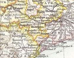
The state was bound in the north by a forested mountain range which marked the border with Hindol State and Angul District; in the east it was bound by Baramba State and in the south and southwest by the Mahanadi River.[2]
History
According to legend Narsinghpur was founded in 1292 by a Rajput named Dharma Singh after defeating two powerful Khond chiefs named Narsingh and Poro,[2] the state being named after the former.
The last ruler of Narsinghpur Princely State signed the accession to the Indian Union on 1 January 1948.
Rulers
Rulers of Narsinghpur bore the title 'Raja'.[3]
- 1671 – 1701 Mandardhar Harichandan Mohapatra
- 1701 – 1723 Kochali Harichandan Mohapatra
- 1723 – 1765 Biswambar Harichandan Mohapatra
- 1765 – 1775 Rrishna Chandra Harichandan Mohapatra
- 1775 – 1798 Nimai Charan Harichandan Mohapatra
- 1798 – 1826 Jaganath Harichandan Mohapatra
- 1826 – 1859 Somanath Harichandan Mohapatra
- 1859 – 1884 Braja Sundar Harichandan Mohapatra
- 4 Dec 1884 – 1912 Sadhu Charan Man Singh Harichandan (b. 1883 – d. 19..) Mohapatra
- 18 Jul 1912 – 5 Jul 1921 Ramchandra Man Singh Harichandan (b. 1906 – d. 1921) Mohapatra
- 5 Jul 1921 – 15 Aug 1947 Ananta Narayan Man Singh (b. 1908 – d. 1963) Harichandan Mohapatra
See also
References
- ↑ Narsinghpur Princely State
- 1 2 Imperial Gazetteer of India. 18. 1908. p. 385.
- ↑ Princely States of India K-W