Nayagarh State
| Nayagarh State | |||||
| Princely State of British India | |||||
| |||||
 | |||||
| History | |||||
| • | Established | c. 1500 | |||
| • | Accession to the Union of India | 1948 | |||
| Area | |||||
| • | 1931 | 1,528 km2 (590 sq mi) | |||
| Population | |||||
| • | 1931 | 142,406 | |||
| Density | 93.2 /km2 (241.4 /sq mi) | ||||
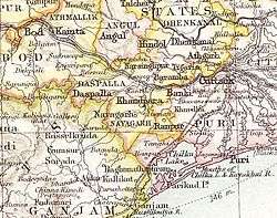
Nayagarh State was one of the princely states of India from the period of the British Raj.[1] It was located in present-day Nayagarh district, Odisha.
The state was bounded in the north by Khandpara State and Puri District. The capital was at Nayagarh. The southern part of the state was forested and mountainous and was inhabited mainly by Khonds.[2]
History
Nayagarh was founded before 1550 by Raja Surya Mani, a scion of the Rewa Royal Family. Khandpara State was initially part of Nayagarh State, but became a separate kingdom in 1599. The rulers were Rajputs of the Baghela or Vaghela dynasty.
Rulers
The rulers of Nayagarh State bore the title of Raja. The emblem of the Nayagarh royal family was the head of a tiger, the same state symbol as that of the rulers in neighbouring Khandpara State.[3]
Rajas
- .... - .... Chandrasekhar Singh Mandhata
- .... - .... Purushottam Singh Mandhata
- .... - 1784 Mrutyunjay Singh Mandhata
- 1784 - 1825 Binayak Singh Mandhata
- 1825 - 1851 Braja Babdhu Singh Mandhata
- 20 Sep 1851 - 1889 Ladhu Kishor Singh Mandhata (b. c.1843 - d. ....)
- 1889 - 1890 Balbhadra Singh
- 2 Mar 1890 - 4 Sep 1897 Raghunath Singh Mandhata
- 1897 - 7 Dec 1918 Narayan Singh Mandhata
- 7 Dec 1918 - 15 Aug 1947 Krishnachandra Singh Mandhata (b. 1911 - d. 1983)
- 4 Sept 1933 - 13 Aug 2012 Brajendra Kishore Singh Mandhata
- At present the King of Nayagarh is Rameswar Prasad Singh Mandhata(Continuing)
See also
References
- ↑

- ↑ Great Britain India Office. The Imperial Gazetteer of India. Oxford: Clarendon Press, 1908.
- ↑ Princely States of India