Saraikela State
| Saraikella State Seraikella State | |||||
| Princely State of British India | |||||
| |||||
 | |||||
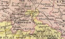 Imperial Gazetteer of India map | |||||
| History | |||||
| • | Established | 1620 | |||
| • | Independence of India | 1948 | |||
| Area | |||||
| • | 1892 | 1,163 km2 (449 sq mi) | |||
| Population | |||||
| • | 1892 | 77,097 | |||
| Density | 66.3 /km2 (171.7 /sq mi) | ||||
Saraikela State also spelt Seraikela, Saraikella or Seraikella, was an Odia princely state in India during the era of the British Raj.[2] Its capital was at Saraikela.
The state had an area of 1163 km², and was one of the nine Chota Nagpur States under the authority of the governor of Bengal Presidency.[3] The last ruler of the state, HH Raja Aditya Pratap Singh Deo, signed the merger agreement acceding to the Indian Union on 18 May 1948.
History
The state was founded in 1620 by Raja Bikram Singh (a forerunner to the ruling family's current nomenclature of Singh Deo), a descendant of the rulers of Porahat, who claimed descent from the Rathore clan of Videhas.[4] The state came under the influence of the Maratha rulers of Nagpur in the 18th century, and became a princely state of British India in 1803, at the conclusion of the Second Anglo-Maratha War at Deogaon of Orissa. After the war, the East India Company included the Saraikela princely state under the governance of the Chhota Nagpur Commissioner.
In 1912 Saraikela came under the authority of the province of Bihar and Orissa, which was newly created from the eastern districts of Bengal. In 1936 the state was placed under the authority of the Orissa Province. Saraikela, along with 24 other princely states of the Eastern States Agency, acceded to the Government of India on 1 January 1948, with a will to merge the princely state with Orissa province of the Indian Republic.
As a result both Saraikela and Kharsawan princely states were merged with Orissa in 1948. On 1 January 1948 itself, the tribals of these two princely states, who were in a majority, revolted against the merger with Orissa. This was supported by Patayet Sahib Maharajkumar Bhoopendra Narayan Singh Deo, third son of HH Raja Aditya Pratap Singh Deo, as a result of which he was imprisoned to ensure the popular movement died down. The central government appointed a commission under Mr. Baudkar to look into the matter. On the basis of the Baudkar commission report, Saraikela and Kharsawan princely states were merged with Bihar on 18 May 1948. These two princely states became part of Jharkhand when the state was separated from Bihar on 15 November 2000. From 18 May 1948 onward, many non-tribal Oriyas of the districts of Saraikela Kharsawan, East Singhbhum, and West Singhbhum have migrated and settled permanently in Orissa.
Rulers
The current scions of the former ruling family are residing at The Palace, while pursuing business interests (real-estate, agriculture and politics) locally and in Bhubaneshwar and Kolkata, include Rajkumar Pratap Aditya Singh Deo (son of HH Raja Shata Bhanu Singh Deo), Rajkumar Jugobhanu Singh Deo (son of Tikayat Sahib Maharajkumar Nrupendra Narayan Singh Deo), Maharajkumar Jairaj Singh Deo (son of Patayet Sahib Maharajkumar Bhoopendra Narayan Singh Deo) and Rajkumar Rajvikram Singh Deo.
Former rulers bore the title of 'Kunwar' until 1884.[5]
Kunwars
- 1620 – .... Bikram Singh I
- .... – .... Nru Singh
- 1728 – 1743 Satrughan Singh
- c.1743 – 1818 Abhiram Singh (d. 1818)
- 1818 – 1823 Bikram Singh II (d. 1823)
- 1823 – 1837 Ajamber Singh (d. 1837)
- 1837 – 1883 Chakradhar Singh (b. 1808 – d. 1883)
- 25 Nov 1883 – Nov 1884 Udit Narayan Singh (b. 1849 – d. 1931)
Rajas
- Nov 1884 – 1922 Udit Narayan Singh (s.a.)
Maharajas
- 1922 – 9 Dec 1931 Udit Narayan Singh (s.a.)
- 9 Dec 1931 – 15 Aug 1947 Aditya Pratap Singh (b. 1887 – d. 1969)
See also
References
- 1 2 "The Unfinished Task of Orissa Formation" (PDF). Retrieved 2018-06-09.
- ↑ Imperial Gazetteer2 of India, Volume 22, page 83 - Imperial Gazetteer of India - Digital South Asia Library. Dsal.uchicago.edu. Retrieved 2012-07-11.
- ↑

- ↑ Rajput Provinces of India - Seraikella (Princely State)
- ↑ Princely States of India
Coordinates: 22°41′52″N 85°58′28″E / 22.69778°N 85.97444°E