Gangpur State
| Gangpur State Gangpore State ଗଙ୍ଗାପୁର | |||||
| Princely State of British India | |||||
| |||||
 | |||||
| History | |||||
| • | Established | 1821 | |||
| • | Accession to the Indian Union | 1948 | |||
| Area | |||||
| • | 1941 | 6,454 km2 (2,492 sq mi) | |||
| Population | |||||
| • | 1941 | 398,171 | |||
| Density | 61.7 /km2 (159.8 /sq mi) | ||||
Gangpur State, also known as Gangpore State,[1] was one of the princely states of India during the period of the British Raj. Until 1905 it was one of the Chhota Nagpur States[2] under the Eastern States Agency.
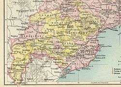
Covering an area of 6454 km², in 1941 Gangpur had a population of 398,171. The population was predominantly Oriya speaking.[3] It was made part of India on 1 January 1948. The capital of Gangpur State was modern Sundargarh of Odisha.
History
Gangpur was a feudatory estate of Sambalpur. In 1821 the British authorities canceled the feudatory rights of Sambalpur over Gangpur and the ruler was granted a sanad, by which Gangpur was recognized as a state.[4]
Rulers
The rulers of Gangpur bore the title of Raja from 1874 onward.[5]
- .... – 1804 Baijnath Shekhar Deo
- 1804 – 1820 Indra Shekhar Deo
- 1820 – 26 Feb 1831 Parsharam Shekhar Deo (d. 1831)
- 1831 – 1852 Jagadev Shekhar Deo
- 1852 – 1858 Chandrabhanu Shekhar Deo
- 1858 Madan Mohand Shekhar Deo
- 28 Oct 1858 – 1874 Raghunath Shekhar Deo (b. 1849 – d. 1917)
Rajas
- 1874 – 1917 Raghunath Shekhar Deo (s.a.) (personal style Maharaja from 1915)
- 10 Jun 1917 – 5 May 1930 Bhawani Shankar Shekhar Deo (b. 1898 – d. 1930)
- 5 May 1930 – 26 Dec 1938 Bir Mitra Pratap Shekhar Deo (b. 1920 – d. 1938)
- 5 May 1930 – 26 Dec 1938 Rani Janaki Rathnayammarjee of Kurupam (f) —Regent
- 26 Dec 1938 – 15 Aug 1947 Bir Pratap Shekhar Deo (b. 1923 – d. 1967)
- 26 Dec 1938 – 27 Nov 1944 Rani Janaki Rathnayammarjee of Kurupam (f) —Regent*
References
- ↑ "Imperial Gazetter of India, Volume 21, page 199 -- Imperial Gazetteer of India -- Digital South Asia Library". dsal.uchicago.edu.
- ↑

- ↑ Columbia-Lippincott Gazetteer p. 660
- ↑ The Imperial Gazetteer of India. London, Trübner & co., 1885.
- ↑ "Indian states before 1947 A-J". rulers.org.
External links
Coordinates: 22°07′N 84°02′E / 22.12°N 84.03°E