Nilgiri State
| Nilgiri State ନିଳଗିରି ରାଜ୍ୟ | |||||
| Princely State of British India | |||||
| |||||
 | |||||
| History | |||||
| • | Established | 1125 | |||
| • | Accession to the Union of India | 1949 | |||
| Area | |||||
| • | 1931 | 723 km2 (279 sq mi) | |||
| Population | |||||
| • | 1931 | 68,594 | |||
| Density | 94.9 /km2 (245.7 /sq mi) | ||||

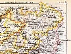
Nilgiri State (Odia: ନିଳଗିରି ରାଜ୍ୟ) was one of the Princely States of India during the British Raj. It belonged to the Orissa States Agency and its capital was at Raj Nilgiri,[1] which is the modern town of Nilagiri.
The state was bounded in the north and west by the State of Mayurbhanj and in the south by Balasore District. As of 1940 Nilgiri State had a population of 73,109 and an area of 263 square miles (680 km2). In 1949 it was merged into Balasore District.[2]
History
According to local tradition Nilgiri state was founded in 1125 by a mythical ancestor coming from the Chhota Nagpur region. In 1525 Raja Narayan Singh distinguished himself by his service to Emperor Akbar in the battles against Afghan invaders. Between 1611 and 1797 there were seven successive rulers.
During the time of the political integration of India freedom fighters such as Balaram Raj, Shyamsundar Parida, Kailashchandra Mohanty, Banamali Das, Baishnab Patnaik and Nanda Kishore Patnaik forced the last Raja of Nilgiri to surrender to the newly formed Indian National Government. The prince signed the accession to the Indian Union on 1 January 1948.[3]
Rulers
The rulers of Nilgiri State were Rajputs of the Bhanj dynasty.[4] They bore the title of 'Raja', 'Rani' in the case of female ruler Chira Devi.[5]
Rajas
| 1521 | 1564 | Narayan Singh Bhujang Mandhata Birat Basant Harichandan |
| 1564 | 1797 | ...... 23 intervening rulers |
| 1797 | 1832 | Ramchandra Mardraj Harichandan |
| 1832 | 1833 | Govindchandra Mardraj Harichandan |
| 1833 | 1843 | Chira Devi (f) — Rani |
| 1843 | 1893 | Krishnachandra Mardraj Harichandan (b. 1827 – d. 18..) |
| 1893 | 6 Jul 1913 | Shyamchandra Mardraj Harichandan |
| 6 Jul 1913 | 15 Aug 1947 | Kishorchandra Mardraj Harichandan (b. 1904 – d. 1960) |
| 6 Jul 1913 | 2 Feb 1925 | .... — Regent |
References
- ↑ Columbia-Lippincott Gazetteer, p. 1325
- ↑ Amalgamation of Princely States
- ↑ Nilgiri (Princely State)
- ↑ Rajput Provinces of India - Nilgiri
- ↑ Princely States of India