Eastover, South Carolina
| Eastover, South Carolina | |
|---|---|
| Town | |
 | |
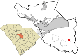 Location in Richland County and the state of South Carolina. | |
| Coordinates: 33°52′39″N 80°41′41″W / 33.87750°N 80.69472°WCoordinates: 33°52′39″N 80°41′41″W / 33.87750°N 80.69472°W | |
| Country | United States |
| State | South Carolina |
| County | Richland |
| Area | |
| • Total | 1.2 sq mi (3.1 km2) |
| • Land | 1.2 sq mi (3.1 km2) |
| • Water | 0 sq mi (0 km2) |
| Elevation | 190 ft (58 m) |
| Population (2010) | |
| • Total | 813 |
| • Density | 680/sq mi (260/km2) |
| Time zone | UTC-5 (EST) |
| • Summer (DST) | UTC-4 (EDT) |
| ZIP code | 29044 |
| Area code(s) | 803 |
| FIPS code | 45-22390[1] |
| GNIS feature ID | 1222202[2] |
| Website |
www |
Eastover is a town in Richland County, South Carolina, United States. The population was 813 at the 2010 census,[3] down from 830 in 2000. It is part of the Columbia, South Carolina, Metropolitan Statistical Area.
History
The J.A. Byrd Mercantile Store, Farmers and Merchants Bank Building, Good Hope Baptist Church, Goodwill Plantation, Kensington Plantation House, St. Phillip School, Saint Thomas' Protestant Episcopal Church, Claudius Scott Cottage, and Siloam School are listed on the National Register of Historic Places.[4]
Geography
Eastover is located at 33°52′39″N 80°41′41″W / 33.87750°N 80.69472°W (33.877553, -80.694592).[5]
According to the United States Census Bureau, the town has a total area of 1.2 square miles (3.1 km2), all land.[3]
Demographics
| Historical population | |||
|---|---|---|---|
| Census | Pop. | %± | |
| 1910 | 237 | — | |
| 1920 | 326 | 37.6% | |
| 1930 | 393 | 20.6% | |
| 1940 | 473 | 20.4% | |
| 1950 | 564 | 19.2% | |
| 1960 | 713 | 26.4% | |
| 1970 | 817 | 14.6% | |
| 1980 | 899 | 10.0% | |
| 1990 | 1,044 | 16.1% | |
| 2000 | 830 | −20.5% | |
| 2010 | 813 | −2.0% | |
| Est. 2016 | 809 | [6] | −0.5% |
| U.S. Decennial Census[7] | |||
At the 2000 census,[1] there were 830 people, 307 households and 228 families residing in the town. The population density was 670.8 per square mile (258.4/km²). There were 357 housing units at an average density of 288.5 per square mile (111.2/km²). The racial makeup of the town was 92.26% African American, 6.87% White, 0.41% Asian, 0.12% from other races, and 0.48% from two or more races. Hispanic or Latino of any race were 0.24% of the population.
There were 307 households of which 39.4% had children under the age of 18 living with them, 26.4% were married couples living together, 43.0% had a female householder with no husband present, and 25.7% were non-families. 23.5% of all households were made up of individuals and 9.4% had someone living alone who was 65 years of age or older. The average household size was 2.64 and the average family size was 3.07.
32.4% of the population were under the age of 18, 10.6% from 18 to 24, 24.7% from 25 to 44, 21.7% from 45 to 64, and 10.6% who were 65 years of age or older. The median age was 32 years. For every 100 females, there were 81.2 males. For every 100 females age 18 and over, there were 67.0 males.
The median household income was $20,114 and the median family income was $19,844. Males had a median income of $23,250 versus $17,875 for females. The per capita income for the town was $9,304. About 36.9% of families and 37.3% of the population were below the poverty line, including 53.1% of those under age 18 and 30.0% of those age 65 or over.
Education
Richland County School District One operates area public schools.
Webber Elementary School is in Eastover.[8] Eastover is zoned to Webber Elementary, Southeast Middle School, and Lower Richland High School.[9]
Points of interest
Eastover is the site of McEntire Joint National Guard Base and the headquarters for the South Carolina Air National Guard.
South Carolina Electric & Gas Company's Wateree Station 700 megawatt coal power plant is located here.
South Carolina's only national park, the Congaree National Park, is twelve miles southwest of Eastover. Eastover is the closest municipality to the park.
Notable people
Politics
Eastover is in South Carolina's 6th congressional district.
References
- 1 2 "American FactFinder". United States Census Bureau. Archived from the original on 2013-09-11. Retrieved 2008-01-31.
- ↑ "US Board on Geographic Names". United States Geological Survey. 2007-10-25. Retrieved 2008-01-31.
- 1 2 "Geographic Identifiers: 2010 Demographic Profile Data (G001): Eastover town, South Carolina". U.S. Census Bureau, American Factfinder. Retrieved January 14, 2013.
- ↑ National Park Service (2010-07-09). "National Register Information System". National Register of Historic Places. National Park Service.
- ↑ "US Gazetteer files: 2010, 2000, and 1990". United States Census Bureau. 2011-02-12. Retrieved 2011-04-23.
- ↑ "Population and Housing Unit Estimates". Retrieved June 9, 2017.
- ↑ "Census of Population and Housing". Census.gov. Archived from the original on May 12, 2015. Retrieved June 4, 2015.
- ↑ "Home." Webber Elementary School. Retrieved on December 10, 2016. "Address 140 Webber School Road, Eastover, SC 29044"
- ↑ "RichlandOneSCPlotMaps150323.pdf." Richland County School District One. Retrieved on December 10, 2016.
External links
Municipalities and communities of Richland County, South Carolina, United States | ||
|---|---|---|
| Cities |  | |
| Towns | ||
| CDPs | ||
| Unincorporated communities | ||
| Footnotes | ‡This populated place also has portions in an adjacent county or counties | |