Gleizé
| Gleizé | |
|---|---|
| Commune | |
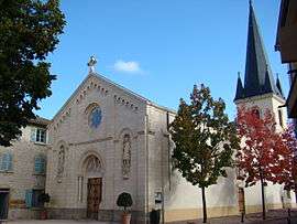 The church in Gleizé | |
 Gleizé Location within Auvergne-Rhône-Alpes region  Gleizé | |
| Coordinates: 45°59′24″N 4°41′51″E / 45.99°N 4.6975°ECoordinates: 45°59′24″N 4°41′51″E / 45.99°N 4.6975°E | |
| Country | France |
| Region | Auvergne-Rhône-Alpes |
| Department | Rhône |
| Arrondissement | Villefranche-sur-Saône |
| Canton | Gleizé |
| Intercommunality | Villefranche Beaujolais Saône |
| Government | |
| • Mayor (2008–2014) | Elisabeth Lamure |
| Area1 | 10.46 km2 (4.04 sq mi) |
| Population (2006)2 | 7,807 |
| • Density | 750/km2 (1,900/sq mi) |
| Time zone | UTC+1 (CET) |
| • Summer (DST) | UTC+2 (CEST) |
| INSEE/Postal code | 69092 /69400 |
| Elevation |
181–292 m (594–958 ft) (avg. 234 m or 768 ft) |
|
1 French Land Register data, which excludes lakes, ponds, glaciers > 1 km2 (0.386 sq mi or 247 acres) and river estuaries. 2 Population without double counting: residents of multiple communes (e.g., students and military personnel) only counted once. | |
Gleizé is a commune in the Rhône department in eastern France.
See also
References
| Wikimedia Commons has media related to Gleizé. |
This article is issued from
Wikipedia.
The text is licensed under Creative Commons - Attribution - Sharealike.
Additional terms may apply for the media files.