Garrett County, Maryland
| Garrett County, Maryland | |||
|---|---|---|---|
| County | |||
| Garrett County | |||
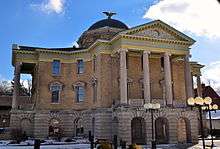 Garrett County Courthouse in December 2013 | |||
| |||
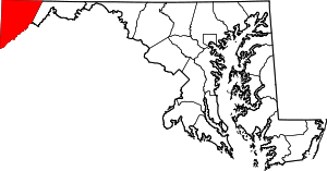 Location in the U.S. state of Maryland | |||
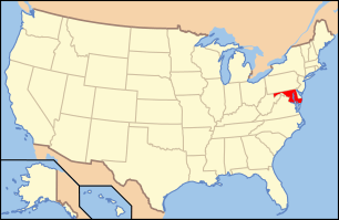 Maryland's location in the U.S. | |||
| Founded | November 4, 1872 | ||
| Named for | John Work Garrett | ||
| Seat | Oakland | ||
| Largest town | Mountain Lake Park | ||
| Area | |||
| • Total | 656 sq mi (1,699 km2) | ||
| • Land | 647 sq mi (1,676 km2) | ||
| • Water | 8.6 sq mi (22 km2), 1.3% | ||
| Population (est.) | |||
| • (2017) | 29,233 | ||
| • Density | 45/sq mi (17/km2) | ||
| Congressional district | 6th | ||
| Time zone | Eastern: UTC−5/−4 | ||
| Website |
www | ||


Garrett County (gərɛt) is the westernmost county of the U.S. state of Maryland. As of the 2010 census, the population was 30,097,[1] making it the third-least populous county in Maryland. Its county seat is Oakland.[2] The county was named for John Work Garrett (1820–1884), president of the Baltimore and Ohio Railroad.[3] Created from Allegany County, Maryland in 1872, it was the last Maryland county to be formed.
Garrett County has long been part of the media market of Pittsburgh, Pennsylvania.[4] It is considered to be a part of Western Maryland.
The Commonwealth of Pennsylvania is to the north. The Maryland–Pennsylvania boundary is commonly known as the Mason–Dixon line.[5] The eastern border with Allegany County was defined by the Bauer Report, submitted to Governor Lloyd Lowndes, Jr. on November 9, 1898.[6] The Potomac River and State of West Virginia lie to the south and west.
Garrett County lies in the Allegheny Mountains, which here form the western flank of the Appalachian Mountain Range. Hoye-Crest, a summit along Backbone Mountain, is the highest point in Maryland.
The Eastern Continental Divide runs along portions of Backbone Mountain. The western part of the county, drained by the Youghiogheny River, is the only part of Maryland within the Mississippi River drainage basin. All other parts of the county are in the Chesapeake Bay basin.
The National Register of Historic Places listings in Garrett County, Maryland has 20 National Register of Historic Places[7] properties and districts, including Casselman Bridge, National Road a National Historic Landmark. Garrett County is part of Maryland's 6th congressional district. The extreme south of the county lies within the United States National Radio Quiet Zone.
History
In the early 20th century, the railroad and tourism started to decline. Coal mining and timber production continued at a much slower pace. Today, tourism has made a dramatic rebound in the county with logging and farming making up the greatest part of the economic base. Due to a cool climate and lack of any large city, Garrett County has remained a sparsely populated rural area.
Geography
According to the U.S. Census Bureau, the county has a total area of 656 square miles (1,700 km2), of which 647 square miles (1,680 km2) is land and 8.6 square miles (22 km2) (1.3%) is water.[8] It is the second-largest county in Maryland by land area.
Garrett County is Maryland's westernmost, bordered to the north by the Mason–Dixon line with Pennsylvania, to the south and west by West Virginia (with the Potomac River forming its southern boundary), and to the east by a land border with Allegany County, Maryland. The county's northwesternmost point is approximately 60 miles (97 km) southeast of Pittsburgh, Pennsylvania, and its southeasternmost point is approximately 160 miles (260 km) northwest of Baltimore, Maryland.
Garrett County is located entirely within the highland zone of the Appalachian Mountains known variously as the Allegheny Mountains, the Allegheny Plateau, and the Appalachian Plateau. The county's highest elevations are located along four flat-topped ridges and range to a height of 3,360 feet (1,020 m) at Hoye-Crest along Backbone Mountain, the highest point in the state of Maryland. As is typical in the Allegheny region, broad flats generally lie below the ridge crests at elevations of approximately 500 feet (150 m). River valleys are generally narrow and deep, with ravines typically 1,000 to 1,800 feet (550 m) below surrounding peaks.
The county contains over 76,000 acres (310 km2) of parks, lakes, and publicly accessible forestland. It is drained by two river systems, the Potomac and the Youghiogheny. The Savage River, a tributary of the Potomac, drains about a third of the county. The Casselman River, a tributary of the Youghiogheny, flows north from the county's central section into Pennsylvania. The Youghiogheny itself drains the westernmost area of the county and flows north into Pennsylvania, where it empties into the Monongahela River at McKeesport, just south of Pittsburgh.[9]
Geologic points of interest
The Glades
The Glades' 601 acres (2.43 km2) is of great scientific interest because it is an ombrotrophic system (fed solely by rainwater) with peat layers up to 9 feet (2.7 m) thick, and is one of the oldest examples of mountain peatland in the Appalachians.[10]
On the western edge of the Savage River State Forest along Maryland Route 495 lies Bittinger, Maryland. Named after Henry Bittinger who first settled in the area, other German settlers moved in and took up the fertile farm land. On the eastern edge of Bittinger is one of the largest glades area of Garrett County. Geographically, this is an area which seems to have been affected by the last great ice sheet of North America. Two miles southeast of Bittinger, there is a large deposit of peat moss.
Loess Dunes
In the Casselman River valley, 1-mile (1.6 km) south of Grantsville, Maryland and beside Maryland Route 495, one can see remains of geological evidence about the last great ice sheet over North America. A series of low mounds can be seen in the fields on the west side of Maryland Route 495 that are "loess" (wind-blown) material. Apparently, these are the only ones still visible in the northern part of Garrett County.
The mounds were formed when a glacier lake existed in the Casselman valley, and the ice around the edges of the frozen lake melted. Wind blew fine grains of earth into the water around the edges where it sank to the bottom, and the mounds were the result of the deposit of this wind-blown material.
Mountains
|
Creeks
Lakes
Waterfalls
|
Forests, rivers, caves
See these articles for information on the forests, rivers and caves of Garrett County:
- List of Maryland state forests
- List of rivers of Maryland
- Caves of Maryland (Crabtree - largest cave in Maryland)
Parks and recreation

Garrett County contains over 76,000 acres (310 km2) of parks, lakes, and publicly accessible forestland. Popular activities in the county include camping, hiking, backpacking, rock climbing, alpine and cross county skiing, snowmobiling, hunting, ice fishing, fly fishing, whitewater canoeing, kayaking, rafting, boating, swimming, sailing, horseback riding, and water skiing.[15]
State parks
There are seven state parks in Garrett County. All offer picnic and fishing areas; all but Casselman River State Park have hiking paths. Mountain bike paths, swimming areas, and boat launches and rentals are available at Deep Creek, Herrington Manor, and New Germany state parks. Rental cabins are available at Herrington Manor and New Germany state parks. Big Run, Deep Creek, Herrington Manor and New Germany state parks all offer canoeing, while campsites may be found at Big Run, Deep Creek, New Germany, and Swallow Falls state parks.[16]
- Big Run State Park
- Casselman River Bridge State Park (Grantsville)
- Deep Creek Lake State Park (Swanton)
- Herrington Manor State Park (Oakland)
- New Germany State Park (Grantsville)
- Sang Run State Park [17]
- Swallow Falls State Park
County parks
Garrett County owns four park sites and fifteen recreation facilities. The parks are maintained in cooperation with local associations and civic groups. The recreation areas are attached to public schools and colleges and maintained by the Garrett County Board of Education.[18]
Municipal parks
The municipal parks of Garrett County provide sport facilities, hiking, bike and walk paths, playgrounds, picnic areas, boat ramps, and fishing.[19]
- Kitzmiller Parks & Recreation Dept.
- Oakland Broadford Park includes swimming, picnic tables, fishing, boat ramp, playgrounds, sports fields.
Adjacent counties
- Somerset County, Pennsylvania (north)
- Allegany County, Maryland (east)
- Mineral County, West Virginia (southeast)
- Grant County, West Virginia (south)
- Preston County, West Virginia (west)
- Fayette County, Pennsylvania (northwest)
- Tucker County, West Virginia (southwest)
Demographics
| Historical population | |||
|---|---|---|---|
| Census | Pop. | %± | |
| 1880 | 12,175 | — | |
| 1890 | 14,213 | 16.7% | |
| 1900 | 17,701 | 24.5% | |
| 1910 | 20,105 | 13.6% | |
| 1920 | 19,678 | −2.1% | |
| 1930 | 19,908 | 1.2% | |
| 1940 | 21,981 | 10.4% | |
| 1950 | 21,259 | −3.3% | |
| 1960 | 20,420 | −3.9% | |
| 1970 | 21,476 | 5.2% | |
| 1980 | 26,498 | 23.4% | |
| 1990 | 28,138 | 6.2% | |
| 2000 | 29,846 | 6.1% | |
| 2010 | 30,097 | 0.8% | |
| Est. 2017 | 29,233 | [20] | −2.9% |
| U.S. Decennial Census[21] 1790-1960[22] 1900-1990[23] 1990-2000[24] | |||
2000 census
As of the census[25] of 2000, there were 29,846 people, 11,476 households, and 8,354 families residing in the county. The population density was 18/km² (46/sq mi). There were 16,761 housing units at an average density of 10/km² (26/sq mi). The racial makeup of the county was 98.83% White, 0.43% Black or African American, 0.07% Native American, 0.19% Asian, 0.02% Pacific Islander, 0.09% from other races, and 0.37% from two or more races. 0.44% of the population were Hispanic or Latino of any race. 36.1% were of German, 22.9% identified as American, 9.6% English and 8.8% Irish ancestry.
There were 11,476 households out of which 32.60% had children under the age of 18 living with them, 60.70% were married couples living together, 8.40% had a female householder with no husband present, and 27.20% were non-families. 23.50% of all households were made up of individuals and 10.60% had someone living alone who was 65 years of age or older. The average household size was 2.55 and the average family size was 3.00.
In the county, the population was spread out with 25.10% under the age of 18, 7.80% from 18 to 24, 27.60% from 25 to 44, 24.60% from 45 to 64, and 14.90% who were 65 years of age or older. The median age was 38 years. For every 100 females there were 97.20 males. For every 100 females age 18 and over, there were 93.80 males.
The median income for a household in the county was $32,238, and the median income for a family was $37,811. Males had a median income of $29,469 versus $20,673 for females. The per capita income for the county was $16,219. 13.30% of the population and 9.80% of families were below the poverty line. Out of the total people living in poverty, 16.60% are under the age of 18 and 13.90% are 65 or older.
2010 census
As of the 2010 United States Census, there were 30,097 people, 12,057 households, and 8,437 families residing in the county.[26] The population density was 46.5 inhabitants per square mile (18.0/km2). There were 18,854 housing units at an average density of 29.1 per square mile (11.2/km2).[27] The racial makeup of the county was 97.8% white, 1.0% black or African American, 0.3% Asian, 0.1% American Indian, 0.1% from other races, and 0.7% from two or more races. Those of Hispanic or Latino origin made up 0.7% of the population.[26] In terms of ancestry, 35.4% were German, 13.6% identified as American, 11.3% were Irish, and 11.3% were English.[28]
Of the 12,057 households, 30.0% had children under the age of 18 living with them, 56.4% were married couples living together, 9.3% had a female householder with no husband present, 30.0% were non-families, and 25.5% of all households were made up of individuals. The average household size was 2.45 and the average family size was 2.92. The median age was 42.7 years.[26]
The median income for a household in the county was $45,760 and the median income for a family was $56,545. Males had a median income of $40,035 versus $27,325 for females. The per capita income for the county was $23,888. About 8.9% of families and 12.5% of the population were below the poverty line, including 19.2% of those under age 18 and 12.1% of those age 65 or over.[29]
Garrett County is home to an Amish community in the Oakland area that consists of a church district of about 70 homes. The Amish community dates back to 1850 and became associated with the New Order Amish, with electricity permitted inside of homes.[30]
Law and government
Government
The County is governed by an elected three-member Board of County Commissioners, whose members serve four-year terms and must live in the district they represent. The Board is the traditional form of county government in Maryland. It may exercise only those powers conferred by the General Assembly of Maryland,[31] and even those powers are narrowly construed.
Garrett County is administered under a line organizational method, with the County Administrator responsible for the general administration of County Government. The administration of the County is centralized with the County Administrator responsible for overseeing the financial planning, annual budget process, personnel management, and direction and management of operations within the organization.[31]
County seal
On December 15, 1977, the seal[6] of Garrett County went into effect by virtue of Resolution #7. The seal is elliptical, with the name "Garrett County" inscribed above the upper fourth of the ellipse, and "Maryland 1872" inscribed below the lower fourth of the ellipse. The date "1872" depicts the year of the formation of Garrett County. The seal illustrates a large snowflake to depict winter; water to represent sailing; and oaks and conifer to represent the county's mountains. The colors are peacock blue for the sky and water. The blue and white background is divided by kelly green.
County flag
The official flag[6] for Garrett County is elliptical. The flag illustrates a large snowflake to depict winter; water to represent sailing; and oaks and conifer to represent the county's mountains. The colors are peacock blue for the sky and water. The blue and white background is divided by kelly green.
Politics
Although since the Civil War Maryland has been a Democratic-leaning state, Garrett County, owing to its history of German settlement from north of the Mason–Dixon line, plus strong pre-war Unionism resulting from virtual absence of slaves,[32] has always been strongly Republican. Since it was created in 1872, Garrett is one of forty counties across the nation (chiefly Unionist strongholds in antebellum slave states) to have never voted for a Democratic presidential candidate.[33][34] Compared with neighbouring and closely allied Grant County, West Virginia, Garrett has not shown quite the same levels of Republican support – Lyndon Johnson did get within 109 votes of Barry Goldwater in 1964 – but as with Grant County, the only occasion Garrett County has not been carried by the official Republican nominee occurred in 1912 when a major split in the Republican Party allowed "Bull Moose Party" nominee and former President Theodore Roosevelt to claim the county.
| Year | Republican | Democratic | Third parties |
|---|---|---|---|
| 2016 | 76.9% 10,776 | 18.3% 2,567 | 4.8% 668 |
| 2012 | 74.1% 9,743 | 23.7% 3,124 | 2.2% 290 |
| 2008 | 69.2% 8,903 | 29.0% 3,736 | 1.8% 233 |
| 2004 | 72.8% 9,085 | 26.4% 3,291 | 0.9% 108 |
| 2000 | 70.5% 7,514 | 27.0% 2,872 | 2.5% 269 |
| 1996 | 55.2% 5,400 | 31.9% 3,121 | 12.9% 1,265 |
| 1992 | 54.0% 5,714 | 27.0% 2,856 | 19.0% 2,010 |
| 1988 | 71.8% 6,665 | 27.6% 2,557 | 0.7% 60 |
| 1984 | 74.3% 7,042 | 25.2% 2,386 | 0.5% 49 |
| 1980 | 64.1% 5,475 | 31.7% 2,708 | 4.2% 362 |
| 1976 | 58.2% 4,640 | 41.8% 3,332 | |
| 1972 | 76.6% 5,480 | 21.1% 1,510 | 2.3% 164 |
| 1968 | 59.4% 4,021 | 28.5% 1,933 | 12.1% 818 |
| 1964 | 50.8% 3,624 | 49.2% 3,515 | |
| 1960 | 68.2% 5,057 | 31.8% 2,357 | |
| 1956 | 73.1% 5,555 | 26.9% 2,045 | |
| 1952 | 68.4% 4,980 | 31.3% 2,281 | 0.3% 18 |
| 1948 | 64.3% 3,536 | 34.7% 1,909 | 0.9% 51 |
| 1944 | 68.0% 4,162 | 32.0% 1,961 | |
| 1940 | 60.7% 4,387 | 38.8% 2,805 | 0.5% 38 |
| 1936 | 55.0% 4,057 | 44.1% 3,252 | 0.9% 64 |
| 1932 | 56.0% 3,048 | 41.0% 2,232 | 3.0% 163 |
| 1928 | 78.4% 4,371 | 20.9% 1,168 | 0.7% 38 |
| 1924 | 61.8% 2,594 | 29.2% 1,226 | 9.0% 378 |
| 1920 | 70.3% 2,805 | 26.8% 1,070 | 3.0% 118 |
| 1916 | 61.2% 1,808 | 34.9% 1,031 | 3.9% 115 |
| 1912 | 22.4% 655 | 34.4% 1,005 | 43.2% 1,260 |
| 1908 | 62.0% 2,055 | 33.8% 1,121 | 4.2% 140 |
| 1904 | 67.0% 2,051 | 30.9% 947 | 2.1% 65 |
| 1900 | 63.1% 2,259 | 35.8% 1,283 | 1.1% 38 |
Law enforcement
The county is policed by the Garrett County Sheriff's Office and the Maryland State Police.
The state parks are policed by the Department of Natural Resources Police.
Economy
Garrett County produces natural gas, the only county in the state to do so.[15] Much of the economic activity in the area centers around the outdoors. In the winter, the Wisp ski resort in Oakland and New Germany State Park's cross county skiing trail are frequent destinations, and Deep Creek Lake sees much activity in the summer. The state parks in the county are frequented year-round.
Transportation
Major highways

Airport
Garrett County Airport (2G4) is a general aviation airport surrounded by the mountains of Western Maryland. The airport enhances the region's tourist industry and provides emergency air service evacuation and landing facilities for general aviation.[36]
Media
Garrett County is part of the Pittsburgh, Pennsylvania television market. Cable and satellite are all but essential for acceptable television due to the county's rugged terrain.
It has a weekly newspaper, the Garrett County Republican, which was purchased by NCWV Media in 2017[37].
Events
Annual events include the Autumn Glory Festival, the Scottish Highland Festival, and the Garrett County Fair.
Communities

Towns
Census-designated places
The United States Census Bureau recognizes seven census-designated places (CDPs) in Garrett County.
Unincorporated communities
The following communities are classified as populated places or locales by the Geographic Names Information System.
- Altamont (39°25′39″N 79°16′55″W / 39.42750°N 79.28194°W) is where CSX's Mountain Subdivision rail line crosses the Eastern Continental Divide just west of the railroad's underpass of MD 135 east of Deer Park.
- Asher Glade (39°42′14″N 79°26′50″W / 39.70389°N 79.44722°W) is at the intersection of MD 42 and Asher Glade Road northwest of Friendsville and a short distance south of the Pennsylvania state line near Markleysburg, Pennsylvania.
- Avilton (39°39′01″N 79°02′32″W / 39.65028°N 79.04222°W) is at the intersection of Avilton Lonaconing Road and Green Lantern Road southwest of Finzel.
- Bethel (39°26′42″N 79°07′07″W / 39.44500°N 79.11861°W) is at the intersection of Walnut Bottom Road and Chestnut Grove Road near Jennings Randolph Lake southwest of Bloomington.
- Bevansville (39°39′15″N 79°11′34″W / 39.65417°N 79.19278°W) is at the intersection of MD 495 and Durst Road west of Jennings.
- Bittinger (39°36′08″N 79°13′24″W / 39.60222°N 79.22333°W) is at the intersection of MD 495 and Orendorf Road north of Swanton and south of Grantsville.
- Blooming Rose (39°39′24″N 79°26′21″W / 39.65667°N 79.43917°W) is at the intersection of MD 42 and Blooming Rose Road west of Friendsville.
- Casselman (39°40′31″N 79°10′18″W / 39.67528°N 79.17167°W) is at the intersection of MD 495 and Maple Grove Road along the Casselman River south of Grantsville.
- Cove (39°40′49″N 79°18′00″W / 39.68028°N 79.30000°W) is at the intersection of Cove Road and Cove Run north of Accident.
- East Vindex (39°25′04″N 79°11′14″W / 39.41778°N 79.18722°W) is on Vindex Road north of Kitzmiller.
- Elder Hill (39°37′28″N 79°23′28″W / 39.62444°N 79.39111°W) is at the intersection of MD 42 and Kisner Road south of Friendsville.
- Engle Mill (39°38′49″N 79°17′11″W / 39.64694°N 79.28639°W) is at the intersection of Fish Hatchery Road and Bowman Hill Road northeast of Accident.
- Fairview (39°35′36″N 79°08′46″W / 39.59333°N 79.14611°W) is at the intersection of Fairview Road and Peapatch Lane south of Grantsville.
- Floyd (39°30′15″N 79°09′20″W / 39.50417°N 79.15556°W) is at the intersection of Savage River Road and Spring Lick Road west of Bloomington.
- Fort Pendleton (39°17′43″N 79°22′27″W / 39.29528°N 79.37417°W) is on US 50 west of Gorman and east of Backbone Mountain.
- Foxtown (39°37′57″N 79°14′18″W / 39.63250°N 79.23833°W) is at the intersection of Dung Hill Road and Amish Road west of Jennings.
- Fricks Crossing (39°24′41″N 79°20′00″W / 39.41139°N 79.33333°W) is where Fricks Crossing Road intersects CSX's Mountain Subdivision rail line and crosses the Little Youghiogheny River southwest of Deer Park.
- Gortner (39°21′18″N 79°25′39″W / 39.35500°N 79.42750°W) is at the intersection of US 219 and Mason School Road south of Oakland.
- Gravel Hill (39°39′50″N 79°23′35″W / 39.66389°N 79.39306°W) is on Friendsville Addison Road east of Friendsville.
- Green Glade (39°28′26″N 79°15′53″W / 39.47389°N 79.26472°W) is on Green Glade Road along the south side of Green Glade Cove, a branch of Deep Creek Lake.
- Hazelhurst (39°28′13″N 79°16′17″W / 39.47028°N 79.27139°W) is on Hazelhurst Road along the south side of Green Glade Cove, a branch of Deep Creek Lake.
- Herrington Manor (39°27′10″N 79°27′11″W / 39.45278°N 79.45306°W) is the location of Herrington Manor State Park northwest of Oakland.
- Hi-Point (39°42′21″N 79°12′38″W / 39.70583°N 79.21056°W) is where US 40 Alternate crosses the top of Negro Mountain west of Grantsville. This location was the highest point on the National Road.
- High Point (39°41′41″N 79°06′15″W / 39.69472°N 79.10417°W) is at the intersection of US 40 Alternate and US 219 east of Grantsville.
- Hoyes (39°35′25″N 79°22′10″W / 39.59028°N 79.36944°W) is at the intersection of MD 42 and Hoyes Sang Run Road southwest of Accident.
- Hoyes Run (39°31′41″N 79°24′38″W / 39.52806°N 79.41056°W) is at the intersection of Oakland Sang Run Road and Hoyes Run Road along the Youghiogheny River west of Deep Creek Lake.
- Kaese Mill (39°39′01″N 79°17′46″W / 39.65028°N 79.29611°W) is at the intersection of Collier Road and Fish Hatchery Road east of US 219's junction with Fish Hatchery Road and northeast of Accident.
- Kearney (39°20′35″N 79°19′20″W / 39.34306°N 79.32222°W) is at the intersection of White Church Steyer Road and Le Moyne King Road southeast of Loch Lynn Heights.
- Keeler Glade (39°37′46″N 79°28′40″W / 39.62944°N 79.47778°W) is along Blooming Rose Road just east of the Maryland–West Virginia state line.
- Kempton (39°12′24″N 79°29′07″W / 39.20667°N 79.48528°W) is on Kempton Road next to the Potomac River in the southwestern corner of Garrett County where the Maryland–West Virginia state line changes from the river to a north–south line.
- Kendall (39°38′00″N 79°25′03″W / 39.63333°N 79.41750°W) is on the Youghiogheny River south of Friendsville and north of Sang Run.
- Keysers Ridge (39°41′37″N 79°14′53″W / 39.69361°N 79.24806°W) is at the junctions of I-68, US 40, US 219, and US 40 Alternate west of Grantsville.
- Lake Ford (39°31′36″N 79°28′48″W / 39.52667°N 79.48000°W) is at the intersection of Cranesville Road and Lake Ford Road south of the Cranesville Swamp Preserve just east of the Maryland–West Virginia state line.
- Locust Grove (39°39′12″N 79°27′34″W / 39.65333°N 79.45944°W) is at the intersection of Noah Frazee Road and Sand Spring Road west of Friendsville.
- McComas Beach (39°30′06″N 79°22′23″W / 39.50167°N 79.37306°W) is on Mayhew Inn Road along Red Run Cove near the west end of Deep Creek Lake.
- McHenry (39°33′30″N 79°21′10″W / 39.55833°N 79.35278°W) is at the intersection of US 219 and Mosser Road on March Run Cove at the north end of Deep Creek Lake.
- Merrill (39°35′56″N 79°04′59″W / 39.59889°N 79.08306°W) is where Westernport Road crosses the Savage River within Savage River State Forest west of Lonaconing.
- Mineral Spring (39°42′29″N 79°21′01″W / 39.70806°N 79.35028°W) is at the confluence of Mill Run and Cove Run east of Youghiogheny River Lake northeast of Friendsville.
- Mitchell Manor (39°25′07″N 79°23′46″W / 39.41861°N 79.39611°W) is a neighborhood east of Cherry Glade Run just north of the town of Oakland.
- New Germany (39°37′57″N 79°07′20″W / 39.63250°N 79.12222°W) is along New Germany Road adjacent to New Germany State Park south of Grantsville.
- North Glade (39°30′03″N 79°14′12″W / 39.50083°N 79.23667°W) is at the intersection of MD 495 and North Glade Road east of Deep Creek Lake.
- Piney Grove (39°41′05″N 79°04′23″W / 39.68472°N 79.07306°W) is at the intersection of US 40 Alternate and Avilton Lonaconing Road.
- Redhouse (39°18′31″N 79°27′14″W / 39.30861°N 79.45389°W) is at the intersection of US 50 and US 219 south of Oakland and west of Backbone Mountain.
- Ryan's Glade stretches along the common border with Grant County, West Virginia from about midway between Mountain Lake Park and Gormania to the southwestern corner of the county near Wilsonia.[38]
- Sand Spring (39°40′21″N 79°27′34″W / 39.67250°N 79.45944°W) is at the intersection of Sand Spring Road and Fearer Road west of Friendsville.
- Sang Run (39°34′05″N 79°25′21″W / 39.56806°N 79.42250°W) is at the intersection of Sang Run Road and Oakland Sang Run Road west of McHenry
- Schell (39°20′31″N 79°15′35″W / 39.34194°N 79.25972°W) is at the confluence of Laurel Run and the Potomac River northeast of Gorman.
- Selbysport (39°41′11″N 79°22′49″W / 39.68639°N 79.38028°W) is at the intersection of Friendsville Addison Road and Old Morgantown Road north of Friendsville.
- Shallmar (39°22′46″N 79°12′17″W / 39.37944°N 79.20472°W) is along Shallmar Road along the Potomac River west of Kitzmiller.
- Standard (39°24′54″N 79°10′31″W / 39.41500°N 79.17528°W) is at the confluence of Three Forks Run and the Potomac River north of Kitzmiller.
- Stanton Mill (39°42′04″N 79°08′13″W / 39.70111°N 79.13694°W) is where River Road crosses the Casselman River east of Grantsville.
- Steyer (39°18′20″N 79°18′39″W / 39.30556°N 79.31083°W) is at the intersection of White Church Steyer Road and Steyer Gorman Road near the Potomac River east of Gorman.
- Strawn (39°43′16″N 79°17′48″W / 39.72111°N 79.29667°W) is along US 40 just south of the Maryland–Pennsylvania state line west of Keysers Ridge. Formerly known as Oakton.[39]
- Strecker (39°28′30″N 79°11′27″W / 39.47500°N 79.19083°W) is along Crabtree Creek and CSX's Mountain Subdivision between Swanton and Savage River Reservoir.
- Sunnyside (39°20′25″N 79°26′49″W / 39.34028°N 79.44694°W) is at the intersection of US 219 and Ben Dewitt Road north of Redhouse.
- Table Rock (39°18′05″N 79°25′02″W / 39.30139°N 79.41722°W) is at the intersection of US 50 and Table Rock Road on top of Backbone Mountain.
- Tasker Corners (39°21′44″N 79°17′39″W / 39.36222°N 79.29417°W) is at the junctions of Bethlehem Road, Steyer Mine Road, Schell Road, and Potomac Camp Road southeast of Loch Lynn Heights and southwest of Kitzmiller.
- Thayerville (39°30′06″N 79°19′36″W / 39.50167°N 79.32667°W) is at the intersection of US 219 and Glendale Road next to Deep Creek Lake.
- Wallman (39°19′01″N 79°17′02″W / 39.31694°N 79.28389°W) is along Wallman Road along the Potomac River northeast of Gorman.
- West Vindex (39°25′03″N 79°12′20″W / 39.41750°N 79.20556°W) is along Vindex Road north of Kitzmiller.
- There are two locations named Wilson:
- One Wilson (39°25′56″N 79°16′13″W / 39.43222°N 79.27028°W) is along Old Wilson Road at the source of the South Fork of Crabtree Creek east of Altamont.
- The other Wilson (39°15′15″N 79°23′52″W / 39.25417°N 79.39778°W) is in both Maryland and West Virginia on either side of the Wilson Bridge across the Potomac River southwest of Gorman.
- Winding Ridge (39°41′17″N 79°19′32″W / 39.68806°N 79.32556°W) is at the intersection of Cove Road and Old Morgantown Road north of Accident.
Education
Garrett County Public Schools operates public schools.
See also
References
- ↑ "State & County QuickFacts". United States Census Bureau. Archived from the original on July 10, 2011. Retrieved August 24, 2013.
- ↑ "Find a County". National Association of Counties. Archived from the original on May 31, 2011. Retrieved June 7, 2011.
- ↑ "Maryland Counties, Garrett County, Maryland". Maryland Manual On-Line. Maryland State Archives. Retrieved 2009-11-11.
- ↑
- ↑ Cope, Thomas D (May 1949), Degrees along the west line, the parallel between Maryland and Pennsylvania, Proceedings of the American Philosophical Society 93(2):127-133, American Philosophical Society
- 1 2 3 "Title 1: General Provisions". Garrett County, MD Code of Ordinances. American Legal Publishing Corporation. Archived from the original on 2009-10-31. Retrieved 2009-11-11.
- ↑ National Park Service (2008-04-15). "National Register Information System". National Register of Historic Places. National Park Service.
- ↑ "2010 Census Gazetteer Files". United States Census Bureau. August 22, 2012. Archived from the original on September 13, 2014. Retrieved September 12, 2014.
- ↑ Gary B. Blank, Ph.D. Associate professor, Department of Forestry. Maryland Department of Natural Resources, ed. "Forest Management History in the Central Appalachians 1900 to 2000" (PDF). Raleigh, NC: Department of Forestry, North Carolina State University. Archived from the original (PDF) on 2011-04-19. Retrieved 2009-11-27.
- ↑ "The Glades". Maryland. The Nature Conservancy. Retrieved 2009-11-27.
- ↑ "Maryland at a Glance, Land, Mountains". Maryland Manual On-Line. Maryland State Archives. Retrieved 2009-11-11.
- ↑ "Maryland at a Glance, Waterways, Creeks". Maryland Manual On-Line. Maryland State Archives. Retrieved 2009-11-11.
- ↑ "Maryland at a Glance, Waterways, Lakes". Maryland Manual On-Line. Maryland State Archives. Retrieved 2009-11-11.
- ↑ "Maryland at a Glance, Waterways, Waterfalls". Maryland Manual On-Line. Maryland State Archives. Retrieved 2009-11-11.
- 1 2 "Garrett County". County Profiles. Maryland Department of Business and Economic Development. Archived from the original on 2009-03-27. Retrieved 2009-11-11.
- ↑ "Maryland at a Glance, Parks & Recreation, State Parks". Maryland Manual On-Line. Maryland State Archives. Retrieved 2009-11-11.
- ↑ "Sang Run State Park". Maryland Department of Natural Resources. Retrieved 2018-08-08.
- ↑ "Maryland at a Glance, Parks & Recreation, County Parks". Maryland Manual On-Line. Maryland State Archives. Retrieved 2009-11-11.
- ↑ "Maryland at a Glance, Parks & Recreation, Municipal Parks". Maryland Manual On-Line. Maryland State Archives. Retrieved 2009-11-11.
- ↑ "Population and Housing Unit Estimates". Retrieved March 30, 2018.
- ↑ "U.S. Decennial Census". United States Census Bureau. Archived from the original on May 12, 2015. Retrieved September 12, 2014.
- ↑ "Historical Census Browser". University of Virginia Library. Retrieved September 12, 2014.
- ↑ "Population of Counties by Decennial Census: 1900 to 1990". United States Census Bureau. Retrieved September 12, 2014.
- ↑ "Census 2000 PHC-T-4. Ranking Tables for Counties: 1990 and 2000" (PDF). United States Census Bureau. Retrieved September 12, 2014.
- ↑ "American FactFinder". United States Census Bureau. Archived from the original on 2013-09-11. Retrieved 2008-01-31.
- 1 2 3 "DP-1 Profile of General Population and Housing Characteristics: 2010 Demographic Profile Data". United States Census Bureau. Retrieved 2016-01-22.
- ↑ "Population, Housing Units, Area, and Density: 2010 - County". United States Census Bureau. Retrieved 2016-01-22.
- ↑ "DP02 SELECTED SOCIAL CHARACTERISTICS IN THE UNITED STATES – 2006-2010 American Community Survey 5-Year Estimates". United States Census Bureau. Retrieved 2016-01-22.
- ↑ "DP03 SELECTED ECONOMIC CHARACTERISTICS – 2006-2010 American Community Survey 5-Year Estimates". United States Census Bureau. Retrieved 2016-01-22.
- ↑ "Maryland Amish". Amish America. Retrieved October 6, 2017.
- 1 2 "Board of Garrett County Commissioners". Board of Commissioners. Garrett County Online. Archived from the original on 2010-10-21. Retrieved 2009-11-11.
- ↑ Levine, Mark V.; 'Standing Political Decisions and Critical Realignment: The Pattern of Maryland Politics, 1872-1948'; The Journal of Politics, volume 38, no. 2 (May, 1976), pp. 292-325
- ↑ DeLisio, James E.; Maryland Geography: An Introduction, p. 260 ISBN 1421414821
- ↑ Maxwell, Brandt; ‘A Few Lists of 2008 Election Results (Part II)’
- ↑ Leip, David. "Dave Leip's Atlas of U.S. Presidential Elections". uselectionatlas.org. Retrieved 2018-06-11.
- ↑ "Garrett County Airport (2G4)". FAA Information effective 22 October 2009. AirNav.com. Retrieved 2009-11-11.
- ↑ https://newsandtech.com/dateline/ncwv-media-buys-maryland-paper/article_b62d5820-70b8-11e7-b894-73c13ba26a6e.html
- ↑ "Ryan's Glade Election District". Garrett County.
- ↑ "Mason-Dixon Line: Milestone No. (206)" (PDF). Maryland Historic Trust.
External links
County, State and Federal government
- Garrett County Online
- Maryland State Archives - Maryland Manual, Garrett County
- Garrett County Economic Development Online
- U.S. Census Bureau State & County QuickFacts - Garrett County, Maryland
- Maryland Geological Survey Online
- U.S. Geological Survey - Geographic Names Information System (GNIS)
- State of Maryland Department of Natural Resources - Western Maryland Public Lands
- Maryland Land Conservation Center
- Garrett County Health Department
- Garrett County Community Planning Tool
Historical and academic
Business and tourism
- Deep Creek Lake Events, Business Listings and More
- The Official Website of Garrett County's Chamber of Commerce
- The Official Website of Garrett County's Deep Creek Lake Area
- The Official site of the Maryland Office of Tourism
- AirNav.com - Garrett County Airport (2G4)
- Garrett County Arts Council
- Deep Creek Times, Deep Creek Lake and Garrett County area information
- News - Oakland, The Republican
- News - Cumberland, Times-News
Places adjacent to Garrett County, Maryland | |
|---|---|
Municipalities and communities of Garrett County, Maryland, United States | ||
|---|---|---|
| Towns | | |
| CDPs | ||
| Unincorporated communities | ||
| Ghost town | ||
| Footnotes | ‡This populated place also has portions in an adjacent county or counties | |