Redhouse, Maryland
| Redhouse, Maryland | |
|---|---|
| Unincorporated community | |
 Red House  Red House | |
| Coordinates: 39°18.5′N 79°27.2′W / 39.3083°N 79.4533°WCoordinates: 39°18.5′N 79°27.2′W / 39.3083°N 79.4533°W | |
| Country | United States |
| State | Maryland |
| County | Garrett |
| Elevation | 2,543 ft (775 m) |
| Time zone | UTC-5 (Eastern (EST)) |
| • Summer (DST) | UTC-4 (EDT) |
| Area code(s) | 240 & 301 |
| GNIS feature ID | 586795[1] |
Redhouse[1] is an unincorporated community in Garrett County, Maryland, United States, located at the intersection of U.S. Route 50 and U.S. Route 219 near the West Virginia state line.
References
Municipalities and communities of Garrett County, Maryland, United States | ||
|---|---|---|
| Towns | 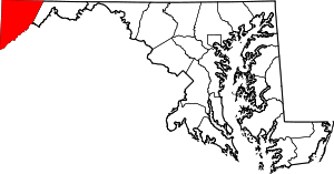 | |
| CDPs | ||
| Unincorporated communities | ||
| Ghost town | ||
| Footnotes | ‡This populated place also has portions in an adjacent county or counties | |
This article is issued from
Wikipedia.
The text is licensed under Creative Commons - Attribution - Sharealike.
Additional terms may apply for the media files.