Bloomington, Maryland
| Bloomington, Maryland | |
|---|---|
| Census-designated place | |
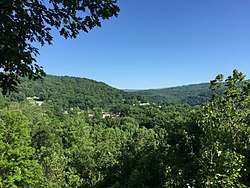 View of Bloomington from West Virginia Route 46 across the North Branch Potomac River in Mineral County, West Virginia | |
 Bloomington  Bloomington | |
| Coordinates: 39°28′48″N 79°4′16″W / 39.48000°N 79.07111°WCoordinates: 39°28′48″N 79°4′16″W / 39.48000°N 79.07111°W | |
| Country | United States |
| State | Maryland |
| County | Garrett |
| Area | |
| • Total | 0.64 sq mi (1.67 km2) |
| • Land | 0.62 sq mi (1.61 km2) |
| • Water | 0.02 sq mi (0.06 km2) |
| Elevation | 1,049 ft (320 m) |
| Population (2010) | |
| • Total | 305 |
| • Density | 492/sq mi (189.9/km2) |
| Time zone | UTC−5 (Eastern (EST)) |
| • Summer (DST) | UTC−4 (EDT) |
| ZIP code | 21523 |
| Area code(s) | 301 and 240 |
| FIPS code | 24-08050 |
| GNIS feature ID | 583295 |
Bloomington is an unincorporated community and census-designated place (CDP) at the confluence of the North Branch Potomac River and Savage River in southeastern Garrett County, Maryland, United States. It lies to the west of Luke on Maryland Route 135 and is bounded to the northwest by Savage River State Forest. As of the 2010 census the population of Bloomington was 305.[1]
Originally known as "Llangollen" when the town's post office was established on December 4, 1872, its name was later changed to "Bloomington". Jennings Randolph Lake to the southwest on the North Branch of the Potomac was completed in 1982 as "Bloomington Lake" but was renamed in 1987 by the United States Congress for West Virginia Senator Jennings Randolph.
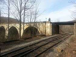
Borderside, a historic home, was listed on the National Register of Historic Places in 1975.[2] The Bloomington Viaduct was listed in 1976.[2]
A proposal has been filed with the Federal Energy Regulatory Commission by Fairlawn Hydroelectric Company to construct a 10.5 MW hydroelectric facility at the Army Corps of Engineers-operated dam for the lake.[3] Approvals were still pending in 2016.[4]
Climate
The climate in this area has mild differences between highs and lows, and there is adequate rainfall year-round. According to the Köppen Climate Classification system, Bloomington has a marine west coast climate, abbreviated "Cfb" on climate maps.[5]
References
- ↑ "Geographic Identifiers: 2010 Demographic Profile Data (G001): Bloomington CDP, Maryland". American Factfinder. U.S. Census Bureau. Retrieved December 15, 2016.
- 1 2 National Park Service (2008-04-15). "National Register Information System". National Register of Historic Places. National Park Service.
- ↑ Fairlawn Hydroelectric Company, LLC.; Notice of Intent To File License Application, 73 F.R. 30390 (May 27, 2008).
- ↑ "Order granting stay" (PDF). Federal Energy Regulatory Commission. Retrieved 15 July 2017.
- ↑ Climate Summary for Bloomington, Maryland
Municipalities and communities of Garrett County, Maryland, United States | ||
|---|---|---|
| Towns | 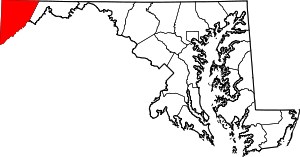 | |
| CDPs | ||
| Unincorporated communities | ||
| Ghost town | ||
| Footnotes | ‡This populated place also has portions in an adjacent county or counties | |