Gorman, Maryland
| Gorman, Maryland | |
|---|---|
| Census-designated place | |
 Gorman  Gorman | |
| Coordinates: 39°17′43″N 79°20′47″W / 39.29528°N 79.34639°WCoordinates: 39°17′43″N 79°20′47″W / 39.29528°N 79.34639°W | |
| Country | United States |
| State | Maryland |
| County | Garrett |
| Area | |
| • Total | 1.25 sq mi (3.25 km2) |
| • Land | 1.25 sq mi (3.25 km2) |
| • Water | 0.0 sq mi (0.0 km2) |
| Elevation | 2,320 ft (710 m) |
| Population (2010) | |
| • Total | 106 |
| • Density | 84/sq mi (33/km2) |
| Time zone | UTC-5 (Eastern (EST)) |
| • Summer (DST) | UTC-4 (EDT) |
| FIPS code | 24-34150 |
| GNIS feature ID | 590346 |
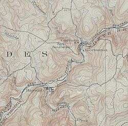
Gorman is a census-designated place (CDP) along the North Branch Potomac River in southern Garrett County, Maryland, United States. As of the 2010 census, Gorman's population was 106.[1] Gorman lies on Gorman Road (Maryland Route 560) off the Northwestern Turnpike (U.S. Route 50), which crosses the North Branch into Gormania, West Virginia, via Gormania Bridge. Like Gormania, the town is named for United States Senator from Maryland, Arthur Pue Gorman (March 11, 1839 – June 4, 1906).
References
- ↑ "Geographic Identifiers: 2010 Demographic Profile Data (G001): Gorman CDP, Maryland". American Factfinder. U.S. Census Bureau. Retrieved December 16, 2016.
Municipalities and communities of Garrett County, Maryland, United States | ||
|---|---|---|
| Towns | 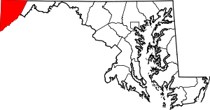 | |
| CDPs | ||
| Unincorporated communities | ||
| Ghost town | ||
| Footnotes | ‡This populated place also has portions in an adjacent county or counties | |
This article is issued from
Wikipedia.
The text is licensed under Creative Commons - Attribution - Sharealike.
Additional terms may apply for the media files.