Gormania, West Virginia
| Gormania, West Virginia | |
|---|---|
| Unincorporated community | |
_at_Mabis_Avenue_in_Gormania%2C_Grant_County%2C_West_Virginia.jpg) Entering Gormania along eastbound US 50 | |
 Gormania  Gormania | |
| Coordinates: 39°17′34″N 79°20′40″W / 39.29278°N 79.34444°WCoordinates: 39°17′34″N 79°20′40″W / 39.29278°N 79.34444°W | |
| Country | United States |
| State | West Virginia |
| County | Grant |
| Elevation | 2,333 ft (711 m) |
| Time zone | UTC-5 (Eastern (EST)) |
| • Summer (DST) | UTC-4 (EDT) |
| ZIP codes | 26720 |
| GNISfeature ID | 1554585[1] |
Gormania is an unincorporated community along the North Branch Potomac River in Grant County, West Virginia. Gormania lies on the Northwestern Turnpike (US 50), which crosses the North Branch into Gorman, Maryland via Gormania Bridge. It is named for United States Senator from Maryland, Arthur P. Gorman (March 11, 1839 – June 4, 1906).[2]
Gallery
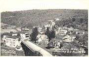
Gormania, viewed from US 50 bridge, 1940s
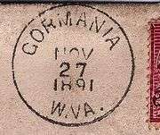
Gormania postmark
References
- ↑ U.S. Geological Survey Geographic Names Information System: Gormania, West Virginia
- ↑ Kenny, Hamill (1945). West Virginia Place Names: Their Origin and Meaning, Including the Nomenclature of the Streams and Mountains. Piedmont, WV: The Place Name Press. p. 277.
Municipalities and communities of Grant County, West Virginia, United States | ||
|---|---|---|
| City | 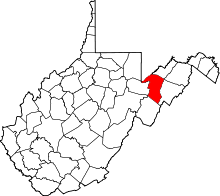 | |
| Town | ||
| Unincorporated communities | ||
| Footnotes | ‡This populated place also has portions in an adjacent county or counties | |
This article is issued from
Wikipedia.
The text is licensed under Creative Commons - Attribution - Sharealike.
Additional terms may apply for the media files.