Eastern Continental Divide
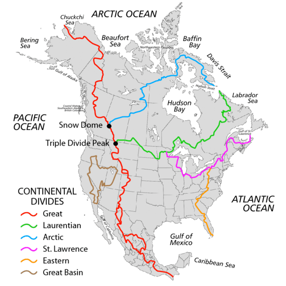
The Eastern Continental Divide (ECD) or Appalachian Divide or Eastern Divide, in conjunction with other continental divides of North America, demarcates two watersheds of the Atlantic Ocean: the Gulf of Mexico watershed and the Atlantic Seaboard watershed. As can be readily seen from the first map at the right, the Gulf watershed demarcated by the Great Divide in red begins along the spine of the mountains of Central America and runs through the American Rockies where is terminates in the triple divide at Triple Divide Peak in Glacier National Park along the U.S.-Canadian border where the Laurentian Divide blocks the waters from traveling south to the Gulf of Mexico.
Prior to about 1760, north of Spanish Florida, the Appalachian Divide, according to the French Crown, represented the boundary between British and French colonial possessions in North America.[lower-alpha 1] The English contested the claims and the border throughout much of the 1600s as they absorbed the Dutch and Swede settlers and grew in population as the Amerindians died off from epidemic disease and internecine warfare[1] over the Beaver fur trade.[2] Overall, the Eastern Continental Divide runs south-southwest from the Eastern Triple Divide[lower-alpha 2] from the summit named 'Triple Divide peak'[3] 10.40 mi (16.73 km) due south of the New York-Pennsylvania line.[4] The summit named 'Triple Divide peak' is the northernmost peak of three atop a broad plateau which is currently farmland[5] near the junction of Kidney and Rooks Roads in Ulysses Township, near the Allegany Township line in Potter County Pennsylvania.[6] From that northernmost peak and staying on alternative sides of Rooks Road, the ECD runs through the two nearby southern summits then southerly along the Allegheny Plateau staying west of the Allegheny Front until it plunges south along the Appalachians between the Eastern Seaboard States, and the states across or astride the Appalachians barrier ridge. As the altitude of the peaks diminishes across the Georgia, often swampy, plateau the divide meanders into the low country of Northern Florida until it reaches central Florida, ending above the north bank watershed of the Kissimmee River, which drains via Lake Okeechobee and the Okeechobee Canal Okeechobee Waterway to both the Gulf of Mexico and the Atlantic Ocean. Similarly, the summit of the Triple Divide drains three ways, but only because two rivers official sources are within two miles: The St. Lawrence destined Genesee River and the Allegheny River Mississippi tributary both have source springs less than two miles from the junctions of Pennsylvania Route 49 and PA 449 a bit down the Genesee watershed from the Triple Divide summit.
The geography for the Royal Proclamation of 1763 formulated by the Crown hoped to fully separate the populations of the Thirteen Colonies from the Native American Tribal lands north and west of it, so the proclamation border generally runs along, or close to, the Eastern Continental Divide's line going from the southern Georgia border northwards to the existing Pennsylvania/New York state border, and from there northeastwards along the St. Lawrence Divide into New England. That is, the divide is abandoned by the proclamation language to jog around the lands of where the Iroquois were a military power for 200 years, geographically the right bank (south side) of the St. Lawrence valley eastwards into northeastern colonial Massachusetts (Maine).[lower-alpha 3] It is no mistake these were the very lands claimed and controlled by the Six Nations of the Iroquois, New France's most dogmatic foe,[lower-alpha 4] and England's most powerful military force on the continent during the French and Indian War.[lower-alpha 5]
Because the divide represents the highest terrain, air is forced upwards regardless of wind direction. This process of orographic enhancement leads to higher precipitation than surrounding areas. In winter, the divide is often much snowier than surrounding areas, due to orographic enhancement and cooler temperatures with elevation. Some locations in North Carolina average up to 100 inches (2,500 mm) of snow a year, and up to 175 inches (4,400 mm) a year falls in parts of West Virginia.
 Red Creek west of the crest of the Allegheny Front in the Dolly Sods area of West Virginia; the creek originates along the Eastern Continental Divide, with its waters flowing to the Gulf of Mexico as part of the Ohio River watershed. |
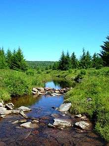
 Seneca Creek, incised into the Allegheny Front west of Seneca Rocks, West Virginia. This short but steep creek originates along the Eastern Continental Divide; its waters flow into the Atlantic Ocean via the Potomac River and Chesapeake Bay. |
Locations
Notes
- ↑ Under the management of Cardinal Richelieu France created New France and got a jump on exploring North America and staking territorial claims, relative to the squabbling Dutch and British and Swedish Empire of Gustavus Adolphus the Great, so claimed the drainage areas of the Mississippi River and the Saint Lawrence River before Dutch, Swedes, or English settlers had colonized the continent. Spain contested these French claims in the south with a good claim based on explorers in the 16th century, while in the north the Swedes, Dutch, and British had all laid 'extension claims' that extended west to the Pacific Ocean along a parallel of longitude. These passed to the English with the end of New Amsterdam and New Sweden at the end of the fourth Anglo-Dutch war.
The French claims were validated by the international treaties ending the French and Indian War (1756-1763), and the American Revolution (1781), which lead to the new U.S. Congress creating the Northwest Territory soon after beginning business as a government — thus legalizing settlements in the midwest and regularizing the region as a U.S. Territory. The validated claim also set up the Emperor Napoleon Bonaparte's later sale of the whole drainage basin of the Mississippi-Missouri Rivers to Thomas Jefferson as the Louisiana Purchase in 1803.
Subsequently, President Jefferson sent the Lewis and Clark Expedition to report on the Louisiana country and to the Oregon Country, which was technically the United States by default because of those optimistic claims along a parallel to the Pacific Ocean—the colonial charters claim having been assigned to the new constitutional United States federal government during the same legislative frenzy when conflicting claims by the 13 member states were settled and the war debts passed to the new federal government.
At the time, the northern border with Canada had yet to be set, a matter tabled as it merely passed through the Amerindian lands unoccupied as yet by white settlers west of the Great Lakes; so the expedition also bolstered the United States claims on Northern California, Oregon, and Washington. - ↑ The Triple Divide summit is at an elevation of 2,507 feet (764 m), or 764 m per GNIS data.[3]
- ↑ The language of the Royal proclamation was sufficiently broad that the effect was to force eviction of settlers on the western or northern side of the divides, evictions carried out by the Crown's Red Coated soldiers — often without consideration of property or difficulty in transporting chattels, consequently, many pioneer families were often made to uproot themselves without time to prepare at all or were given scant time to gather themselves, for the long walk along the muddy roads back to the east — creating great resentments as years work were necessarily abandoned, the whole matter as the proclamation was inforced over the next decade creating a serious casus belli causing many outside the great ports to support independence.
- ↑ The Iroquois vs. French was normally one of hostility from the day in 1608 when Champlain had killed three war sachems along Lake Champlain when accompanying a mixed Huron and Algonquian war party on a raid of the Iroquois.
- ↑ Fortunately, while much of lower New York and excepting Kentucky, northern lands of the Iroquois north of the Ohio River had been purged of settlers before the revolution, and the Iroquois tribes were divided on which side to support (even within several of their nations) in the Revolution, war bands of Indians, sometimes joined by Tories (Loyalists) banded together and raided the frontier and older established towns during the conflict, especially during 1777 and 1778, which raids resulted in several massacres.[7] The Continental Congress directed General Washington to send a military force to chastise those Iroquois and Tories making war on the Pennsylvania, Connecticut, and New York frontiers, which he dispatched as the Sullivan Expedition — which burned so many Iroquois towns they've named Washington the Town Burner, ever since.
References
- ↑
Alvin M. Josephy, Jr., ed. (1961). The American Heritage Book of Indians. The editors of American Heritage Magazine. American Heritage Publishing Co., Inc. LCCN 61-14871.
Some, maybe many, escaped from the long nightmare to the intact tribes beyond the [colonies'] borders; the Narraganset went to Maine and turn [into] Abnaki by the hundreds, maybe thousands, after King Philip's War; and the parade of Tuscarora plodding north to the Iroquois took 100 years to pass.
, pages 180-211, 188-189
But one after the other of the intact tribes marched to destruction in their turn in the major colonial wars from 1689 to 1763, echoes for the most part of European wars between France and England, but in America, fought on the American plan, with as much use as possible of Indian allies. - ↑ Alvin M. Josephy, Jr., ed. (1961). The American Heritage Book of Indians. The editors of American Heritage Magazine. American Heritage Publishing Co., Inc. LCCN 61-14871.
- 1 2 "Triple Divide". Geographic Names Information System. United States Geological Survey.
- ↑ Satellite data/software measured on www.google.com/maps, then painstakingly checked & re-measured as 10.37 mi (16.69 km) from intersection to 'saddle (landform) athwart the New York-Pennsylvania line just right (east) of the summit at co-ords 41.997419,-77.838037 in northern Genesee Township during which carefully verified the ruler tool was as north-south as possible (netting 0.03 mi).
- ↑ By Google earth, 2017-03-09
- ↑ Map features as located by both this search url in maps.google.com and Google earth using the decimal Latitude and Longitude co-ordinates.
- ↑ J. Simpson Africa (1883). LOUIS H. EVERTS, ed. "HISTORY OF HUNTINGDON AND BLAIR COUNTIES, PENNSYLVANIA". Philadelphia: The Tory Expedition to Kittanning, J.B. Lippincott & Co. pp. Page 26.
...a sufficient force to garrison the frontier defenses, a large body of scouts was sent out to traverse the country along the eastern base of the Allegeheny (sic) Mountain, watch the gaps, and note the approach of the expected invaders.
- ↑ "Elevation Chart". The Great Allegheny Passage: The Cumberland and Pittsburgh Trail. Allegheny Trail Alliance. Archived from the original on May 6, 2009. Retrieved 2009-11-09. Maps: Eastern Continental Divide Archived 2010-05-15 at the Wayback Machine.