Casselman Bridge
| Casselman River Bridge State Park | |
| Maryland State Park | |
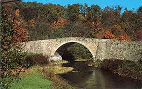 The bridge's south aspect | |
| Country | United States |
|---|---|
| State | Maryland |
| County | Garrett |
| Elevation | 2,113 ft (644 m) [1] |
| Coordinates | 39°41′48″N 79°08′37″W / 39.69667°N 79.14361°WCoordinates: 39°41′48″N 79°08′37″W / 39.69667°N 79.14361°W [1] |
| Area | 4 acres (2 ha) [2] |
| Established | 1957 |
| Management | Maryland Department of Natural Resources |
| Nearest city | Grantsville, Maryland |
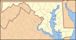 Location in Maryland | |
| Website: Casselman River Bridge State Park | |
|
Casselman's Bridge, National Road | |
 | |
| Location | East of Grantsville on U.S. Route 40 Alternate, Grantsville, Maryland |
| Area | < 1 acre |
| Built | 1813-1814 |
| Architect | Unknown |
| Architectural style | Other |
| NRHP reference # | 66000391 |
| Significant dates | |
| Added to NRHP | October 15, 1966 |
| Designated NHL | January 29, 1964 |
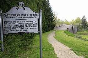
The Casselman Bridge is an historic transportation structure located 0.5 miles (0.80 km) east of Grantsville in Garrett County, Maryland.[3] The bridge was built to carry the National Road across the Casselman River. Historic markers posted at each end read:
Erected 1813 by David Shriver, Jr.,
Sup't of the "Cumberland Road" (The
National Road). This 80 foot span
was the largest stone arch in America
at the time. It was continuously
used from 1813 to 1933.[4]
Since 1957, the structure, which has also been known as Casselmans Bridge, Castleman's Bridge, and Little Crossings Bridge, has been preserved by the state of Maryland as Casselman River Bridge State Park.[5] The bridge was declared a National Historic Landmark in 1964,[6] and placed on the National Historic Register in 1966.[7]
History
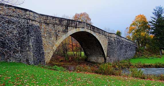
The 354-foot-long (108 m) stone arch bridge spans 48 feet (15 m) with a 30-foot-high (9.1 m) arch.[8] The bridge was constructed in 1813-1814 to aid in the westward movement through the frontier wilderness west of Cumberland, Maryland. The first wheeled vehicles crossed the bridge in 1815.[9] As a "tidal wave" of western expansion followed the opening of the National Road, Casselman Bridge had heavy traffic that included wagons drawn by 12-horse teams and carrying 10-ton loads.[7] A small portion of the original National Road still exists at the approaches to the bridge.[8]
The bridge was strengthened for motorized traffic in 1911 and continued in service as a highway until 1933, when a modern steel span was built nearby to serve what is now US Route 40 Alternate.[9] In the 1940s and early 1950s, efforts were made to preserve the bridge when sections started to crumble and fall apart. The bridge was closed to vehicles in 1953[10] and partially restored by the state in the mid-1950s.[11] Additional maintenance occurred in 1979, 1996, 2002, and 2012.[12]
Activities and amenities
The state park offers picnicking facilities and fishing opportunities in Casselman River. The bridge is open to foot traffic. Stanton's Mill, which is also on National Register of Historic Places, lies adjacent to the park.[3] The Spruce Forest Artisan Village can be found directly off of the east end of the bridge. Penn Alps Restaurant and The Cornucopia Cafe can be easily accessed through the village.
 Bridge in 2014
See also
References
- 1 2 "Casselman Bridge". Geographic Names Information System. United States Geological Survey.
- ↑ "Fiscal Year 2016 DNR Owned Lands Acreage" (PDF). Maryland Department of Natural Resources. July 29, 2016. Retrieved November 2, 2017.
- 1 2 "Casselman River Bridge State Park". Maryland Department of Natural Resources. Retrieved January 10, 2014.
- ↑ "Castleman's River Bridge". Historical Marker Database. Retrieved January 10, 2014.
- ↑ "DNR restricts access to the bridge and the immediate area" (Press release). Maryland Department of Natural Resources. March 6, 2012. Archived from the original on January 4, 2013. Retrieved July 30, 2015.
- ↑ "Listing by State: Maryland" (PDF). National Historic Landmarks Program. National Park Service. Retrieved July 30, 2015.
- 1 2 Joseph Scott Mendinghall, Historian (May 3, 1976). "Casselman Bridge, National Road". National Register of Historic Places Inventory Nomination. National Park Service. Retrieved May 27, 2016.
- 1 2 "Casselman Bridge, National Road". National Register Listings in Maryland. Maryland Historic Trust. Retrieved January 10, 2014.
- 1 2 "Little Crossings Bridge, National Road". Library of Congress. Retrieved July 30, 2015.
- ↑ "Repairs scheduled for Casselman River Bridge". Maryland Department of Natural Resources. September 28, 2012. Archived from the original on July 4, 2013. Retrieved July 30, 2015.
- ↑ "Casselman River Bridge State Park History". Maryland Department of Natural Resources. Retrieved July 30, 2015.
- ↑ Sawyers, Michael A. (June 25, 2012). "No stone left unturned on Casselman Bridge". Cumberland Times-News. Cumberland, Md. Retrieved July 30, 2015.
External links
| Wikimedia Commons has media related to Casselman Bridge. |
- Casselman River Bridge State Park Maryland Department of Natural Resources
- Inventory No. G-II-C-014: Casselman Bridge, National Road (various documents) Maryland State Archives
- Historic American Buildings Survey (HABS) No. MD-139, "Casselman River Bridge", 3 photos
- Historic American Engineering Record (HAER) No. MD-128, "Little Crossings Bridge", 2 measured drawings
- Casselman Bridge, Garrett County, including photo from 1996, at Maryland Historical Trust
| Topics |   | |
|---|---|---|
| Lists by county | ||
| Lists by city | ||
| Other lists | ||
| ||