Patapsco River
| Patapsco River (Potapskut) | |
| River of History | |
 | |
| Country | United States |
|---|---|
| State | Maryland |
| Region | Baltimore metropolitan area, Patapsco Valley |
| Tributaries | |
| - left | North Branch |
| - right | South Branch |
| Cities | Baltimore, Elkridge, Ellicott City |
| Source | |
| - location | Marriottsville |
| - elevation | 260 ft (79 m) |
| - coordinates | 39°20′59″N 76°52′56″W / 39.3498272°N 76.8821987°W |
| Mouth | Chesapeake Bay |
| - location | Baltimore |
| - elevation | 0 ft (0 m) |
| - coordinates | 39°10′25″N 76°26′36″W / 39.1737202°N 76.4432935°WCoordinates: 39°10′25″N 76°26′36″W / 39.1737202°N 76.4432935°W |
| Basin | 632 sq mi (1,637 km2) |
.png) Patapsco River Watershed | |

The Patapsco River mainstem is a 39-mile-long (63 km)[1] river in central Maryland which flows into the Chesapeake Bay. The river's tidal portion forms the harbor for the city of Baltimore. With its South Branch, the Patapsco forms the northern border of Howard County, Maryland. The name "Patapsco" is derived from the Algonquian pota-psk-ut, which translates to "backwater" or "tide covered with froth."[2]
History
Captain John Smith was the first European to explore the river noting it on his 1612 map as the Bolus River. The "Red river", was named after the clay color, and is considered the "old Bolus", as other branches were also labelled Bolus on maps.[3] As the river was not navigable beyond Elkridge, it was not a major path of commerce with only one ship listed as serving the northern branch, and four others operating around the mouth in 1723.[4]
The Patapsco River is referred to as The River of History as it is regarded as the center of Maryland’s Industrial Revolution beginning in the 1770s.[5] Milling and manufacturing operations abounded along the river throughout the eighteenth and nineteenth centuries, generally relying on water power generated by multiple small dams. The nation’s first railroad, the Baltimore and Ohio Railroad's original main line west constructed from 1829 onwards along the Patapsco valley, and this route remains, though much altered. Many old railroad bridges were constructed in the valley, most notably the Thomas Viaduct and the Patterson Viaduct, of which ruins remain. Flour mills and, in 1907, the hydropower dam were formerly powered by the river.
The valley is prone to periodic flooding. Modern floods include the 1868 flood that washed away 14 houses and killed 39 people around Ellicott City. A 1923 flood topped bridges while in 1952, an eight-foot wall of water swept the shops of Ellicott City. A 1956 flood inflicted heavy damage at the Bartigis Brothers plant.[6] In 1972, as a result of rainfall from the remnants of Hurricane Agnes, Ellicott City and the Old Main Line sustained serious damage. The July 2016 Maryland flood ravaged Main Street leaving two dead, followed just two years later by a flash flood on May 27, 2018 that took the life of one rescuer.[7]
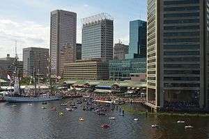
The mouth of the Patapsco River forms Baltimore harbor, the site of the Battle of Baltimore during the War of 1812. This is where Francis Scott Key, while aboard a British ship, wrote "The Star-Spangled Banner," a poem later set to music as the national anthem of the United States. Today, a red, white, and blue buoy marks the spot where HMS Tonnant was anchored.
Geography
Watershed
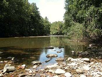
The Patapsco has a watershed area (including the water surface) of 950 square miles (2,460 km2).[8] Through most of its length, the Patapsco is a minor river, flowing for the most part through a narrow valley. The last 10 miles (16 km), however, form a large tidal estuary inlet of Chesapeake Bay. The inner part of this estuary provides the harbor of Baltimore, composed of the Northwest Harbor and the Middle Branch including Thoms Cove. (See Baltimore Inner Harbor.) The Patapsco estuary is south of the Back River and north of the Magothy River. The Patapsco River forms the harbor as it empties into the Chesapeake Bay. Besides Baltimore, the river also flows through Ellicott City (the county seat of Howard County) and Elkridge.
The Patapsco River mainstem begins at the confluence of the North and South Branches, near Marriottsville, approximately 15 miles (24 km) west of downtown Baltimore. The 19.4-mile-long (31.2 km)[1] South Branch rises further west at Parr's Spring, where Howard County, Carroll, Frederick, and Montgomery counties meet. The latter begins at elevation 780 feet (240 m) on Parr's Ridge, just south of Interstate 70 and east of Ridge Road (Highway 27), two miles south of Mount Airy, Maryland.[1] The South Branch Patapsco River traces the southern boundary of Carroll County and the northern boundary of Howard County. The first land record regarding Parr's Springs dates from 1744, when John Parr laid out a 200 acres (81 ha) tract he called Parr's Range. During the Civil War, Parr's Spring was a stop for the Army of the Potomac's Brig. Gen. David M. Gregg's cavalry, on June 29, 1863, while en route to Gettysburg, Pennsylvania.[9] Parr's Spring was dug to form a 1.75 acres (0.71 ha) pond in the 1950's, filled by seven spring heads that form the headwaters of the South Branch of the Patapsco River.[10]
The North Branch flows 20.9 miles (33.6 km)[1] southward from its origins in Carroll County. Liberty Dam and its reservoir, located on the North Branch, is a major component of the Baltimore city water system.[11]
Patapsco Valley State Park extends along 32 miles (51 km) of the Patapsco and its branches, encompassing a total of 14,000 acres (5,700 ha) in five different areas. The river cuts a gorge 100–200 feet (35–70 m) deep within the park, which features rocky cliffs and tributary waterfalls. Bloede's Dam,a hydroelectric dam built in 1906, was located on the Patapsco River within the Park. It was a nearly complete barrier to anadromous fish passage. Although a fish ladder was installed in 1992, it blocked five of six native fish species trying to run upstream to spawn.[12] Impetus to remove Bloede's Dam began in the 1980s when nine drowning deaths occurred, and also to restore fish passage to a large portion of the Patapsco River watershed.[13][14] Dam demolition began on September 12, 2018, opening the fishery and creating a rocky rapid for kayaking.[15] Two dams upstream of Bloede's Dam, Simkins and Union, were removed in 2010.[16][8] The removal of Bloede's Dam leaves Daniels Dam, 9 miles (14 km) upstream, as the last remaining dam along the mainstem Patapsco River.[12]
Tributaries
- Deep Run (Carroll County)
- Board Run (Baltimore County)
- Roaring Run (Carroll County)
- Liberty Reservoir (Carroll/Baltimore Counties)
- Keysers Run (Baltimore County)
- Beaver Run (Carroll County)
- Norris Run (Baltimore County)
- Timber Run (Baltimore County)
- Middle Run (Carroll County)
- Morgan Run (Carroll County)
- Locust Run (Baltimore County)
- Snowdens Run (Carroll County)
- Falls Run (Baltimore County)
- South Branch Patapsco River
- Davis Branch (Howard County)
- Brice Run (Baltimore County)
- Bens Run (Baltimore County)
- Cedar Branch (Baltimore County)
- Miller Run (Baltimore County)
- Sucker Branch (Howard County)
- Tiber River (Howard County)
- Cooper Branch (Baltimore County)
- Bonnie Branch (Howard County)
- Sawmill Branch (Baltimore County)
- Cascade Falls (Howard County)
- Soapstone Branch (Baltimore County)
- Rockburn Branch (Howard County)
- Deep Run (Howard/Anne Arundel County)
- Stony Run (Anne Arundel County)
- Herbert Run (Baltimore County)
- Holly Creek (Anne Arundel County)
- Middle Branch to Gwynns Falls (Baltimore City)
- Northwest Harbor to Jones Falls (Baltimore City)
- Colgate Creek (Baltimore City)
- Curtis Creek (Baltimore City)
- Bear Creek (Baltimore County)
- Cox Creek (Anne Arundel County)
- Stoney Creek (Anne Arundel County)
- Rock Creek (Anne Arundel County)
- Old Road Bay (Baltimore County)
- Bodkin Creek (Anne Arundel County)
Ecology and Conservation
Removal of Bloede's Dam in September, 2018 opened up 65 miles (105 km) of the Patapsco River watershed which will potentially restore spawning runs of at least six species of native anadromous fish: alewife (Alosa pseudoharengus), blueback herring (Alosa aestivalis), American shad (Alosa sapidissima), hickory shad (Alosa mediocris), striped bass (Morone saxatilis), sea lamprey (Petromyzon marinus), as only one species, sea lamprey, were found using the Bloede's Dam fish ladder in 2012.[12] One catadromous species would likely also benefit, the American eel (Anguilla rostrata), a fish species which lives in freshwater and migrates to the ocean to breed. The Bloede's Dam removal project was led by American Rivers and the Maryland Department of Natural Resources.[12]
Now that Bloede's Dam has been removed, removal of Daniels Dam upstream on the mainstem Patapsco River would open to anadromous fishes the remaining 6.5 miles (10.5 km) of Patapsco River mainstem, the entire 19.4 miles (31.2 km) length of the South Branch Patapsco River, 3.5 miles (5.6 km) of the North Branch Patapsco River up to the Liberty Dam, and many of these rivers' tributaries.[1]
Water quality
The eastern portion of the Patapsco River is in a highly urbanized area and is subject to extensive stormwater runoff and other forms of water pollution. The Maryland Department of the Environment has identified the Lower North Branch as containing high levels of heavy metals (chromium, arsenic, cadmium, copper, mercury, nickel, lead, selenium, and zinc), as well as phosphorus, fecal coliform bacteria, and PCBs.[17]
Clean-up efforts by the residents of surrounding communities have been led by environmental nonprofit organizations, such as The Friends of Patapsco Valley & Heritage Greenway, Inc. (PHG). From 2006 to 2012, PHG volunteers participated in 183 stream clean ups, removing 264 tons of trash from the streams of the Patapsco Valley watershed.[18]
Recreation
Teenagers enjoy swimming in areas of the Patapsco River, typically including rope swings, inner tubing, and wading. The river also serves as a venue for rafting.
Bridges
| Crossing | Carries | Location |
|---|---|---|
| Howard County - Baltimore County | ||
| MD 125 bridge | Woodstock | |
| Eureka bridge | B&O Old Main Line Subdivision | Mt. Airy |
| Daniels bridge | B&O Old Main Line Subdivision | Daniels |
| Hollifield Bridge | Old Frederick Road | Daniels |
| I-70 bridge | Ellicott City Catonsville | |
| Baltimore National Pike Bridge | Ellicott City Catonsville | |
| Main Street Bridge | Ellicott City Oella | |
| Ilchester Road bridge | Ilchester Road | Ilchester |
| Ilchester Bridge | B&O Old Main Line Subdivision | Ilchester |
| Grist Mill Trail Bridge | Grist Mill Trail | Ilchester |
| Patapsco Swinging Bridge | Patapsco Swinging Bridge Trail | Ilchester |
| Gun Road bridge | Gun Road | Relay |
| I-95 bridge | Elkridge Relay | |
| Thomas Viaduct | B&O Capital Subdivision | Elkridge Relay |
| US 1 bridge | Elkridge Relay | |
| I-895 bridge | Elkridge Relay | |
| Anne Arundel County – Baltimore County | ||
| I-195 bridge | Elkridge Halethorpe | |
| Northeast Corridor bridge | Amtrak Northeast Corridor | Linthicum Halethorpe |
| Baltimore Beltway bridge | Linthicum Lansdowne | |
| Hammonds Ferry Road bridge | Hammonds Ferry Road | Linthicum Lansdowne |
| BW Parkway bridge | Baltimore Highlands | |
| MD 648 bridge | Baltimore Highlands | |
| Central Light Rail bridge | Baltimore Light Rail | Baltimore Highlands |
| I-895 bridge near South West Area Park | Baltimore Highlands | |
| Patapsco Avenue bridge | Patapsco Avenue | Brooklyn, Baltimore |
| Curtis Bay Branch Railroad bridge | B&O Curtis Bay Branch | Baltimore |
| Hanover & Potee Streets bridge | Baltimore | |
| Fort McHenry Tunnel | Baltimore | |
| Baltimore Harbor Tunnel | Baltimore | |
| Francis Scott Key Bridge | Baltimore | |
See also
References
- 1 2 3 4 5 U.S. Geological Survey. National Hydrography Dataset high-resolution flowline data. The National Map Archived 2012-04-05 at WebCite, accessed April 1, 2011
- ↑ "Ghosts of industrial heyday still haunt Baltimore's harbor, creeks". Chesapeake Bay Journal. Retrieved 2012-09-08.
- ↑ John Thomas Scharf. The Chronicles of Baltimore: Being a Complete History of Baltimore Town. p. 8.
- ↑ John Thomas Scharf. The Chronicles of Baltimore: Being a Complete History of Baltimore Town. p. 18.
- ↑ Paul J. Travers (2016). The Patapsco: Baltimore's River of History. Schiffer Publishing Limited. p. 220. ISBN 9780870336447. Retrieved September 14, 2018.
- ↑ "The Patapsco River Creator-Destroyer". The Times (Ellicott City). 31 March 1965.
- ↑ https://www.11alive.com/amp/article?section=weather&headline=devastating-dangerous-ellicott-citys-main-street-hit-with-flooding-again&contentId=65-558994116
- 1 2 Yantao Cui, Mathias J. Collins, Mary Andrews, Graham C. Boardman, John K. Wooster, Marty Melchior, Serena McClain. "Comparing 1-D sediment transport modeling with field observations: Simkins Dam removal case study". International Journal of River Basin Management: 1–13. doi:10.1080/15715124.2018.1508024. Retrieved September 4, 2018.
- ↑ Frederic Shriver Klein (2000). Just South of Gettysburg: Carroll County, Maryland in the Civil War : Personal Accounts and Descriptions of a Maryland Border County. Historical Society of Carroll County. p. 247.
- ↑ Sheridan Lyons (May 15, 2000). "Beneath the pier, 4 counties meet". The Baltimore Sun. Retrieved September 16, 2018.
- ↑ Baltimore County Department of Environmental Protection and Resource Management. Towson, MD. "Patapsco River Watershed." 2009-07-13.
- 1 2 3 4 William Harbold, Scott Stranko, Jay Kilian, Matt Ashton, Patrick Graves (May 1, 2013). Patapsco River Dam Removal Study: Assessing Changes in American Eel Distribution and Aquatic Communities - Final Report (PDF) (Report). Maryland Department of Natural Resources. Retrieved September 4, 2018.
- ↑ Rachael Pacella (23 March 2016). "Bids set to go out for removal of Bloede Dam at Patapsco Valley State Park". The Baltimore Sun.
- ↑ "Man, 18, drowns near dam". The Baltimore Sun. May 22, 1982. p. C2.
- ↑ http://dnr.maryland.gov/fisheries/pages/fishpassage/bloede.aspx
- ↑ Scott Dance (September 5, 2018). "After a century on the Patapsco River, Bloede Dam's removal set to begin with a blast". The Baltimore Sun. Retrieved September 5, 2018.
- ↑ Maryland Department of the Environment. Baltimore, MD (2009). "Notice of Intent to Establish Total Maximum Daily Load (TMDL) of Sediment: Patapsco River Lower North Branch Watershed."
- ↑ "Protecting the Valley". Friends of Patapsco Valley & Heritage Greenway, Inc. Retrieved May 24, 2012.
External links
| Wikimedia Commons has media related to Patapsco Valley State Park. |
- Maryland DNR's Surf Your Watershed: Patapsco/Back River
- American Rivers, a nonprofit conservation organization
- Maryland Port Administration
- Blue Water Baltimore, formed in 2010 from a merger of the Gwynns Falls, Jones Falls, Herring Run, and Baltimore Harbor Watershed associations, and the Baltimore Harbor Waterkeeper
- Patapsco Heritage Greenway
- Patapsco River Rock Building