Greenbelt, Maryland
| Greenbelt, Maryland | |||
|---|---|---|---|
| City | |||
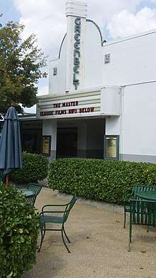
.jpg) Roosevelt Center in March 2011. The city's commercial center typifies the Art Deco style used during the original construction of Greenbelt. | |||
| |||
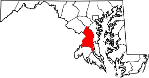
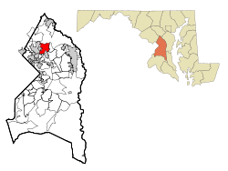 Location in Prince George's County and Maryland | |||
 Greenbelt Location within the state of Maryland  Greenbelt Greenbelt (the US) | |||
| Coordinates: 38°59′41″N 76°53′07″W / 38.9946701°N 76.8853989°WCoordinates: 38°59′41″N 76°53′07″W / 38.9946701°N 76.8853989°W[1][2] | |||
| Country |
| ||
| State |
| ||
| County |
| ||
| Incorporated | 1937-06-01[3] | ||
| Government | |||
| • Mayor | Emmett V. Jordan (D) | ||
| Area[1][2] | |||
| • Total | 6.23 sq mi (16.15 km2) | ||
| • Land | 6.18 sq mi (16.00 km2) | ||
| • Water | 0.06 sq mi (0.14 km2) 0.99% | ||
| Elevation | 157 ft (48 m) | ||
| Population (2010)[4] | |||
| • Total | 23,068 | ||
| • Estimate (2017)[5] | 23,489 | ||
| • Density | 3,700/sq mi (1,400/km2) | ||
| Time zone | UTC−5 (Eastern) | ||
| • Summer (DST) | UTC−4 (Eastern) | ||
| ZIP codes | 20770, 20771, 20768 | ||
| Area code(s) | 301 and 240 | ||
| FIPS code | 24-34775 | ||
| GNIS feature ID | 0597493 | ||
| Website |
www | ||

Greenbelt is a city in Prince George's County, Maryland, United States, and a suburb of Washington, D.C..[1][2] Greenbelt is notable for being the first and the largest of the three experimental and controversial New Deal Greenbelt Towns, planned and built by the Federal government of the United States.[6] The cooperative community was conceived in 1935, by Undersecretary of Agriculture Rexford Guy Tugwell,[7][6] who was perceived by some of his contemporaries as having held a collectivist ideology and this was utilized as a source of opposition to the Greenbelt Towns project throughout its short duration.[6] The project came into legal existence in the spring of 1935. On April 8, 1935, the United States Congress passed the Emergency Relief Appropriation Act of 1935.[8][7] Under the authority granted to him from this legislation, President Franklin D. Roosevelt issued an executive order, on May 1, 1935, establishing the United States Resettlement Administration (RA / RRA).[7]
Originally referred to as Maryland Special Project No. 1, the project was officially given the name Greenbelt when the Division of Suburban Resettlement of the Resettlement Administration began construction on January 13, 1936, approximately 8 miles north of Washington, D.C.[6] The complete Greenbelt plans were reviewed at the White House by President Roosevelt and First Lady Eleanor Roosevelt on April 30, 1936. [6]The first tenants, after being selected through a stringent and restrictive application process, moved into the town, which consisted of structures built in the Art Deco, Streamline Moderne, and Bauhaus architectural styles, on September 30, 1937.[6]
Greenbelt is credited as a historic milestone in urban development, which includes its role as having served as the initial model for the privately constructed suburban Washington, D.C. planned cities of Reston, Virginia and Columbia, Maryland.[6]
Known locally as Old Greenbelt, the original, federally-built core of the city was recognized as the Greenbelt Historic District by the Maryland Historical Trust, and is listed on the National Register of Historic Places as a National Historic Landmark District.
Greenbelt's population, which includes residents of private sector dwellings that were constructed over several decades subsequent to the federal government's ownership of the city, was recorded as 23,068 in the 2010 U.S. Census.
Geography

Greenbelt is located at 38°59′41″N 76°53′07″W / 38.99467°N 76.885399°W[1][2]. According to United States Census Bureau data, as of January 1, 2018, the city has a total area of 6.23 square miles (16,146,235 square meters), of which, 6.18 square miles (16,003,389 square meters) is land, and 0.06 square miles (142,846 square meters) is water.[1][2] Greenbelt's ZIP Codes are 20770, 20771, and 20768. The ZIP Code 20770 contains all residential and business addresses that correspond to actual physical locations inside the geographic boundaries of the City of Greenbelt. The 20771 ZIP Code is assigned exclusively to post-office box (P.O. Box) addresses, while 20768 is the designated ZIP Code for Goddard Space Flight Center, situated on federal government owned land that is contiguous with a portion of Greenbelt's eastern border.[9][10]
NASA's Goddard Space Flight Center, located directly adjacent to Greenbelt's eastern boundary, utilizes a Greenbelt postal address (Greenbelt, MD 20768), as well. It is partially within the former Goddard census-designated place.[11][12]
Greenbelt Park, a unit of the National Park System, is located within the City of Greenbelt's boundaries, at its southernmost portion.
Transportation
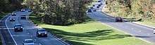
Two major highways pass through and have interchanges in Greenbelt: the Capital Beltway (I-95/I-495) and the National Park Service's owned and maintained portion of the Baltimore–Washington Parkway (unsigned MD 295). The Greenbelt portion of the Baltimore–Washington Parkway (B–W Parkway) is part of the parkway's 19-mile section which was listed on the National Register of Historic Places in 1991.[13]
Additionally, Greenbelt Road is part of state highway MD 193, which connects several suburban communities in both Prince George's and Montgomery counties. Kenilworth Avenue (MD 201) traverses Greenbelt in a north-south direction, running parallel to the B–W Parkway, providing an alternate travel route into Washington, D.C., from Greenbelt. The southernmost Maryland portion of Kenilworth Avenue forms a major interchange with both the B–W Parkway and US 50 near the Maryland–D.C. line, and continues into Washington, as the Kenilworth Avenue Freeway (DC 295).
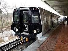
Washington Metro's rapid transit rail system serves Washington, D.C., and neighboring communities in Maryland and Northern Virginia, by operating 91 Metro stations, which includes the Greenbelt station, the northern terminus of Metro's Green Line. Commuter rail service to the station is provided by MARC Train's Camden Line, which connects the District of Columbia's Washington Union Station with Camden Station in Baltimore. The Camden Line provides service by utilizing the original 1835 Baltimore and Ohio Railroad (B&O) track route between Washington and Baltimore, now part of the CSX System.
Bordering areas
- Beltsville Agricultural Research Center
- Berwyn Heights
- College Park
- Goddard
- Lanham
- New Carrollton
- Glenn Dale
History
Greenbelt was settled on September 30, 1937, as a public cooperative community in the New Deal era.[6] The concept was at the same time both eminently practical and idealistically utopian: the federal government would foster an "ideal" self-sufficient cooperative community that would also ease the pressing housing shortage near the nation's capital. Construction of the new town would also create jobs and thus help stimulate the national economic recovery following the Great Depression.
Greenbelt, which provided affordable housing for federal government workers, was one of three Greenbelt Towns conceived in 1935, by President Franklin D. Roosevelt's Brain Trust member Rexford Tugwell, who was serving as the president's Undersecretary of Agriculture. The project was officially authorized in May 1935. First, on April 8, 1935, the United States Congress passed the Emergency Relief Appropriation Act of 1935. Then under the authority granted to him from this legislation, President Roosevelt issued an executive order, on May 1, 1935, establishing the United States Resettlement Administration (RA / RRA).[8][7] Rexford Tugwell agreed to serve as the Administrator of the Resettlement Administration, in addition to his Undersecretary of Agriculture position, without receiving any additional salary.[7]
Working alongside Tugwell was Charles W. Yost. The two other Greenbelt Towns are Greendale, Wisconsin (near Milwaukee) and Greenhills, Ohio (near Cincinnati). A fourth town, Roosevelt, New Jersey (originally called Homestead), was planned but was not fully developed on the same large scale as Greenbelt.[14][15]
Eleanor Roosevelt, wife of President Franklin D. Roosevelt, helped Tugwell lay out the Maryland town on a site that had formerly consisted largely of tobacco fields. She was also heavily involved in the first cooperative community designed by the federal government in the New Deal Era, Arthurdale, West Virginia, which sought to improve the lives of impoverished laborers by enabling them to create a self-sufficient, and relatively prosperous, cooperative community. Cooperatives in Greenbelt include the Greenbelt News Review, Greenbelt Consumers Coop grocery store, the New Deal Cafe, and the cooperative forming the downtown core of original housing, Greenbelt Homes Incorporated (GHI).[14]
The architectural planning of Greenbelt was innovative, but no less so than the social engineering involved in this federal government project.[16] Applicants for residency were interviewed and screened based on income and occupation, and willingness to become involved in community activities.[17] African-Americans were initially excluded,[18] but were later included by the Greenbelt Committee for Fair Housing founded in 1963,[19] and came to number 41% of residents according to the 2000 census.[20] The same census data also indicates that African-Americans are isolated in certain parts within the town and the percentage of African-Americans within the historic area is often between 0% and 5% on most blocks.[21]
Much of the community is now located within the Greenbelt Historic District.
Greenbelt was the subject of the 1939 documentary film The City.
Demographics
| Historical population | |||
|---|---|---|---|
| Census | Pop. | %± | |
| 1940 | 2,831 | — | |
| 1950 | 7,074 | 149.9% | |
| 1960 | 7,479 | 5.7% | |
| 1970 | 18,199 | 143.3% | |
| 1980 | 17,332 | −4.8% | |
| 1990 | 21,096 | 21.7% | |
| 2000 | 21,456 | 1.7% | |
| 2010 | 23,068 | 7.5% | |
| Est. 2017 | 23,489 | [5] | 1.8% |
2010 census
During the census of 2010, there were 23,068 people, 9,747 households, and 5,367 families residing in the city.[4] The population density was 3,673.2 inhabitants per square mile (1,418.2/km2). There were 10,433 housing units at an average density of 1,661.3 per square mile (641.4/km2). The racial makeup of the city was 30.1% White, 47.8% African American, 0.3% Native American, 9.7% Asian, 0.1% Pacific Islander, 8.6% from other races, and 3.3% from two or more races. Hispanic or Latino of any race were 14.3% of the population.
There were 9,747 households of which 31.0% had children under the age of 18 living with them, 30.7% were married couples living together, 18.3% had a female householder with no husband present, 6.0% had a male householder with no wife present, and 44.9% were non-families. 36.1% of all households were made up of individuals and 7.3% had someone living alone who was 65 years of age or older. The average household size was 2.37 and the average family size was 3.12.
The median age in the city was 33.7 years. 22.8% of residents were under the age of 18; 10.1% were between the ages of 18 and 24; 34.4% were from 25 to 44; 25.3% were from 45 to 64, and 7.5% were 65 years of age or older. The gender makeup of the city was 46.7% male and 53.3% female.
2000 census
For the census of 2000, there were 21,456 people, 9,368 households, and 4,965 families residing in the city.[20] The population density was 3,586.6 people per square mile (1,385.3/km²). There were 10,180 housing units at an average density of 1,701.7 per square mile (657.3/km²). The racial makeup of the city was 39.74% White, 41.35% African American, 0.23% Native American, 12.05% Asian, 0.05% Pacific Islander, 3.11% from other races, and 3.47% from two or more races. Hispanic or Latino of any race were 6.45% of the population.
There were 1,1202 households out of which 26.9% had children under the age of 18 living with them, 33.1% were married couples living together, 15.0% had a female householder with no husband present, and 47.0% were non-families. 35.0% of all households were made up of individuals and 5.8% had someone living alone who was 65 years of age or older. The average household size was 2.29 and the average family size was 3.00.
In the city, the population was spread out with 21.9% under the age of 18, 12.5% from 18 to 24, 39.1% from 25 to 44, 19.8% from 45 to 64, and 6.7% who were 65 years of age or older. The median age was 32 years. For every 100 females, there were 91.8 males. For every 100 females age 18 and over, there were 88.2 males.
The median income for a household in the city was $46,328, and the median income for a family was $55,671. Males had a median income of $39,133 versus $35,885 for females. The per capita income for the city was $25,236. About 6.0% of families and 10.2% of the population were below the poverty line, including 12.7% of those under age 18 and 7.2% of those age 65 or over.
Government
The City of Greenbelt operates under a council-manager government as established by the city charter, the first such arrangement in Maryland.[16] The Council consists of seven members elected by plurality-at-large voting. From their members, the Council selects the Mayor and the Mayor Pro Tem (who assumes the duties of the Mayor when the Mayor is unavailable). The Council has traditionally chosen the member with the highest vote count to be Mayor and the member with the second-highest vote count as Mayor Pro Tem. Elections are held every two years, in odd-numbered years, in part to diminish the influence of political parties. Political party affiliations are not an official part of the city election process and are seldom part of candidate campaigns. Regular council meetings are held on Mondays, twice per month except during July, August, and December, when meetings are held once per month.[22]
The City Council is supported by 14 advisory boards and committees of citizen volunteers. The council appoints a professional city manager responsible for supervising government operations and implementing the policies adopted by the council.
The 2017 election selected the current city council:[23]
- Mayor: Emmett Jordan
- Mayor Pro Tem: Judith "J" Davis
- Council Members: Colin Byrd, Leta Mach, Silke Pope, Edward Putens, and Rodney Roberts.
The council selects the City Manager:
- City Manager: Nicole Ard.[24]
2009 election reform
Of the ten incorporated cities in Prince George's County, Greenbelt is one of three with at-large elections for council and mayor. (The others are District Heights and New Carrollton.) The remaining seven use combinations of districts and at-large voting. On 2008-02-28, the Maryland American Civil Liberties Union and Prince George's County NAACP sent a letter to the Greenbelt City Council claiming that Greenbelt's at-large system may violate section 2 of the Voting Rights Act of 1965.[25] According to the letter, the 2000 Census indicated that African-Americans constituted 38% of Greenbelt's voting-age population, Asians 13%, and Latinos 6%. At the time, however, all members of the city council were white. The letter proposed that the city switch to single-winner district-based voting, cumulative voting, or choice voting, and indicated a lawsuit would follow if no reform were implemented.[26] While the city population is racially diverse, only two African Americans had run for Council in the 30 years preceding the 2009 election,[27] one of whom had withdrawn before the election.[28] In June 2008, the United States Department of Justice opened an investigation into the city's election system.[29]
In 2008, the city government hosted three public community meetings regarding election reform, in concert with the ACLU, NAACP, and FairVote.[30] Over 100 residents attended the forums, including one of the unsuccessful African American candidates, Jeanette Gordy, who said, "My concern is that people don’t get off their royal behinds. By going to meetings I got what I wanted and found out I had power as a citizen."[31]
In 2009, the city implemented several election reforms with the goal of increasing diversity: increasing the city council from five to seven members, adding another precinct in Greenbelt East to shorten voter lines, and amending the city charter to allow early voting.[32]
In the election held November 3, 2009, Emmett Jordan, an African American, was chosen by 75% of voters,[33] electing him to the Council as Mayor Pro Tem, the second-highest city official.[34] Voter turnout increased from 1,898 to 2,399 voters (a 26% increase in ballots cast) from 2007 to 2009.[35]
In the election held November 5, 2013, Emmett Jordan was chosen by 77% of voters,[36] and receiving highest vote count was then elected Mayor by the council.[37]
County government
Prince George's County Police Department District 1 Station in Hyattsville;[38] District 2 Station in Brock Hall CDP, with a Bowie postal address;[39] and District 6 Station in Beltsville CDP serve the community.[40]
Federal government
The United States Postal Service operates the Greenbelt Post Office.[41]
Greenbelt Historic District
The federally planned and constructed inner core of the city was designated as the Greenbelt Historic District by the Maryland Historical Trust, and subsequently placed on the National Park Service's maintained National Register of Historic Places on November 25, 1980. The historic district's status was elevated to National Historic Landmark District status on February 18, 1997. The district contains Roosevelt Center (originally named simply The Center[6] and later renamed in honor of President and First Lady Roosevelt) and many buildings in the Art Deco style. Roosevelt Center contains the Greenbelt Co-op Supermarket and Pharmacy (the Co-op), which opened in 1984,[42] and the original, historic Old Greenbelt Theatre, while also adding the Greenbelt Arts Center (located underneath the Co-op, in what was previously the city's bowling alley)[6], and additional new businesses such as the New Deal Café, with its name honoring the origins of its location.[43] Both the Co-op and the New Deal Café carryon a tradition from the city's inception, as they operate as non-profit cooperative membership corporations.[43][44][42][45]
Education
Greenbelt is served by Prince George's County Public Schools.[46][47]
There are three public elementary schools serving sections of Greenbelt:[48]
- Greenbelt Elementary School (Greenbelt),
- Magnolia Elementary School (unincorporated Prince George's County, Lanham address), and
- Springhill Lake Elementary School (Greenbelt).
All of Greenbelt is served by Greenbelt Middle School (Greenbelt),[49] which includes a Talented and Gifted magnet program.
All of Greenbelt is served by Eleanor Roosevelt High School (Greenbelt),[50] a highly rated school which includes a Science and Technology magnet program and an AP Capstone program.[51]
There is a public magnet school within the City:
- Dora Kennedy French Immersion School (Greenbelt), which serves K through 8th grade students. The school uses language immersion with instruction in the French language.
There is a public charter school within the City:
- Turning Point Academy (located within Greenbelt but using a Lanham mailing address), which serves K through 8th grade students using the Hyde process of character development. In March 2018, Prince George's County Public Schools announced that Turning Point Academy will be closed at the end of the 2018-2019 school year.
There are no private schools within the City of Greenbelt. There is a Catholic school in nearby Lanham CDP, Academy of Saint Matthias the Apostle.[52][53]
History of schools
The Lanham Act was used to build North End Elementary School.[54] The original Greenbelt High School building (later for Greenbelt Junior High/Greenbelt Middle) opened circa 1937.[55] Originally the Federal Works Agency controlled North End, Greenbelt High School, and Center School. High Point High School in Beltsville opened in fall 1954 and began serving Greenbelt, and the former Greenbelt High School became Greenbelt Junior High School. The county bought Center School for $260,000 after the federal government renovated it in July 1958. The county also bought Greenbelt Junior High and North End.[54] Roosevelt High was scheduled to open in fall 1976.[56] The current Greenbelt Middle School opened on August 20, 2012.[55]
Public libraries
Greenbelt is served by the Greenbelt Branch of the Prince George's County Memorial Library System.[57]
Notable people
- Abraham Chasanow
- Erin Harpe, lead singer of Erin Harpe & the Delta Swingers
- Phyllis Richman, restaurant critic for the Washington Post from 1976 to 2000
- Dorothy Sucher, author
- Steve Rochinski, jazz guitarist, recording artist, composer/arranger, educator/ author - childhood home from 1955 to 1960.
- Rosa Salazar, actor
- Joe Pug, Musician
Economy
Top employers
According to Greenbelt's 2011 Comprehensive Annual Financial Report,[58] the top employers in the city were:
| # | Employer | # of Employees |
|---|---|---|
| 1 | City of Greenbelt | 440 |
| 2 | ManTech International | 267 |
| 3 | Target | 208 |
| 4 | Bozzuto Group | 206 |
| 5 | Eleanor Roosevelt High School | 202 |
| 6 | Martin's Caterers | 192 |
| 7 | Arctic Slope Regional Corporation | 151 |
| 8 | Giant | 147 |
| 9 | Safeway | 131 |
| 10 | Atlanta Restaurant Partners (TGI Friday's) | 122 |
Source: data are taken from employers who made information available, and the list does not include the US Federal Government (NASA's Goddard Space Flight Center).
Gallery
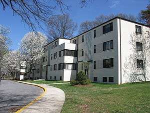 Apartments in Greenbelt
 Extensive pedestrian paths connect residences, in this case feeding into a tunnel beneath the primary collector roadway
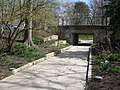 A grade-separated pedestrian path / roadway crossing, inspired by such configurations in Radburn, New Jersey
 Albert S. Buddy Attick Lake Park. The artificial lake replaces the open parkland of the Radburn plan
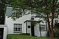 Greenbelt Museum, located in a former home, built 1936-1937, at 15 Crescent Road
 One of several panels by sculptor Lenore Thomas Straus, installed at the Greenbelt Community Center
See also
Further reading
- Cathy D. Knepper (2001), Greenbelt, Maryland: A Living Legacy of the New Deal, Creating the North American Landscape, The Johns Hopkins University Press, ISBN 0-8018-6490-9
- Mary Lou Williamson (editor) (1987), Greenbelt: History of a New Town, 1937–1987, The Donning Company, ISBN 0-89865-607-9
- "Langley Park-College Park-Greenbelt Approved Master Plan (October 1989) and Adopted Sectional Map Amendment." Maryland-National Capital Park and Planning Commission, May 1990. Read online.
External links
- "City of Greenbelt". official website.
- "Greenbelt Community Website". Greenbelt Internet Access Cooperative (GIAC).
- "The Greenbelt Arts Center". Greenbelt Arts Center (GAC).
- "The Greenbelt Museum". The Friends of the Greenbelt Museum (FOGM).
- Virtual Greenbelt at the University of Maryland, College Park
- Greenbelt Volunteer Fire Department
- "Kojo In Your Community: Greenbelt". The Kojo Nnamdi Show, W A M U 8 8 . 5, streaming audio. 2010-04-21.
| Wikivoyage has a travel guide for Greenbelt. |
| Wikimedia Commons has media related to Greenbelt, Maryland. |
| Wikimedia Commons has media related to Albert S. Buddy Attick Lake Park. |
| Wikimedia Commons has media related to Roosevelt Center. |
References
- 1 2 3 4 5 "TIGERweb 5.0 - Greenbelt city, internal point latitude and longitude". United States Census Bureau, Geography Division / Esri. Retrieved 2018-10-02.
- 1 2 3 4 5 "State of Maryland Incorporated Places - Current/ACS18 - Data as of January 1, 2018". tigerweb.geo.census.gov. Retrieved 2018-10-02.
- ↑ Larsen, Christian L.; Andrews, Richard D. (1951). "Origin and Growth". The government of Greenbelt. Baltimore: George W. King Printing Company. pp. 1–8. Retrieved 2018-10-02.
- 1 2 "American FactFinder". United States Census Bureau. Retrieved 2013-01-25.
- 1 2 "U.S. Census Bureau QuickFacts: Greenbelt city, Maryland; UNITED STATES". Census Bureau QuickFacts. Retrieved 2018-09-12.
- 1 2 3 4 5 6 7 8 9 10 Williamson, Mary Lou (1987). Phillips, Nancy O., ed. Greenbelt: History of a New Town, 1937-1987. Norfolk, VA: Donning Co. pp. 1–43. ASIN 0898656079. hdl:2027/mdp.39015061000652. ISBN 0898656079. OCLC 607530163. Lay summary.
- 1 2 3 4 5 "Franklin D. Roosevelt: Executive Order 7027 Establishing the Resettlement Administration". The American Presidency Project. Retrieved 2018-09-13.
- 1 2 "Today in History - April 8". The Library of Congress. Retrieved 2018-09-13.
- ↑ "All Zip Codes in Greenbelt MD". Zip-Codes.com. Datasheer, L.L.C. Retrieved 2018-09-12.
- ↑ "Zip Code 20770, Greenbelt, Maryland Boundary Map Version 4.0". www.zipmap.net. USNaviguide LLC. Retrieved 2018-09-12.
- ↑ "CENSUS 2000 BLOCK MAP: GODDARD CDP." U.S. Census Bureau. Retrieved on September 1, 2018. 1990 Census map of Prince George's County (index map) has Goddard CDP on Page 9.
- ↑ "Driving Directions to the Goddard Visitor Center." Goddard Space Flight Center. Retrieved on September 1, 2018. "8800 Greenbelt Road Greenbelt, MD 20771" - Driving Directions Map, Campus Map
- ↑ "Baltimore–Washington Parkway — Maryland's National Register Properties". Maryland Historical Trust. Retrieved 2018-09-11.
- 1 2 Halpern, Sue (May–June 2002), "New Deal City", Mother Jones, retrieved 2007-07-07
- ↑ "Greendale Originals - The shops, history and events in the Village of Greendale, Wisconsin". Archived from the original on 2012-02-07.
- 1 2 "HOUSING: Greenbelt". Time. 1937-09-13. Retrieved 2010-07-23.
- ↑ "Images and Voices of Greenbelt: Oral Histories". Virtual Greenbelt. University of Maryland. 2000. Archived from the original on 2010-06-07. Retrieved 2010-07-23.
- ↑ Vick, Karl (1997-04-20), "In FDR Years, 'Sleepy Southern Town' Woke Up", The Washington Post, retrieved 2009-11-03
- ↑ "Images and Voices of Greenbelt: Oral Histories". Virtual Greenbelt. University of Maryland. 2000. Archived from the original on 2010-06-13. Retrieved 2010-07-23.
- 1 2 "American FactFinder". United States Census Bureau. Archived from the original on 2013-09-11. Retrieved 2008-01-31.
- ↑ "20770 Zip Code (Greenbelt, Maryland) Profile - homes, apartments, schools, population, income, averages, housing, demographics, location, statistics, sex offenders, residents and real estate info". City-data.com. Retrieved 2016-03-11.
- ↑ "Greenbelt City Government". Greenbelt CityLink. City of Greenbelt, Maryland. Archived from the original on 2008-09-01. Retrieved 2008-08-24.
- ↑ Connor, Jill (2017-11-09), "Byrd Joins Six Incumbents; Both Questions Win Approval" (PDF), Greenbelt News Review, p. 1, retrieved 2018-03-07
- ↑ Gallagher, Kathleen (2017-01-12), "Nicole Ard New City Manager As Michael McLaughlin Retires" (PDF), Greenbelt News Review, pp. 1, 7, retrieved 2018-03-07
- ↑ "ACLU Contacts City re: Reform for Fairness of Election System" (PDF), Greenbelt News Review, pp. 1, 6, 2008-03-27, retrieved 2008-08-24
- ↑ Jeon, Deborah A. (Legal Director, American Civil Liberties Union of Maryland) (2008-02-28). "Letter to the Greenbelt City Council" (PDF). Retrieved 2008-08-24.
- ↑ McLaughlin, Michael (City Manager of Greenbelt) (2008-06-03). "Response to Gazette editorial" (PDF). Archived from the original (PDF) on 2011-07-18. Retrieved 2010-09-27.
- ↑ Attebury, Jordan; Lyles, Jeffrey K. (December 3, 2009), "A change in complexion for Greenbelt", Washington Post, retrieved 2010-01-12
- ↑ McGill, Natalie (June 5, 2008), "Probe of election system begins", Maryland Gazette, retrieved 2008-07-17
- ↑ Woods, Bay (2008-10-09), "NAACP and ACLU Hold Their Third Meeting in Greenbelt West" (PDF), Greenbelt News Review, pp. 1, 6, retrieved 2009-11-07
- ↑ White, Thomas X. (2008-08-28), "County Groups Seek to Change Manner of Voting in Greenbelt" (PDF), Greenbelt News Review, pp. 1, 12, retrieved 2008-09-11
- ↑ Attebury, Jordan (September 24, 2009), "Nine candidates vie for city office", Maryland Gazette, retrieved 2009-11-04
- ↑ Giese, James (2009-11-05), "Jordan, Davis, City Are the Big Winners in City Council Election" (PDF), Greenbelt News Review, pp. 1, 8, retrieved 2009-11-07
- ↑ Attebury, Jordan (November 3, 2009), "Greenbelt elects first black city councilman", Maryland Gazette, retrieved 2009-11-04
- ↑ City of Greenbelt 2009 Election Results, November 4, 2009, archived from the original on January 12, 2010, retrieved 2009-11-04
- ↑ Giese, James (2013-11-07), "Emmett Jordan Gets Top Vote All Incumbents Are Re-elected" (PDF), Greenbelt News Review, pp. 1, 7, retrieved 2013-11-16
- ↑ Oberg, Diane (2013-11-14), "Full House Sees Emmett Jordan Elected and Inducted as Mayor" (PDF), Greenbelt News Review, pp. 1, 6, retrieved 2013-11-16
- ↑ "District 1 Station - Hyattsville. Prince George's County Police Department. Retrieved on September 9, 2018. Beat map.
- ↑ "District 2 Station - Bowie." Prince George's County Police Department. Retrieved on September 9, 2018. "District 2 Station - Bowie 601 SW Crain Highway Bowie, MD 20715 ". Beat map. 2010 U.S. Census Bureau index map of Brock Hall CDP as well as the detail on Page 1.
- ↑ "District 6 Station - Beltsville." Prince George's County Police Department. Retrieved on September 9, 2018. "4321 Sellman Road Beltsville, MD 20704 ". Beat map. See 2010 U.S. Census index map of Beltsville CDP: area with police station is page 3.
- ↑ "GREENBELT." U.S. Postal Service. Retrieved on September 11, 2018. "7600 ORA GLEN DR GREENBELT, MD 20770-9998"
- 1 2 "About Us - Greenbelt Co-op Supermarket and Pharmacy". Greenbelt Co-op Supermarket and Pharmacy. Retrieved 2018-09-12.
- 1 2 "About the Cafe - New Deal Cafe". New Deal Cafe. Retrieved 2018-09-12.
- ↑ "Members - New Deal Cafe". New Deal Cafe. Retrieved 2018-09-12.
- ↑ "Frequently Asked Questions - Greenbelt Co-op Supermarket and Pharmacy". Greenbelt Co-op Supermarket and Pharmacy. Retrieved 2018-09-12.
- ↑ "Schools." City of Greenbelt. Retrieved on September 1, 2018.
- ↑ "2010 CENSUS - CENSUS BLOCK MAP (INDEX): Greenbelt city, MD." U.S. Census Bureau. Retrieved on September 1, 2018.
- ↑ "NEIGHBORHOOD ELEMENTARY SCHOOLS AND BOUNDARIES SCHOOL YEAR 2018-2019." Prince George's County Public Schools. Retrieved on September 1, 2018.
- ↑ "NEIGHBORHOOD MIDDLE SCHOOLS AND BOUNDARIES SCHOOL YEAR 2018-2019." Prince George's County Public Schools. Retrieved on September 1, 2018.
- ↑ "NEIGHBORHOOD HIGH SCHOOLS AND BOUNDARIES SCHOOL YEAR 2018-2019." Prince George's County Public Schools. Retrieved on September 1, 2018.
- ↑ http://www1.pgcps.org/eleanorroosevelt/wipage.aspx?pageid=173868&LangType=1033
- ↑ "Elementary Schools." City of Greenbelt. Retrieved on September 1, 2018. "The Academy of Saint Matthias the Apostle 9473 Annapolis Road Lanham, MD 20706 "
- ↑ "2010 CENSUS - CENSUS BLOCK MAP: Lanham CDP, MD." U.S. Census Bureau. Retrieved on September 1, 2018.
- 1 2 Knepper, Cathy D. Greenbelt, Maryland: A Living Legacy of the New Deal. JHU Press, 2001. ISBN 0801864909, 9780801864902. p. 109.
- 1 2 Afenson-Comeau, Jamie (2012-10-24). "Prince George's officials consider moving French immersion program to shuttered Greenbelt school". The Gazette. Retrieved 2018-09-11.
- ↑ Knepper, Cathy D. Greenbelt, Maryland: A Living Legacy of the New Deal. JHU Press, 2001. ISBN 0801864909, 9780801864902. p. 149.
- ↑ "Greenbelt Branch." Prince George's County Memorial Library System. Retrieved on August 29, 2018. "Greenbelt Branch 11 Crescent Rd Greenbelt, MD 20770"
- ↑