Accident, Maryland
| Accident, Maryland | |
|---|---|
| Town | |
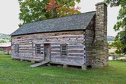 James Drane House in 2012 | |
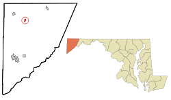 Location of Accident, Maryland | |
| Coordinates: 39°37′41″N 79°19′12″W / 39.62806°N 79.32000°WCoordinates: 39°37′41″N 79°19′12″W / 39.62806°N 79.32000°W | |
| Country |
|
| State |
|
| County |
|
| Patented | 1786[1] |
| Incorporated | 1916[1] |
| Government | |
| • Mayor | Richard Carlson |
| Area[2] | |
| • Total | 0.49 sq mi (1.27 km2) |
| • Land | 0.49 sq mi (1.27 km2) |
| • Water | 0 sq mi (0 km2) |
| Elevation | 2,385 ft (727 m) |
| Population (2010)[3] | |
| • Total | 325 |
| • Estimate (2016)[4] | 316 |
| • Density | 660/sq mi (260/km2) |
| • Demonym | Accidental |
| Time zone | UTC-5 (Eastern (EST)) |
| • Summer (DST) | UTC-4 (EDT) |
| ZIP code | 21520 |
| Area code(s) | 301 |
| FIPS code | 24-00225 |
| GNIS feature ID | 0582858 |
Accident (ˈæk.sə.dɛnt) is a town in Garrett County, Maryland, United States. The population was 325 at the 2010 census. According to the book Labels for Locals by Paul Dickson, the town is the only place in the United States named Accident and a person from Accident is called an "Accidental".[5]
History
Accident was one of the early settlements in the far west of Maryland. The name goes back to the 1786 land survey. Though the origin or meaning of the name is unknown, one popular story says that Brooke Beall and William Deakins, Jr., friends from Prince George's County were conducting separate surveys in the area at the time and "by accident" Deakins claimed land already surveyed by Beall.[1][6]
When Lord Baltimore opened up the area he called Monocacy Manor to settlement in the early 1770s, Brooke Beall secured permission to survey 778 acres (3.15 km2). It will never be known for certain how Beall came to choose this particular spot, but the surveyor was given clear instructions where to start. He was to begin "in the center between two bounded white oak trees, standing on the North Side of the South fork of Bear Creek in or near a glade about one Hundred yards from said Run, about one or two Miles above a Lick known by the name of the "Cole Mine Lick", about four miles (6 km) above the mouth of Broad Creek and about one mile (1.6 km) East of a Ridge of the Negro Mountain." John Hanson, Jr., later a delegate to the Continental Congress, and President of the United States in Congress Assembled, on April 14, 1774, surveyed the land, finding that it only contained 682 acres (2.76 km2). For the next twelve years, nothing was done with the survey. Revolution intervened, and it was not until February 15, 1786, that the land was granted by means of a patent to William Deakins. The following year the surrounding countryside was surveyed into military lots by Francis Deakins, lots that were meant as compensation for the soldiers who served from Maryland during the War of independence. Each soldier who served for two years received one lot of 50 acres (200,000 m2), officers received four lots of 50 acres (200,000 m2) each.[7]

Kaese Mill was listed on the National Register of Historic Places in 1984.[8] The James Drane House was listed in 1985.[8]
Geography
Accident is located at 39°37′41″N 79°19′12″W / 39.62806°N 79.32000°W (39.628074, -79.319996).[9]
According to the United States Census Bureau, the town has a total area of 0.49 square miles (1.27 km2), all land.[2]
Accident is located in the plateau region of the Appalachian mountains.
Demographics
| Historical population | |||
|---|---|---|---|
| Census | Pop. | %± | |
| 1880 | 114 | — | |
| 1940 | 236 | — | |
| 1950 | 242 | 2.5% | |
| 1960 | 237 | −2.1% | |
| 1970 | 237 | 0.0% | |
| 1980 | 246 | 3.8% | |
| 1990 | 349 | 41.9% | |
| 2000 | 353 | 1.1% | |
| 2010 | 325 | −7.9% | |
| Est. 2016 | 316 | [4] | −2.8% |
| U.S. Decennial Census[10] | |||
2010 census
As of the census[3] of 2010, there were 325 people, 141 households, and 86 families residing in the town. The population density was 663.3 inhabitants per square mile (256.1/km2). There were 173 housing units at an average density of 353.1 per square mile (136.3/km2). The racial makeup of the town was 97.8% White, 0.6% Native American, 0.3% Asian, 0.6% from other races, and 0.6% from two or more races. Hispanic or Latino of any race were 0.6% of the population.
There were 141 households of which 33.3% had children under the age of 18 living with them, 45.4% were married couples living together, 11.3% had a female householder with no husband present, 4.3% had a male householder with no wife present, and 39.0% were non-families. 32.6% of all households were made up of individuals and 19.1% had someone living alone who was 65 years of age or older. The average household size was 2.30 and the average family size was 2.99.
The median age in the town was 34.5 years. 26.2% of residents were under the age of 18; 10.1% were between the ages of 18 and 24; 25.3% were from 25 to 44; 22.8% were from 45 to 64; and 15.7% were 65 years of age or older. The gender makeup of the town was 45.5% male and 54.5% female.
2000 census
As of the census[11] of 2000, there were 353 people, 138 households, and 96 families residing in the town. The population density was 711.1 people per square mile (272.6/km²). There were 162 housing units at an average density of 326.3 per square mile (125.1/km²). The racial makeup of the town was 99.72% White and 0.28% from two or more races.
There were 138 households out of which 37.7% had children under the age of 18 living with them, 54.3% were married couples living together, 12.3% had a female householder with no husband present, and 30.4% were non-families. 28.3% of all households were made up of individuals and 21.7% had someone living alone who was 65 years of age or older. The average household size was 2.56 and the average family size was 3.14.
In the town, the population was spread out with 29.2% under the age of 18, 7.1% from 18 to 24, 22.4% from 25 to 44, 18.4% from 45 to 64, and 22.9% who were 65 years of age or older. The median age was 38 years. For every 100 females, there were 73.9 males. For every 100 females age 18 and over, there were 73.6 males.
The median income for a household in the town was $22,500, and the median income for a family was $40,556. Males had a median income of $25,250 versus $18,750 for females. The per capita income for the town was $11,950. About 10.9% of families and 17.5% of the population were below the poverty line, including 17.3% of those under age 18 and 24.1% of those age 65 or over.
Notable people
- Wendell R. Beitzel, member of Maryland House of Delegates
- James Drane, builder and first owner of the historical Drane House
References
- 1 2 3 "Accident". Maryland Manual. Retrieved 24 June 2017.
- 1 2 "US Gazetteer files 2010". United States Census Bureau. Archived from the original on 2012-07-14. Retrieved 2013-01-25.
- 1 2 "American FactFinder". United States Census Bureau. Retrieved 2013-01-25.
- 1 2 "Population and Housing Unit Estimates". Retrieved June 9, 2017.
- ↑ Dickson, Paul (2006). Labels for Locals: What to Call People from Abilene to Zimbabwe. Harper Collins. p. 3. ISBN 9780060881641.
- ↑ "How did this spot get the name "Accident?" Mary Strauss in Flowery Vale: A History of Accident, Maryland,(Parson, West Virginia: McClain Printing Col, 1986), p. 1, provides an interesting story of axe marks on a tree, and conflicting claims, "A Pictorial History of Accident, Maryland, from the collection of Mary Miller Strauss". Western Maryland's Historical Society. Archived from the original on 2007-09-27. Retrieved 2008-03-29.
- ↑ Mr. George Deakins was to receive 600 acres of land in Western Maryland as a payment of a debt from King George II of England. Mr. Deakins sent out two corps of engineers, each without knowledge of the other, to survey the best land in this area. Both crews returned and to their surprise, they had both marked the same Oak tree as their starting and returning points. Mr. Deakins chose this plot of ground and had it patented "The Accident Tract". Now called, the Town of Accident! Accident was incorporated in 1916. Scharf, J. Thomas (1882). History of Western Maryland. Philadelphia: Louis A. Everts
- 1 2 National Park Service (2008-04-15). "National Register Information System". National Register of Historic Places. National Park Service.
- ↑ "US Gazetteer files: 2010, 2000, and 1990". United States Census Bureau. 2011-02-12. Retrieved 2011-04-23.
- ↑ "Census of Population and Housing". Census.gov. Archived from the original on May 12, 2015. Retrieved June 4, 2015.
- ↑ "American FactFinder". United States Census Bureau. Archived from the original on 2013-09-11. Retrieved 2008-01-31.
External links
- Maryland Municipal League: Accident
- Photographs of Accident Western Maryland History Online, Whilbr
- Ruth Enlow Library
- Map of Military Lots, Garrett County, Maryland, 1787 Western Maryland Regional Library.
- http://www.accidentmd.org/
- Accident School
Municipalities and communities of Garrett County, Maryland, United States | ||
|---|---|---|
| Towns | 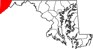 | |
| CDPs | ||
| Unincorporated communities | ||
| Ghost town | ||
| Footnotes | ‡This populated place also has portions in an adjacent county or counties | |