Dubuque County, Iowa
| Dubuque County, Iowa | ||
|---|---|---|
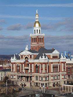 The Dubuque County Courthouse is an example of Beaux-Arts architecture. | ||
| ||
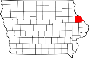 Location in the U.S. state of Iowa | ||
 Iowa's location in the U.S. | ||
| 42°28′15″N 90°52′42″W / 42.47083°N 90.87833°WCoordinates: 42°28′15″N 90°52′42″W / 42.47083°N 90.87833°W | ||
| Founded | 1834 | |
| Named for | Julien Dubuque | |
| Seat | Dubuque | |
| Largest city | Dubuque | |
| Area | ||
| • Total | 617 sq mi (1,598 km2) | |
| • Land | 608 sq mi (1,575 km2) | |
| • Water | 8.3 sq mi (21 km2), 1.4% | |
| Population (est.) | ||
| • (2015) | 97,125 | |
| • Density | 154/sq mi (59/km2) | |
| Congressional district | 1st | |
| Time zone | Central: UTC−6/−5 | |
| Website |
www | |

Dubuque County is a county located in the U.S. state of Iowa. As of the 2010 census, the population was 93,653.[1] The county seat is Dubuque.[2] The county is named for Julien Dubuque, the first European settler of Iowa.
Dubuque County comprises the Dubuque, IA Metropolitan Statistical Area,[3] and is the seventh largest county by population in the state.
History
Early history
Dubuque County is named for French trader Julien Dubuque,[4] the first European settler of Iowa, and an early lead mining pioneer in what is now Dubuque County. Dubuque was French Canadian, and had (by most accounts) a friendly relationship with the local Fox tribe of Native Americans. He and other early pioneers established a lucrative mining and trading industry in the area. When lead deposits began becoming exhausted, the pioneers developed boat building, lumber yards, milling, brewing, and machinery manufacturing to take its place.
The establishment of the City of Dubuque in 1833 led to large-scale settlement of the surrounding area. This was greatly encouraged by the Roman Catholic Church, which sent priests, bishops, and nuns to establish churches in the unpopulated countryside. Primarily, Irish and German (many of whom were Catholic) immigrants came to the region.
At an extra session of the Sixth Legislative Assembly of Michigan Territory held in September, 1834, the Iowa District was divided into two counties by running a line due west from the lower end of Rock Island in the Mississippi River. The territory north of this line (which started just south of the present-day Davenport) was named Dubuque County, and all south of it was Demoine County [sic]. Thus, at that time Dubuque County nominally included not only much of what is now the state of Minnesota but portions of what are now North Dakota and South Dakota.
Dubuque County became part of Wisconsin Territory once it was split off from Michigan Territory on July 3, 1836. A massive reorganization and reduction of the county's size was executed on December 21, 1837, when its original area was separated into 13 named new counties and a "non-county area". The land in present day Minnesota and the Dakotas was transferred to the newly created Fayette County in this action. Dubuque County became a part of Iowa Territory upon its creation on July 4, 1838.[5]
In 1858, Saint Francis Catholic Church was established in Dubuque County.
Middle history
In the 1980s, the farm crisis set in, and devastated large sections of the Midwest, including Dubuque County. Since the area was heavily dependent on agriculture-related industries like Deere and Company and the Dubuque Packing Company, unemployment soared. In one month of 1982, Dubuque County had 23% unemployment, the highest in the nation. The county experienced huge population losses during this time, as workers left the area. It would not fully recover from this until the late 1990s, when the economy diversified, shifting away from manufacturing, and toward various service-related establishments.
Modern history
Since the 1990s, the area has become much more prosperous. Today, the county boasts record employment levels and a growing population. The surging economy can especially be seen in the West Side of the City of Dubuque, and in neighboring Peosta and Asbury. These areas have expanded so much that concerns now lie with trying to manage the growth, a sharp change from just 20 years ago.
It is one of Iowa's two original counties along with Des Moines County; both were organized by the Michigan Territorial legislature in 1834.
The city of Dubuque was chartered in 1833 as the first city in Iowa.
Law and government
Dubuque County is governed by a 3-member Board of Supervisors elected at large. Current supervisors include Wayne Demmer (chairman), Eric Manternach, and Daryl Klein. They meet on alternate Mondays at 9:00 AM or 7:00 PM in the Dubuque County Courthouse.
The County Sheriff's Department is responsible for law enforcement in all areas of the county, especially those without their own police departments. The current county sheriff is Joe Kennedy. The Sheriff's Dept. is located at the Dubuque City/County Law Enforcement Center.
The current county attorney is Ralph Potter, who succeeds the long-serving Fred McCaw, who died while on vacation in 2006.
Geography
Geographic features
The county borders on Illinois and Wisconsin, and is bounded on the northeast by the Mississippi River.[6] According to the U.S. Census Bureau, the county has a total area of 617 square miles (1,600 km2), of which 608 square miles (1,570 km2) is land and 8.3 square miles (21 km2) (1.4%) is water.[7] The county is drained by north and south forks of the Maquoketa River.[6]
The county seat is Dubuque, Iowa, which is located along the Mississippi River in the east-central portion of the county. Eastern Dubuque County is markedly different from the western portion in that its topography is very uneven. The city of Dubuque and surrounding areas adjacent to the Mississippi River have many steep hills, bluffs, and ravines. Also, the eastern portion is more heavily wooded than the west, which is mostly rolling farmland.
Dubuque County is widely known for its impressive bluffs along the Mississippi River, which run along the entire length of the county's riverbanks. These form part of Iowa's Coulee Region, otherwise known as the Driftless Area. During the last ice age, much of the Mississippi Valley near Dubuque County was bypassed by glacial flows, which flattened the surrounding land in eastern Illinois, Wisconsin, and western Iowa, leaving the Driftless Area unusually rugged.
Major parks
The Iowa Department of Natural Resources administers 3 park and preserve areas in the county:
- Little Maquoketa River Mounds State Preserve
- Mines of Spain State Recreation Area/E. B. Lyons Nature Center
- White Pine Hollow State Forest
The Dubuque County Conservation Board administers 11 park and recreation areas in the county:
- Bankston Park
- Fillmore Recreation Area & Fairways
- Finley's Landing Park
- Heritage Trail & Pond
- Interstate Power Forest Preserve
- Massey Marina Park
|
- Mud Lake Park
- New Wine Park
- Pohlman Prairie Preserve
- Swiss Valley Nature Park & Preserve
- Whitewater Canyon Park
The City of Dubuque and other towns in the county also operate public park systems of their own. (see Parks in Dubuque, Iowa)
Major highways
Adjacent counties
- Clayton County (north)
- Grant County, Wisconsin (northeast)
- Jo Daviess County, Illinois (east)
- Jackson County (southeast)
- Jones County (southwest)
- Delaware County (west)
National protected areas
Demographics
| Historical population | |||
|---|---|---|---|
| Census | Pop. | %± | |
| 1850 | 10,841 | — | |
| 1860 | 31,164 | 187.5% | |
| 1870 | 38,969 | 25.0% | |
| 1880 | 42,996 | 10.3% | |
| 1890 | 49,848 | 15.9% | |
| 1900 | 56,403 | 13.1% | |
| 1910 | 57,450 | 1.9% | |
| 1920 | 58,262 | 1.4% | |
| 1930 | 61,214 | 5.1% | |
| 1940 | 63,768 | 4.2% | |
| 1950 | 71,337 | 11.9% | |
| 1960 | 80,048 | 12.2% | |
| 1970 | 90,609 | 13.2% | |
| 1980 | 93,745 | 3.5% | |
| 1990 | 86,403 | −7.8% | |
| 2000 | 89,143 | 3.2% | |
| 2010 | 93,653 | 5.1% | |
| Est. 2016 | 97,003 | [8] | 3.6% |
| U.S. Decennial Census[9] 1790-1960[10] 1900-1990[11] 1990-2000[12] 2010-2013[1] | |||
2010 census
The 2010 census recorded a population of 93,653 in the county, with a population density of 153.9940/sq mi (59.4574/km2). There were 38,951 housing units, of which 36,815 were occupied.[13]
2000 census

At the 2000 census,[14] there were 89,143 people, 33,690 households and 23,111 families residing in the county. The population density was 147 per square mile (57/km²). There were 35,505 housing units at an average density of 58 per square mile (23/km²). The racial makeup of the county was 97.07% White, 0.86% Black or African American, 0.15% Native American, 0.58% Asian, 0.09% Pacific Islander, 0.50% from other races, and 0.76% from two or more races. 1.19% of the population were Hispanic or Latino of any race.
2005 estimates by the census indicated that Dubuque had a population that identified itself as being 95.5% non-Hispanic white, 1.3% African American, 0.7% Asian and 1.5% Latino.[15]
There were 33,690 households of which 33.10% had children under the age of 18 living with them, 56.80% were married couples living together, 8.70% had a female householder with no husband present, and 31.40% were non-families. 26.70% of all households were made up of individuals and 10.80% had someone living alone who was 65 years of age or older. The average household size was 2.51 and the average family size was 3.07.
25.60% of the population were under the age of 18, 10.20% from 18 to 24, 27.20% from 25 to 44, 22.30% from 45 to 64, and 14.70% who were 65 years of age or older. The median age was 36 years. For every 100 females there were 94.40 males. For every 100 females age 18 and over, there were 91.30 males.
The median household income was $39,582 and the median family income was $48,742. Males had a median income of $31,977 versus $22,309 for females. The per capita income for the county was $19,600. About 4.90% of families and 7.80% of the population were below the poverty line, including 7.80% of those under age 18 and 11.00% of those age 65 or over.
Economy
Historically, Dubuque County's economy was driven by heavy industry, including, among others, Deere and Company, and the now-defunct Dubuque Packing Company. However, within the last 15 years, and especially within the last 5 years, the economy has diversified a great deal. Now, alongside manufacturing, which still employs thousands of workers, many county residents work in the tourism/gaming, health care, education, publishing, and financial service sectors.
The county's economy is largely centered around business and industry within the City of Dubuque. With the exception of industrial areas in Cascade, Dyersville, and Peosta, almost all of the rest of the county is rural and agriculturally driven. Some of the key industries in Dubuque County include: Deere and Company, Eagle Window & Door Co., Flexsteel Industries, Mi-T-M Corp., A.Y. McDonald Mfg. Co., Klauer Mfg., Georgia-Pacific, and Swiss Valley Farms, among others. Besides industry, large numbers of people work for the Dubuque Community School District, Mercy Medical Center - Dubuque, Medical Associates, Finley Hospital, Prudential Financial, the City of Dubuque, and Cottingham & Butler.
Growth
Dubuque County has, in recent years, enjoyed job growth, low unemployment, and the rapid expansion of business and commerce. Alongside these positives, the county is beginning to see a growing population, as well. Up from a recent low of 86,403 in 1990, the population is now about 92,000 and growing. This can be seen especially in the West Side of the City of Dubuque, and in nearby Asbury and Peosta. This fact is especially significant, considering that all of the counties surrounding Dubuque County have fewer people now than they did in 1900, with the exception of Grant County, Wisconsin.
Politics
The county is historically Democratic. It has supported the Democratic Party's Presidential candidate from John F. Kennedy to Barack Obama, with President Obama winning the county by slightly over 20 points in 2008.[16] With that stated, in 2016, it was narrowly won by Donald Trump, who became the first Republican to win the county since President Eisenhower in 1956.[17] As part of Iowa's 1st congressional district, it is represented by Republican Rod Blum.
| Year | Republican | Democratic | Third Parties |
|---|---|---|---|
| 2016 | 47.2% 23,460 | 46.0% 22,850 | 6.9% 3,411 |
| 2012 | 41.8% 21,280 | 56.5% 28,768 | 1.7% 846 |
| 2008 | 38.9% 18,651 | 59.7% 28,611 | 1.5% 701 |
| 2004 | 42.7% 20,100 | 56.5% 26,561 | 0.8% 382 |
| 2000 | 40.8% 16,462 | 55.4% 22,341 | 3.8% 1,520 |
| 1996 | 35.2% 13,391 | 54.8% 20,839 | 10.0% 3,821 |
| 1992 | 32.6% 14,007 | 47.8% 20,539 | 19.6% 8,422 |
| 1988 | 37.7% 14,530 | 61.7% 23,797 | 0.6% 220 |
| 1984 | 46.4% 19,239 | 52.7% 21,876 | 0.9% 376 |
| 1980 | 44.9% 18,649 | 45.0% 18,689 | 10.1% 4,201 |
| 1976 | 44.7% 17,459 | 52.6% 20,548 | 2.7% 1,042 |
| 1972 | 47.3% 17,272 | 50.4% 18,417 | 2.3% 832 |
| 1968 | 40.7% 14,197 | 53.5% 18,664 | 5.7% 2,002 |
| 1964 | 29.9% 10,104 | 70.1% 23,695 | 0.1% 24 |
| 1960 | 36.6% 12,740 | 63.3% 22,007 | 0.1% 19 |
| 1956 | 57.4% 17,923 | 42.2% 13,174 | 0.5% 150 |
| 1952 | 55.0% 18,075 | 44.3% 14,542 | 0.7% 228 |
| 1948 | 39.0% 10,111 | 59.9% 15,521 | 1.1% 281 |
| 1944 | 49.1% 12,502 | 50.5% 12,867 | 0.4% 89 |
| 1940 | 51.3% 14,590 | 48.5% 13,805 | 0.2% 46 |
| 1936 | 30.2% 8,275 | 59.5% 16,291 | 10.3% 2,812 |
| 1932 | 25.0% 6,747 | 71.2% 19,210 | 3.9% 1,042 |
| 1928 | 33.3% 9,744 | 66.4% 19,437 | 0.3% 81 |
| 1924 | 32.8% 8,280 | 22.6% 5,718 | 44.6% 11,269 |
| 1920 | 59.2% 12,436 | 36.4% 7,636 | 4.4% 928 |
| 1916 | 47.2% 5,772 | 49.6% 6,063 | 3.2% 388 |
| 1912 | 13.8% 1,620 | 53.2% 6,237 | 33.0% 3,867 |
| 1908 | 39.7% 4,708 | 56.1% 6,645 | 4.2% 502 |
| 1904 | 48.3% 5,485 | 43.3% 4,913 | 8.4% 955 |
| 1900 | 41.1% 4,752 | 57.6% 6,655 | 1.4% 157 |
| 1896 | 43.7% 5,203 | 54.7% 6,510 | 1.6% 185 |
Education
Communities
Cities
Unincorporated communities
- Fillmore
- Key West
- Placid
- Washington Mills
Townships
Dubuque County is divided into seventeen townships:
Population ranking
The population ranking of the following table is based on the 2010 census of Dubuque County.[19]
† county seat
| Rank | City/Town/etc. | Municipal type | Population (2010 Census)
|
|---|---|---|---|
| 1 | † Dubuque | City | 57,637 |
| 2 | Asbury | City | 4,170 |
| 3 | Dyersville (partially in Delaware County) | City | 4,058 |
| 4 | Cascade (partially in Jones County) | City | 2,159 |
| 5 | Epworth | City | 1,860 |
| 6 | Farley | City | 1,537 |
| 7 | Peosta | City | 1,377 |
| 8 | New Vienna | City | 407 |
| 9 | Worthington | City | 401 |
| 10 | Holy Cross | City | 374 |
| 11 | Luxemburg | City | 240 |
| 12 | Rickardsville | City | 182 |
| 13 | Sherrill | City | 177 |
| 14 | Centralia | City | 134 |
| 15 | Sageville | City | 122 |
| 16 | Bernard | City | 112 |
| 17 | Zwingle (partially in Jackson County) | City | 91 |
| 18 | Balltown | City | 68 |
| 19 | Bankston | City | 25 |
| 20 | Durango | City | 22 |
See also
References
- 1 2 "State & County QuickFacts". United States Census Bureau. Archived from the original on July 9, 2011. Retrieved July 16, 2014.
- ↑ "Find a County". National Association of Counties. Archived from the original on 2012-07-12. Retrieved 2011-06-07.
- ↑ "Metropolitan Statistical Area Definitions" (PDF). Archived from the original (PDF) on October 1, 2006. Retrieved January 17, 2007.
- ↑ Gannett, Henry (1905). The Origin of Certain Place Names in the United States. Govt. Print. Off. p. 109.
- ↑ "WI: Individual County Chronologies". publications.newberry.org. Retrieved 2016-09-28.
- 1 2

- ↑ "US Gazetteer files: 2010, 2000, and 1990". United States Census Bureau. 2011-02-12. Retrieved 2011-04-23.
- ↑ "Population and Housing Unit Estimates". Retrieved June 9, 2017.
- ↑ "U.S. Decennial Census". United States Census Bureau. Archived from the original on May 12, 2015. Retrieved July 16, 2014.
- ↑ "Historical Census Browser". University of Virginia Library. Retrieved July 16, 2014.
- ↑ "Population of Counties by Decennial Census: 1900 to 1990". United States Census Bureau. Retrieved July 16, 2014.
- ↑ "Census 2000 PHC-T-4. Ranking Tables for Counties: 1990 and 2000" (PDF). United States Census Bureau. Retrieved July 16, 2014.
- ↑ "Population & Housing Occupancy Status 2010". United States Census Bureau American FactFinder. Retrieved May 9, 2011.
- ↑ "American FactFinder". United States Census Bureau. Archived from the original on 2013-09-11. Retrieved 2008-01-31.
- ↑ Dubuque County QuickFacts from the US Census Bureau Archived 2011-07-09 at WebCite
- ↑ "David Leip's Presidential Atlas (Maps for Iowa by election)". uselectionatlas.org. Retrieved 7 April 2018.
- ↑ "Democrats' Task: Rebuild the Blue Political Wall in Midwest". fortune.com. Retrieved 7 April 2018.
- ↑ Leip, David. "Dave Leip's Atlas of U.S. Presidential Elections". uselectionatlas.org. Retrieved 7 April 2018.
- ↑ "Archived copy". Archived from the original on 2013-12-21. Retrieved 2013-02-10.
External links
| Wikimedia Commons has media related to Dubuque County, Iowa. |
Places adjacent to Dubuque County, Iowa | |
|---|---|
Municipalities and communities of Dubuque County, Iowa, United States | ||
|---|---|---|
| Cities | ||
| Townships | ||
| Unincorporated communities | ||
| Footnotes | ‡This populated place also has portions in an adjacent county or counties | |
