Franklin County, Iowa
| Franklin County, Iowa | |
|---|---|
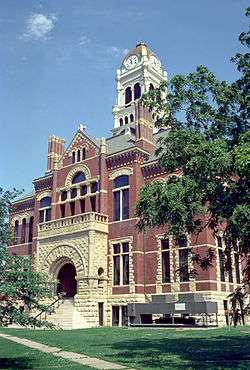 Franklin County Courthouse in Hampton | |
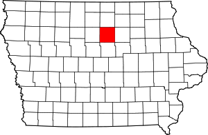 Location in the U.S. state of Iowa | |
 Iowa's location in the U.S. | |
| Founded | 1851 |
| Named for | Benjamin Franklin |
| Seat | Hampton |
| Largest city | Hampton |
| Area | |
| • Total | 583 sq mi (1,510 km2) |
| • Land | 582 sq mi (1,507 km2) |
| • Water | 0.6 sq mi (2 km2), 0.09% |
| Population | |
| • (2010) | 10,680 |
| • Density | 18/sq mi (7/km2) |
| Congressional district | 4th |
| Time zone | Central: UTC−6/−5 |
| Website |
co |
Franklin County is a county located in the U.S. state of Iowa. As of the 2010 census, the population was 10,680.[1] The county seat is Hampton.[2] The county was formed on January 15, 1851[3] and named after Benjamin Franklin.[4]
Geography
According to the U.S. Census Bureau, the county has a total area of 583 square miles (1,510 km2), of which 582 square miles (1,510 km2) is land and 0.6 square miles (1.6 km2) (0.09%) is water.[5]
Major highways
Adjacent counties
- Cerro Gordo County (north)
- Butler County (east)
- Hardin County (south)
- Wright County (west)
Demographics
| Historical population | |||
|---|---|---|---|
| Census | Pop. | %± | |
| 1860 | 1,309 | — | |
| 1870 | 4,738 | 262.0% | |
| 1880 | 10,249 | 116.3% | |
| 1890 | 12,871 | 25.6% | |
| 1900 | 14,996 | 16.5% | |
| 1910 | 14,780 | −1.4% | |
| 1920 | 15,807 | 6.9% | |
| 1930 | 16,382 | 3.6% | |
| 1940 | 16,379 | 0.0% | |
| 1950 | 16,268 | −0.7% | |
| 1960 | 15,472 | −4.9% | |
| 1970 | 13,255 | −14.3% | |
| 1980 | 13,036 | −1.7% | |
| 1990 | 11,364 | −12.8% | |
| 2000 | 10,704 | −5.8% | |
| 2010 | 10,680 | −0.2% | |
| Est. 2016 | 10,170 | [6] | −4.8% |
| U.S. Decennial Census[7] 1790-1960[8] 1900-1990[9] 1990-2000[10] 2010-2013[1] | |||
2010 census
The 2010 census recorded a population of 10,680 in the county, with a population density of 18.338/sq mi (7.080/km2). There were 4,894 housing units, of which 4,332 were occupied.[11]
2000 census

As of the census[12] of 2000, there were 10,704 people, 4,356 households, and 2,983 families residing in the county. The population density was 18 people per square mile (7/km²). There were 4,763 housing units at an average density of 8 per square mile (3/km²). The racial makeup of the county was 94.92% White, 0.08% Black or African American, 0.23% Native American, 0.16% Asian, 0.02% Pacific Islander, 4.05% from other races, and 0.53% from two or more races. 6.00% of the population were Hispanic or Latino of any race.
There were 4,356 households out of which 29.30% had children under the age of 18 living with them, 58.90% were married couples living together, 6.40% had a female householder with no husband present, and 31.50% were non-families. 27.60% of all households were made up of individuals and 15.40% had someone living alone who was 65 years of age or older. The average household size was 2.41 and the average family size was 2.93.
In the county, the population was spread out with 24.20% under the age of 18, 7.30% from 18 to 24, 24.00% from 25 to 44, 23.90% from 45 to 64, and 20.50% who were 65 years of age or older. The median age was 41 years. For every 100 females there were 96.40 males. For every 100 females age 18 and over, there were 93.90 males.
The median income for a household in the county was $36,042, and the median income for a family was $45,184. Males had a median income of $29,694 versus $21,115 for females. The per capita income for the county was $18,767. About 5.70% of families and 8.00% of the population were below the poverty line, including 9.70% of those under age 18 and 7.10% of those age 65 or over.
Franklin County Fair
Franklin County is home to the Franklin County Fair. Held annually for five days in mid-July, the Franklin County Fair is held on the fairgrounds located on the west side of Hampton. Traditionally, grandstand entertainment begins on Wednesday with the Barnes PRCA Rodeo. Thursday, Friday, and Saturday are usually concerts featuring nationally known entertainment. In 2007 such names as Terri Clark, Marshall Tucker Band, and Trent Tomlinson & Danielle Peck brought fans to the grandstand. On Sunday the Figure 8 Races generally fill the grandstand. The fair also includes free entertainment and a carnival midway. The fairgrounds features the Franklin County Historical Museum, Pleasant Hill (turn of the century village with stores, crafters, old west shows, music and entertainment), and Grandpa's Farm (all phases of farming demonstrated with vintage implements powered by draft horses, steam engines and antique tractors).
Education
There are four high schools in Franklin County. The Hampton-Dumont Community School District is a P/K-12 school system located in Hampton and serving the communities of Hampton, Dumont, Aredale, and Hansell. Hampton-Dumont has a K-12 enrollment of 1,194. The West Fork Community Schools are made up of a whole grade sharing agreement between SCMT and Rockwell-Swaledale. West Fork serves the communities of Sheffield, Chapin, Meservey, Thornton, Rockwell, and Swaledale and has a combined enrollment of 764 between the two districts. The AGWSR Community School District serves the communities of Ackley, Geneva, Wellsburg, and Steamboat Rock and has a K-12 enrollment of 654 students. The CAL Community School District, located just south of Latimer, serves the communities of Coulter, Alexander, and Latimer and has a K-12 enrollment of 274 students.
Communities
Cities
Census-designated places
Townships
Franklin County is divided into sixteen townships:
Population ranking
The population ranking of the following table is based on the 2010 census of Franklin County.[13]
† county seat
| Rank | City/Town/etc. | Municipal type | Population (2010 Census)
|
|---|---|---|---|
| 1 | † Hampton | City | 4,461 |
| 2 | Ackley (partially in Hardin County) | City | 1,589 |
| 3 | Sheffield | City | 1,172 |
| 4 | Dows (partially in Wright County) | City | 538 |
| 5 | Latimer | City | 507 |
| 6 | Coulter | City | 281 |
| 7 | Alexander | City | 175 |
| 8 | Geneva | City | 165 |
| 9 | Bradford | CDP | 99 |
| 10 | Hansell | City | 98 |
| 11 | Chapin | CDP | 87 |
| 12 | Popejoy | City | 79 |
Politics
| Year | Republican | Democratic | Third Parties |
|---|---|---|---|
| 2016 | 63.7% 3,163 | 30.1% 1,493 | 6.3% 312 |
| 2012 | 54.4% 2,823 | 43.7% 2,266 | 1.9% 97 |
| 2008 | 48.6% 2,501 | 50.0% 2,575 | 1.4% 73 |
| 2004 | 56.7% 3,128 | 42.4% 2,340 | 1.0% 53 |
| 2000 | 53.8% 2,657 | 43.0% 2,122 | 3.2% 159 |
| 1996 | 43.4% 2,054 | 47.2% 2,232 | 9.4% 447 |
| 1992 | 40.6% 2,137 | 38.9% 2,049 | 20.5% 1,080 |
| 1988 | 46.9% 2,320 | 52.4% 2,594 | 0.8% 37 |
| 1984 | 56.4% 3,129 | 42.4% 2,349 | 1.2% 67 |
| 1980 | 57.9% 3,290 | 33.8% 1,920 | 8.3% 472 |
| 1976 | 52.3% 3,056 | 45.9% 2,682 | 1.8% 105 |
| 1972 | 63.0% 3,643 | 34.3% 1,986 | 2.7% 157 |
| 1968 | 63.5% 3,604 | 31.3% 1,777 | 5.2% 296 |
| 1964 | 40.5% 2,452 | 59.1% 3,582 | 0.5% 27 |
| 1960 | 64.5% 4,514 | 35.4% 2,476 | 0.1% 6 |
| 1956 | 64.4% 4,563 | 35.5% 2,513 | 0.1% 8 |
| 1952 | 72.7% 5,432 | 26.0% 1,941 | 1.3% 97 |
| 1948 | 45.1% 2,716 | 47.7% 2,871 | 7.2% 434 |
| 1944 | 52.0% 3,150 | 47.0% 2,851 | 1.0% 61 |
| 1940 | 49.6% 3,623 | 48.4% 3,540 | 2.0% 147 |
| 1936 | 37.7% 2,530 | 59.6% 3,993 | 2.7% 182 |
| 1932 | 33.0% 2,013 | 61.9% 3,782 | 5.2% 315 |
| 1928 | 65.5% 3,424 | 32.3% 1,688 | 2.1% 112 |
| 1924 | 58.7% 3,064 | 6.9% 360 | 34.4% 1,792 |
| 1920 | 86.1% 4,397 | 11.8% 601 | 2.2% 111 |
| 1916 | 77.2% 2,464 | 21.7% 691 | 1.1% 35 |
| 1912 | 25.2% 773 | 22.6% 694 | 52.2% 1,599 |
| 1908 | 73.0% 2,154 | 25.0% 737 | 2.0% 59 |
| 1904 | 79.6% 2,346 | 18.0% 531 | 2.4% 69 |
| 1900 | 76.4% 2,537 | 22.5% 748 | 1.1% 37 |
| 1896 | 72.6% 2,439 | 26.6% 894 | 0.8% 28 |
See also
- National Register of Historic Places listings in Franklin County, Iowa
- The Franklin County Courthouse in Hampton was built in 1891 and was listed on the National Register of Historic Places in 1976.
Notes
- 1 2 "State & County QuickFacts". United States Census Bureau. Archived from the original on July 10, 2011. Retrieved July 17, 2014.
- ↑ "Find a County". National Association of Counties. Archived from the original on 2011-05-31. Retrieved 2011-06-07.
- ↑ Stuart, I. L. (1914). History of Franklin County, Iowa: A Record of Settlement, Organization, Progress and Achievement, Volume 1. S. J. Clarke Publishing Company. p. 117.
- ↑ Gannett, Henry (1905). The Origin of Certain Place Names in the United States. Govt. Print. Off. p. 131.
- ↑ "US Gazetteer files: 2010, 2000, and 1990". United States Census Bureau. 2011-02-12. Retrieved 2011-04-23.
- ↑ "Population and Housing Unit Estimates". Retrieved June 9, 2017.
- ↑ "U.S. Decennial Census". United States Census Bureau. Archived from the original on May 12, 2015. Retrieved July 17, 2014.
- ↑ "Historical Census Browser". University of Virginia Library. Retrieved July 17, 2014.
- ↑ "Population of Counties by Decennial Census: 1900 to 1990". United States Census Bureau. Retrieved July 17, 2014.
- ↑ "Census 2000 PHC-T-4. Ranking Tables for Counties: 1990 and 2000" (PDF). United States Census Bureau. Retrieved July 17, 2014.
- ↑ "Population & Housing Occupancy Status 2010". United States Census Bureau American FactFinder. Retrieved May 11, 2011.
- ↑ "American FactFinder". United States Census Bureau. Archived from the original on 2013-09-11. Retrieved 2008-01-31.
- ↑ "Archived copy". Archived from the original on 2013-12-21. Retrieved 2013-02-10.
- ↑ Leip, David. "Dave Leip's Atlas of U.S. Presidential Elections". uselectionatlas.org. Retrieved 2018-04-26.
External links
| Wikimedia Commons has media related to Franklin County, Iowa. |
- Official Franklin County Government website
- Franklin County Economic Development website
- Franklin County Convention & Visitor's Bureau Website
- Franklin County Fair
Places adjacent to Franklin County, Iowa | ||||||||||
|---|---|---|---|---|---|---|---|---|---|---|
| ||||||||||
Municipalities and communities of Franklin County, Iowa, United States | ||
|---|---|---|
| Cities | ||
| Townships | ||
| CDPs | ||
| Unincorporated communities | ||
| Footnotes | ‡This populated place also has portions in an adjacent county or counties | |

Coordinates: 42°43′51″N 93°16′03″W / 42.73083°N 93.26750°W