| [3] |
Name on the Register[4] |
Image |
Date listed[5] |
Location |
City or town |
Description |
|---|
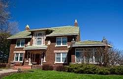
| 1 |
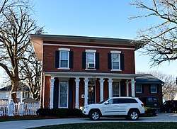
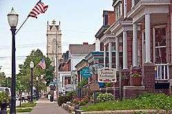
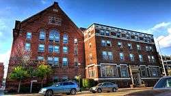
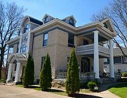
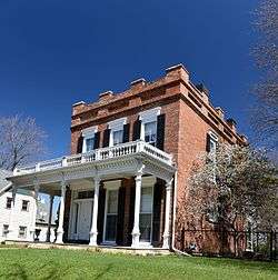
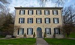
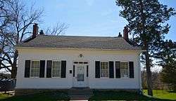
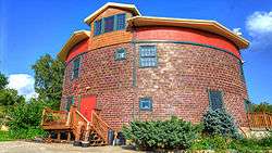
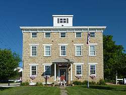
Allen House |
|
July 10, 1975
(#75000686) |
515 1st Ave., W.
42°29′03″N 91°07′50″W / 42.484167°N 91.130556°W / 42.484167; -91.130556 (Allen House) |
Dyersville |
|
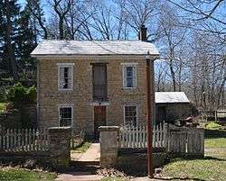
| 2 |
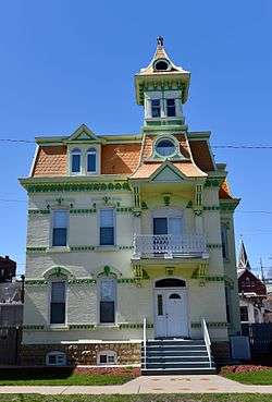
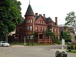
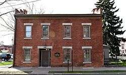
Andrew-Ryan House |
|
April 11, 1985
(#85000720) |
1375 Locust
42°30′17″N 90°40′16″W / 42.504722°N 90.671111°W / 42.504722; -90.671111 (Andrew-Ryan House) |
Dubuque |
|
| 3 |
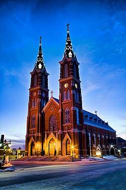
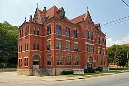
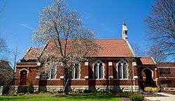
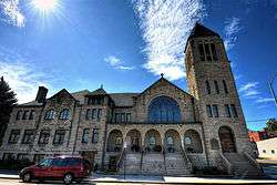
Basilica of St. Francis Xavier, Church and Rectory |
|
September 29, 1999
(#99001205) |
114 Second Street, S.W.
42°29′04″N 91°07′33″W / 42.484436°N 91.125803°W / 42.484436; -91.125803 (Basilica of St. Francis Xavier, Church and Rectory) |
Dyersville |
|
| 4 |
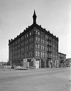
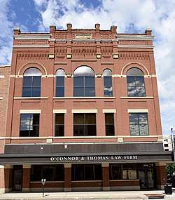
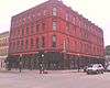
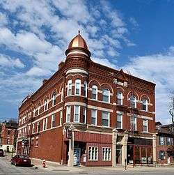
John Bell Block |
|
December 20, 2002
(#02001540) |
1301-07 Central Ave.
42°30′21″N 90°39′59″W / 42.505833°N 90.666389°W / 42.505833; -90.666389 (John Bell Block) |
Dubuque |
|
| 5 |
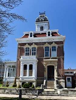
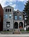
Bishop's Block |
|
May 19, 1994
(#94000477) |
90 W. Main St.
42°29′40″N 90°39′49″W / 42.494444°N 90.663611°W / 42.494444; -90.663611 (Bishop's Block) |
Dubuque |
|
| 6 |
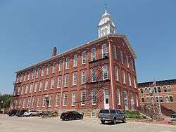
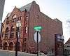
Carnegie-Stout Public Library |
|
August 1, 1975
(#75000684) |
11th and Bluff Sts.
42°30′09″N 90°40′12″W / 42.5025°N 90.67°W / 42.5025; -90.67 (Carnegie-Stout Public Library) |
Dubuque |
|
| 7 |
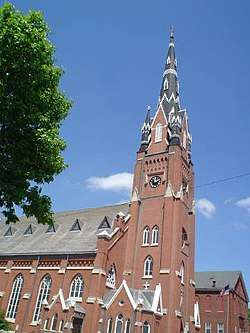
Cathedral Historic District |
|
September 25, 1985
(#85002501) |
Roughly bounded by a bluffline running west of Bluff St., W. 7th, Locust, and Jones Sts.
42°29′48″N 90°40′03″W / 42.496667°N 90.6675°W / 42.496667; -90.6675 (Cathedral Historic District) |
Dubuque |
It includes 96 contributing buildings, including St. Raphael's Cathedral and United States Post Office and Courthouse (Dubuque, Iowa, 1934).[4] |
| 8 |
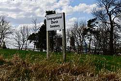
Concord Congregational Cemetery |
|
October 27, 2017
(#100001215) |
21755 N. U.S. Route 52
42°35′09″N 90°54′45″W / 42.585941°N 90.912484°W / 42.585941; -90.912484 (Concord Congregational Cemetery) |
Durango vicinity |
|
| 9 |
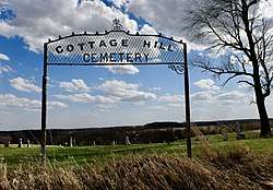
Cottage Hill Methodist-Episcopal Cemetery |
|
June 19, 2017
(#100001216) |
22001 N. U.S. Route 52
42°35′02″N 90°55′04″W / 42.583869°N 90.917730°W / 42.583869; -90.917730 (Cottage Hill Methodist-Episcopal Cemetery) |
Durango |
|
| 10 |
Diamond Jo Boat Store and Office |
|
November 23, 1977
(#77000512) |
Jones and Water Sts.
42°29′35″N 90°39′32″W / 42.49304444°N 90.659025°W / 42.49304444; -90.659025 (Diamond Jo Boat Store and Office) |
Dubuque |
|
| 11 |
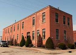
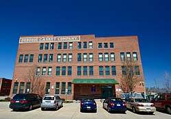
Dubuque Casket Company |
|
February 9, 2006
(#06000003) |
1798 Washington St.
42°30′37″N 90°39′58″W / 42.510249°N 90.666211°W / 42.510249; -90.666211 (Dubuque Casket Company) |
Dubuque |
|
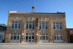
| 12 |
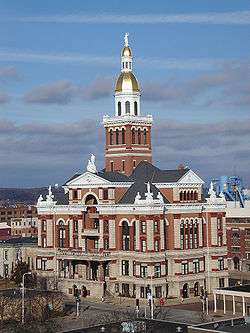
Dubuque City Hall |
|
September 14, 1972
(#72000472) |
50 W. 13th St.
42°30′19″N 90°40′03″W / 42.505278°N 90.6675°W / 42.505278; -90.6675 (Dubuque City Hall) |
Dubuque |
|
| 13 |
Dubuque County Courthouse |
|
June 23, 1971
(#71000298) |
720 Central Ave.
42°30′04″N 90°39′52″W / 42.501111°N 90.664444°W / 42.501111; -90.664444 (Dubuque County Courthouse) |
Dubuque |
part of the County Courthouses in Iowa Thematic Resource (TR) (AD) |
| 14 |
Dubuque County Jail |
|
June 27, 1972
(#72000473) |
36 E. 8th St.
42°30′04″N 90°39′53″W / 42.501111°N 90.664722°W / 42.501111; -90.664722 (Dubuque County Jail) |
Dubuque |
|
| 15 |
Dubuque Freight House |
|
October 11, 1979
(#79003693) |
E. 3rd St. Extension
42°29′46″N 90°39′37″W / 42.496111°N 90.660278°W / 42.496111; -90.660278 (Dubuque Freight House) |
Dubuque |
|
| 16 |
Dubuque Millworking Historic District |
|
November 7, 2008
(#08001030) |
White, Jackson, and Elm between E. 6th and E. 11th Sts.
42°30′11″N 90°39′49″W / 42.5031°N 90.66359°W / 42.5031; -90.66359 (Dubuque Millworking Historic District) |
Dubuque |
part of the Dubuque, Iowa Multiple Property Submission (MPS) |
| 17 |
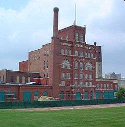
Dubuque Star Brewery |
|
April 24, 2007
(#07000348) |
500 E. 5th St.
42°29′58″N 90°39′15″W / 42.499444°N 90.654167°W / 42.499444; -90.654167 (Dubuque Star Brewery) |
Dubuque |
part of the Dubuque, Iowa MPS |
| 18 |
Dubuque Trading Post-Village of Kettle Chief Archeological District |
|
November 21, 1988
(#88002665) |
Address Restricted
|
Dubuque |
part of the Mines of Spain Archeological MPS |
| 19 |
Dubuque YMCA Building |
|
January 31, 2002
(#01001541) |
125 W. 9th St.
42°30′07″N 90°40′00″W / 42.501944°N 90.666667°W / 42.501944; -90.666667 (Dubuque YMCA Building) |
Dubuque |
|
| 20 |
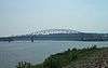
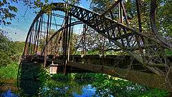
Julien Dubuque Bridge |
|
August 27, 1999
(#99001034) |
U.S. Route 20 over the Mississippi River
42°29′30″N 90°39′17″W / 42.491667°N 90.654722°W / 42.491667; -90.654722 (Julien Dubuque Bridge) |
Dubuque |
part of the Highway Bridges of Iowa MPS |
| 21 |
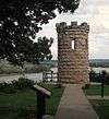
Julien Dubuque Monument |
|
November 21, 1988
(#88002662) |
Confluence of the Mississippi River and Catfish Creek in Mines of Spain State Recreation Area
42°28′07″N 90°38′47″W / 42.468611°N 90.646389°W / 42.468611; -90.646389 (Julien Dubuque Monument) |
Dubuque |
part of the Mines of Spain Archeological MPS |
| 22 |
Dunleith and Dubuque Bridge |
|
September 11, 2013
(#13000690) |
7600 Chavenelle Drive
42°29′21″N 90°46′33″W / 42.489166°N 90.775860°W / 42.489166; -90.775860 (Dunleith and Dubuque Bridge) |
Dubuque |
|
| 23 |
Eagle Point Park Historic District |
|
November 27, 2017
(#100001834) |
2601 Shiras Ave.
42°29′21″N 90°46′33″W / 42.489166°N 90.775860°W / 42.489166; -90.775860 (Eagle Point Park Historic District) |
Dubuque |
|
| 24 |
Epworth School |
|
April 21, 2004
(#04000340) |
310 W. Main St.
42°26′46″N 90°56′08″W / 42.446111°N 90.935556°W / 42.446111; -90.935556 (Epworth School) |
Epworth |
|
| 25 |
Fenelon Place Residential Historic District |
|
November 16, 2015
(#15000787) |
Hill St., 3 & 5th Sts., W., Fenelon Pl., Fenelon Place Elevator
42°29′46″N 90°40′11″W / 42.4962°N 90.6697°W / 42.4962; -90.6697 (Fenelon Place Residential Historic District) |
Dubuque |
|
| 26 |
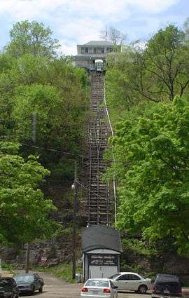
Fenelon Place Elevator |
|
August 3, 1978
(#78001215) |
512 Fenelon Pl.
42°29′47″N 90°40′08″W / 42.496389°N 90.668889°W / 42.496389; -90.668889 (Fenelon Place Elevator) |
Dubuque |
|
| 27 |
Four Mounds Estate Historic District |
|
January 24, 2002
(#01001487) |
4900 Peru Rd.
42°33′21″N 90°40′51″W / 42.555833°N 90.680833°W / 42.555833; -90.680833 (Four Mounds Estate Historic District) |
Dubuque |
|
| 28 |
Four Mounds Site |
|
November 17, 2000
(#00001076) |
Address Restricted
|
Dubuque |
|
| 29 |
Garland House |
|
July 7, 1983
(#83000353) |
1090 Langworthy Ave.
42°29′37″N 90°40′39″W / 42.493611°N 90.6775°W / 42.493611; -90.6775 (Garland House) |
Dubuque |
|
| 30 |
German Bank |
|
March 28, 1978
(#78001216) |
342 Main St.
42°29′50″N 90°39′53″W / 42.497222°N 90.664722°W / 42.497222; -90.664722 (German Bank) |
Dubuque |
|
| 31 |
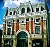
Grand Opera House |
|
September 20, 2002
(#02001029) |
135 8th St.
42°30′06″N 90°39′56″W / 42.501667°N 90.665556°W / 42.501667; -90.665556 (Grand Opera House) |
Dubuque |
part of the Footlights in Farm Country: Iowa Opera Houses MPS |
| 32 |
Haberkorn House and Farmstead |
|
January 25, 1980
(#80001449) |
West of Sherrill
42°36′24″N 90°49′21″W / 42.606667°N 90.8225°W / 42.606667; -90.8225 (Haberkorn House and Farmstead) |
Sherrill |
|
| 33 |
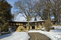
Mathias Ham House |
|
July 19, 1976
(#76000764) |
2241 Lincoln Ave.
42°31′53″N 90°39′02″W / 42.531389°N 90.650556°W / 42.531389; -90.650556 (Mathias Ham House) |
Dubuque |
|
| 34 |
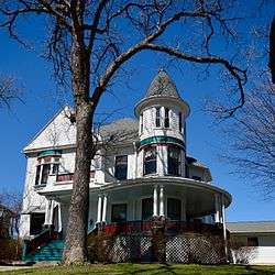
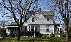
Charles T. Hancock House |
|
April 10, 1986
(#86000741) |
1105 Grove Terr.
42°30′10″N 90°40′17″W / 42.502778°N 90.671389°W / 42.502778; -90.671389 (Charles T. Hancock House) |
Dubuque |
|
| 35 |
Ora Holland House |
|
August 14, 1986
(#86001613) |
1296 Mt. Pleasant St.
42°30′02″N 90°41′04″W / 42.500437°N 90.684507°W / 42.500437; -90.684507 (Ora Holland House) |
Dubuque |
|
| 36 |
Hollenfelz House |
|
September 13, 1977
(#77000513) |
1651 White St.
42°30′30″N 90°40′05″W / 42.508333°N 90.668056°W / 42.508333; -90.668056 (Hollenfelz House) |
Dubuque |
|
| 37 |
Holy Ghost Catholic Historic District |
|
September 15, 2011
(#11000661) |
2887-2921 Central Ave.
42°31′26″N 90°40′46″W / 42.523889°N 90.679444°W / 42.523889; -90.679444 (Holy Ghost Catholic Historic District) |
Dubuque |
part of the Dubuque, Iowa MPS |
| 38 |
Interstate Power Company Building |
|
June 26, 2008
(#08000328) |
1000 Main and 131 W. 10th St.
42°30′09″N 90°40′05″W / 42.50255°N 90.66803°W / 42.50255; -90.66803 (Interstate Power Company Building) |
Dubuque |
part of the Dubuque, Iowa MPS |
| 39 |
Jackson Park Historic District |
|
July 31, 1986
(#86002102) |
Roughly bounded by 17th, Iowa, 10th and 9th, and Bluff and Montrose Sts.
42°30′21″N 90°40′12″W / 42.505833°N 90.67°W / 42.505833; -90.67 (Jackson Park Historic District) |
Dubuque |
|
| 40 |
Kelley House |
|
January 30, 1978
(#78001217) |
274 Southern Ave.
42°29′07″N 90°39′51″W / 42.485278°N 90.664167°W / 42.485278; -90.664167 (Kelley House) |
Dubuque |
|
| 41 |
Zephaniah Kidder House |
|
November 14, 1978
(#78001218) |
206 First Avenue, N.E.
42°26′47″N 90°55′44″W / 42.446389°N 90.928889°W / 42.446389; -90.928889 (Zephaniah Kidder House) |
Epworth |
|
| 42 |
Langworthy Historic District |
|
August 12, 2004
(#04000813) |
Langworthy, W. 3rd, Melrose Terrace, Hill and W. 5th, Alpine and Walnut between Solon and W. 5th
42°29′42″N 90°40′40″W / 42.495°N 90.677778°W / 42.495; -90.677778 (Langworthy Historic District) |
Dubuque |
part of the Dubuque, Iowa MPS |
| 43 |
Langworthy House |
|
October 14, 1975
(#75000685) |
1095 West Third Street
42°29′42″N 90°40′45″W / 42.495°N 90.679167°W / 42.495; -90.679167 (Langworthy House) |
Dubuque |
|
| 44 |
Lincoln School |
|
July 24, 1975
(#75000687) |
About 4 miles (6.4 km) north of Farley
42°29′24″N 90°59′07″W / 42.49°N 90.985278°W / 42.49; -90.985278 (Lincoln School) |
Farley |
|
| 45 |
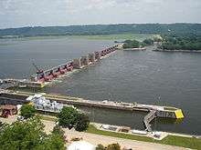
Lock and Dam No. 11 Historic District |
|
March 10, 2004
(#04000171) |
11 Lime St.
42°32′03″N 90°38′44″W / 42.53411°N 90.64542°W / 42.53411; -90.64542 (Lock and Dam No. 11 Historic District) |
Dubuque |
part of the Upper Mississippi River 9-Foot Navigation Project MPS |
| 46 |
T. Ben Loetscher House |
|
November 2, 1989
(#89001777) |
160 S. Grandview Ave.
42°29′25″N 90°41′02″W / 42.490278°N 90.683889°W / 42.490278; -90.683889 (T. Ben Loetscher House) |
Dubuque |
|
| 47 |
McMahon House |
|
November 21, 1976
(#76000765) |
800 English Lane
42°28′48″N 90°40′19″W / 42.48°N 90.671944°W / 42.48; -90.671944 (McMahon House) |
Dubuque |
|
| 48 |
Memorial Building |
|
April 9, 2013
(#13000148) |
340 1st Ave., E.
42°29′05″N 91°07′15″W / 42.48463°N 91.120751°W / 42.48463; -91.120751 (Memorial Building) |
Dyersville |
|
| 49 |
Mines of Spain Area Rural Community Archeological District |
|
November 21, 1988
(#88002663) |
Address Restricted
|
Dubuque |
part of the Mines of Spain Archeological MPS |
| 50 |
Mines of Spain Lead Mining Community Archeological District |
|
November 21, 1988
(#88002664) |
Address Restricted
|
Dubuque |
part of the Mines of Spain Archeological MPS |
| 51 |
Mines of Spain Prehistoric District |
|
November 21, 1988
(#88002666) |
Address Restricted
|
Dubuque |
part of the Mines of Spain Archeological MPS |
| 52 |
Mount Saint Bernard Seminary and Barn |
|
November 5, 1974
(#74000784) |
10336 Military Rd.
42°26′36″N 90°41′36″W / 42.443333°N 90.693333°W / 42.443333; -90.693333 (Mount Saint Bernard Seminary and Barn) |
Dubuque |
|
| 53 |
Old Chapel Hall |
|
August 5, 1983
(#83000355) |
2050 University Ave.
42°29′55″N 90°41′34″W / 42.498611°N 90.692778°W / 42.498611; -90.692778 (Old Chapel Hall) |
Dubuque |
|
| 54 |
Old Main Historic District |
|
January 12, 1983
(#83000356) |
Main St. between 1st and 4th Sts.
42°29′47″N 90°39′53″W / 42.496389°N 90.664722°W / 42.496389; -90.664722 (Old Main Historic District) |
Dubuque |
Boundary increase 2015-10-13 |
| 55 |
Orpheum Theatre and Site |
|
November 14, 1972
(#72000474) |
405 Main St.
42°29′52″N 90°39′55″W / 42.497778°N 90.665278°W / 42.497778; -90.665278 (Orpheum Theatre and Site) |
Dubuque |
|
| 56 |
Johann Christian Frederick Rath House |
|
April 11, 1977
(#77000514) |
1204 Mt. Loretta Ave.
42°29′04″N 90°40′29″W / 42.484444°N 90.674722°W / 42.484444; -90.674722 (Johann Christian Frederick Rath House) |
Dubuque |
|
| 57 |
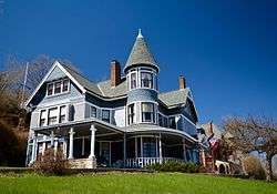
Redstone |
|
December 12, 1976
(#76000766) |
504 Bluff St.
42°29′49″N 90°40′03″W / 42.496944°N 90.6675°W / 42.496944; -90.6675 (Redstone) |
Dubuque |
|
| 58 |
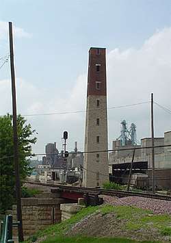
George W. Rogers Company Shot Tower |
|
November 7, 1976
(#76000767) |
Commercial St. and riverfront
42°30′01″N 90°39′18″W / 42.500278°N 90.655°W / 42.500278; -90.655 (George W. Rogers Company Shot Tower) |
Dubuque |
|
| 59 |
Roshek Brothers Department Store |
|
March 17, 2010
(#10000076) |
250 W. 8th St.
42°30′01″N 90°40′08″W / 42.500386°N 90.668806°W / 42.500386; -90.668806 (Roshek Brothers Department Store) |
Dubuque |
|
| 60 |
Round Barn, Dubuque Township |
|
June 30, 1986
(#86001425) |
2810 Cascade Rd.
42°28′24″N 90°42′27″W / 42.473333°N 90.7075°W / 42.473333; -90.7075 (Round Barn, Dubuque Township) |
Dubuque Township |
part of the Iowa Round Barns: The Sixty Year Experiment TR |
| 61 |
Sacred Heart School |
|
June 1, 2018
(#100002486) |
2238 Queen St.
42°31′01″N 90°40′02″W / 42.516875°N 90.667199°W / 42.516875; -90.667199 (Sacred Heart School) |
Dubuque |
|
| 62 |
St. Boniface of New Vienna Historic District |
|
September 29, 1999
(#99001207) |
7401 Columbus St.
42°33′03″N 91°06′54″W / 42.550833°N 91.115°W / 42.550833; -91.115 (St. Boniface of New Vienna Historic District) |
New Vienna |
|
| 63 |
St. Luke's Methodist Episcopal Church |
|
April 23, 1998
(#98000387) |
1199 Main St.
42°30′13″N 90°40′09″W / 42.503611°N 90.669167°W / 42.503611; -90.669167 (St. Luke's Methodist Episcopal Church) |
Dubuque |
|
| 64 |
St. Mary's Catholic Church Historic District |
|
July 21, 2015
(#15000436) |
105 E. 15th, 1584 White, 1501 & 1561 Jackson Sts.
42°30′29″N 90°40′01″W / 42.507990°N 90.666916°W / 42.507990; -90.666916 (St. Mary's Catholic Church Historic District) |
Dubuque |
|
| 65 |
Sauser-Lane House |
|
July 14, 1983
(#83000354) |
101 2nd Ave., SW.
42°17′52″N 91°00′43″W / 42.297778°N 91.011944°W / 42.297778; -91.011944 (Sauser-Lane House) |
Cascade |
|
| 66 |
Schroeder-Klein Grocery Company Warehouse |
|
February 28, 2011
(#11000051) |
40-48 Main St.
42°29′34″N 90°39′46″W / 42.492778°N 90.662778°W / 42.492778; -90.662778 (Schroeder-Klein Grocery Company Warehouse) |
Dubuque |
part of the Dubuque, Iowa MPS |
| 67 |
John and Marie (Palen) Schrup Farmstead Historic District |
|
September 16, 2009
(#09000713) |
10086 Lake Eleanor Rd.
42°25′24″N 90°39′35″W / 42.423294°N 90.659653°W / 42.423294; -90.659653 (John and Marie (Palen) Schrup Farmstead Historic District) |
Dubuque |
|
| 68 |
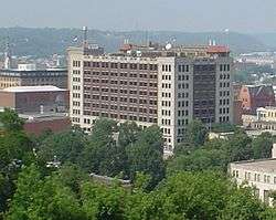
Security Building |
|
August 8, 2006
(#06000681) |
800 Main St.
42°30′04″N 90°40′01″W / 42.501111°N 90.666944°W / 42.501111; -90.666944 (Security Building) |
Dubuque |
part of the Dubuque, Iowa MPS |
| 69 |
Seminary Hill Residential Historic District |
|
October 13, 2015
(#15000723) |
Clarke Dr., N. Main & Madison Sts., Madison Park
42°30′33″N 90°40′19″W / 42.5092°N 90.6719°W / 42.5092; -90.6719 (Seminary Hill Residential Historic District) |
Dubuque |
|
| 70 |
Sherrill Mount House |
|
July 11, 2002
(#02000760) |
5259 S. Mound Rd.
42°36′15″N 90°47′33″W / 42.604167°N 90.7925°W / 42.604167; -90.7925 (Sherrill Mount House) |
Sherrill |
1856; Jesse James reportedly stayed here; now the Black Horse Inn |
| 71 |
J.H. Thedinga House |
|
November 7, 1976
(#76000768) |
340 W. 5th St.
42°29′51″N 90°40′04″W / 42.4975°N 90.667778°W / 42.4975; -90.667778 (J.H. Thedinga House) |
Dubuque |
|
| 72 |
Town Clock Building |
|
January 24, 2002
(#01001488) |
823-25 Main St.
42°30′04″N 90°40′02″W / 42.501111°N 90.667222°W / 42.501111; -90.667222 (Town Clock Building) |
Dubuque |
|
| 73 |
Upper Central Avenue Commercial Historic District |
|
September 19, 2012
(#12000793) |
1460-1965 Central Ave.
42°30′32″N 90°40′09″W / 42.508766°N 90.669084°W / 42.508766; -90.669084 (Upper Central Avenue Commercial Historic District) |
Dubuque |
part of the Dubuque, Iowa MPS |
| 74 |
Upper Iowa Street Historic District |
|
October 13, 2015
(#15000724) |
Iowa St. between W. 11th & 12th Sts.
42°30′15″N 90°40′03″W / 42.5041°N 90.6676°W / 42.5041; -90.6676 (Upper Iowa Street Historic District) |
Dubuque |
|
| 75 |
Upper Main Street Historic District |
|
April 11, 2005
(#05000275) |
1000 and 1100 blocks of Main St.
• Boundary increase (listed February 11, 2011, refnum 11000003): 909, 951, 955, 965 Main St.
42°30′07″N 90°40′05″W / 42.501944°N 90.668056°W / 42.501944; -90.668056 (Upper Main Street Historic District) |
Dubuque |
part of the Dubuque, Iowa MPS |
| 76 |
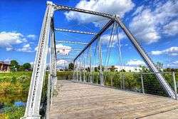
Washington Mill Bridge |
|
June 25, 1998
(#98000788) |
Creek Branch Ln. over Lytle Creek
42°18′15″N 90°46′49″W / 42.304167°N 90.780278°W / 42.304167; -90.780278 (Washington Mill Bridge) |
Bernard |
part of the Highway Bridges of Iowa MPS |
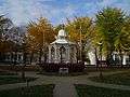
| 77 |
Washington Park |
|
July 14, 1977
(#77000515) |
Bounded by 6th, 7th, Bluff, and Locust Sts.
42°29′57″N 90°40′05″W / 42.499167°N 90.668056°W / 42.499167; -90.668056 (Washington Park) |
Dubuque |
|
| 78 |
Washington Street and East 22nd Street Historic District |
|
February 28, 2011
(#11000052) |
2162-2255 Washington St. and E. 22nd St.
42°30′52″N 90°40′08″W / 42.514444°N 90.668889°W / 42.514444; -90.668889 (Washington Street and East 22nd Street Historic District) |
Dubuque |
part of the Dubuque, Iowa MPS |
| 79 |
Washington Residential Historic District |
|
October 13, 2015
(#15000725) |
1100 - 1900 blks. White, Jackson & Washington Sts.
42°30′27″N 90°39′59″W / 42.5076°N 90.6664°W / 42.5076; -90.6664 (Washington Residential Historic District) |
Dubuque |
|
| 80 |
West Eleventh Street Historic District |
|
August 12, 2004
(#04000814) |
Bounded by Grove Terrace, Loras Boulevard, and Wilbur and Walnut Sts.
42°30′09″N 90°40′25″W / 42.502392°N 90.673644°W / 42.502392; -90.673644 (West Eleventh Street Historic District) |
Dubuque |
part of the Dubuque, Iowa MPS |
| 81 |
Western Hotel |
|
November 7, 1976
(#76000769) |
Southeast of Holy Cross on U.S. Route 52
42°35′36″N 90°58′52″W / 42.593333°N 90.981111°W / 42.593333; -90.981111 (Western Hotel) |
Holy Cross |
|
| 82 |
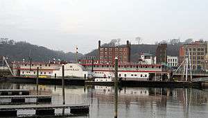
William M. Black (dredge) |
|
April 12, 1982
(#82002618) |
E. 2nd St.
42°29′44″N 90°39′37″W / 42.495556°N 90.660278°W / 42.495556; -90.660278 (William M. Black (dredge)) |
Dubuque |
|
| 83 |
Ziepprecht Block |
|
December 20, 2002
(#02001541) |
1347-53 Central Ave.
42°30′21″N 90°39′59″W / 42.505833°N 90.666389°W / 42.505833; -90.666389 (Ziepprecht Block) |
Dubuque |
|

.jpg)


.jpg)


.jpg)
.jpg)