Crawford County, Iowa
| Crawford County, Iowa | |
|---|---|
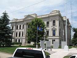 County Courthouse, Denison | |
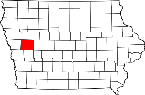 Location in the U.S. state of Iowa | |
 Iowa's location in the U.S. | |
| Founded | 1851/1855 |
| Named for | William Harris Crawford |
| Seat | Denison |
| Largest city | Denison |
| Area | |
| • Total | 715 sq mi (1,852 km2) |
| • Land | 714 sq mi (1,849 km2) |
| • Water | 0.8 sq mi (2 km2), 0.1% |
| Population (est.) | |
| • (2015) | 17,094 |
| • Density | 24/sq mi (9/km2) |
| Congressional district | 4th |
| Time zone | Central: UTC−6/−5 |
Crawford County is a county located in the U.S. state of Iowa. As of the 2010 census, the population was 17,096.[1] Its county seat is Denison.[2] The county was named for William Harris Crawford,[3] U.S. senator from Georgia and United States Secretary of the Treasury.
History
In January 1851, the Iowa Legislature authorized the creation of 50 additional counties in the state. Due to its lack of inhabitants, the designated Crawford County area was attached to Shelby County for purposes of revenue, taxation, and judicial matters.
In 1855 there were sufficient settlers, who petitioned for separation from Shelbgy. This was granted, and a county governing structure was established.[4] The county as then designated did not include its present western townships.
In 1865, four eastern townships of Monona County were separated from that county and incorporated into Crawford County's boundary.[4]
After several adjustments and reorganizations, the present arrangement of Crawford County townships was completed in June 1872.[4]
Geography
According to the US Census Bureau, the county has a total area of 715 square miles (1,850 km2), of which 714 square miles (1,850 km2) is land and 0.8 square miles (2.1 km2) (0.1%) is water.[5]
Major highways
.svg.png)
.svg.png)


Adjacent counties
- Ida County − north
- Sac County − northeast
- Carroll County − east
- Audubon County − southeast
- Shelby County − south
- Harrison County − southwest
- Monona County − west
- Woodbury County − northwest
Demographics
| Historical population | |||
|---|---|---|---|
| Census | Pop. | %± | |
| 1860 | 383 | — | |
| 1870 | 2,530 | 560.6% | |
| 1880 | 12,413 | 390.6% | |
| 1890 | 18,894 | 52.2% | |
| 1900 | 21,685 | 14.8% | |
| 1910 | 20,041 | −7.6% | |
| 1920 | 20,614 | 2.9% | |
| 1930 | 21,028 | 2.0% | |
| 1940 | 20,538 | −2.3% | |
| 1950 | 19,741 | −3.9% | |
| 1960 | 18,569 | −5.9% | |
| 1970 | 19,116 | 2.9% | |
| 1980 | 18,935 | −0.9% | |
| 1990 | 16,775 | −11.4% | |
| 2000 | 16,942 | 1.0% | |
| 2010 | 17,096 | 0.9% | |
| Est. 2016 | 16,940 | [7] | −0.9% |
| US Decennial Census[8] 1790-1960[9] 1900-1990[10] 1990-2000[11] 2010-2013[1] | |||
2010 census
The 2010 census recorded a population of 17,096 in the county, with a population density of 23.944/sq mi (9.245/km2). There were 6,943 housing units, of which 6,413 were occupied.[12]
2000 census

As of the census[13] of 2000, there were 16,942 people, 6,441 households, and 4,489 families residing in the county. The population density was 24 people per square mile (9/km²). There were 6,958 housing units at an average density of 10 per square mile (4/km²). The racial makeup of the county was 93.10% White, 0.76% Black or African American, 0.28% Native American, 0.49% Asian, 0.01% Pacific Islander, 4.59% from other races, and 0.77% from two or more races. 8.75% of the population were Hispanic or Latino of any race.
There were 6,441 households out of which 31.60% had children under the age of 18 living with them, 58.50% were married couples living together, 7.00% had a female householder with no husband present, and 30.30% were non-families. 26.20% of all households were made up of individuals and 13.10% had someone living alone who was 65 years of age or older. The average household size was 2.53 and the average family size was 3.03.
In the county, the population was spread out with 26.50% under the age of 18, 8.10% from 18 to 24, 25.70% from 25 to 44, 22.50% from 45 to 64, and 17.10% who were 65 years of age or older. The median age was 38 years. For every 100 females there were 100.90 males. For every 100 females age 18 and over, there were 98.80 males.
The median income for a household in the county was $33,922, and the median income for a family was $40,231. Males had a median income of $28,696 versus $19,798 for females. The per capita income for the county was $15,851. About 6.90% of families and 11.10% of the population were below the poverty line, including 12.70% of those under age 18 and 5.60% of those age 65 or over.
Communities
Cities
Former Cities
Townships
Population ranking
The population ranking of the following table is based on the 2010 census of Crawford County.[16]
† county seat
| Rank | City/Town/etc. | Municipal type | Population (2010 Census)
|
|---|---|---|---|
| 1 | † Denison | City | 8,298 |
| 2 | Schleswig | City | 882 |
| 3 | Manilla | City | 776 |
| 4 | Dow City | City | 510 |
| 5 | Charter Oak | City | 502 |
| 6 | Vail | City | 436 |
| 7 | Westside | City | 299 |
| 8 | Kiron | City | 279 |
| 9 | Deloit | City | 264 |
| 10 | Ricketts | City | 145 |
| 11 | Arion | City | 108 |
| 12 | Buck Grove | City | 43 |
| 13 | Aspinwall | City | 40 |
Politics
| Year | Republican | Democratic | Third Parties |
|---|---|---|---|
| 2016 | 66.6% 4,617 | 28.7% 1,991 | 4.7% 327 |
| 2012 | 53.2% 3,595 | 45.4% 3,066 | 1.4% 91 |
| 2008 | 46.5% 3,345 | 51.7% 3,715 | 1.8% 131 |
| 2004 | 54.6% 3,955 | 44.5% 3,220 | 0.9% 67 |
| 2000 | 53.1% 3,482 | 43.3% 2,838 | 3.6% 235 |
| 1996 | 40.0% 2,686 | 46.8% 3,140 | 13.2% 889 |
| 1992 | 35.1% 2,693 | 39.2% 3,004 | 25.7% 1,975 |
| 1988 | 46.2% 3,375 | 52.9% 3,868 | 0.9% 68 |
| 1984 | 56.5% 4,552 | 42.2% 3,396 | 1.3% 105 |
| 1980 | 61.0% 4,883 | 31.2% 2,500 | 7.7% 619 |
| 1976 | 48.8% 3,879 | 49.1% 3,903 | 2.1% 166 |
| 1972 | 58.6% 4,493 | 39.4% 3,018 | 2.0% 156 |
| 1968 | 55.4% 4,287 | 36.8% 2,851 | 7.8% 606 |
| 1964 | 37.3% 2,999 | 62.5% 5,024 | 0.2% 14 |
| 1960 | 56.3% 4,791 | 43.7% 3,720 | 0.1% 7 |
| 1956 | 55.0% 4,608 | 44.8% 3,749 | 0.2% 17 |
| 1952 | 63.7% 5,646 | 35.0% 3,107 | 1.3% 115 |
| 1948 | 43.7% 3,267 | 53.2% 3,983 | 3.1% 235 |
| 1944 | 56.5% 4,242 | 42.9% 3,218 | 0.7% 49 |
| 1940 | 55.9% 5,284 | 43.7% 4,130 | 0.4% 35 |
| 1936 | 37.0% 3,514 | 60.2% 5,720 | 2.8% 268 |
| 1932 | 26.1% 2,334 | 68.0% 6,084 | 5.9% 524 |
| 1928 | 43.1% 3,436 | 56.3% 4,495 | 0.6% 50 |
| 1924 | 36.3% 2,882 | 15.8% 1,255 | 48.0% 3,812 |
| 1920 | 68.7% 5,473 | 27.0% 2,151 | 4.4% 348 |
| 1916 | 58.3% 2,756 | 40.6% 1,919 | 1.2% 55 |
| 1912 | 25.0% 1,169 | 47.0% 2,193 | 28.0% 1,308 |
| 1908 | 47.3% 2,169 | 50.6% 2,322 | 2.1% 97 |
| 1904 | 54.1% 2,530 | 42.8% 2,004 | 3.1% 144 |
| 1900 | 45.7% 2,268 | 52.0% 2,578 | 2.3% 115 |
| 1896 | 47.0% 2,189 | 51.4% 2,396 | 1.6% 74 |
See also
References
- 1 2 "State & County QuickFacts". US Census Bureau. Retrieved 14 July 2014.
- ↑ "Find a County". National Association of Counties. Archived from the original on 31 May 2011. Retrieved 7 June 2011.
- ↑ Gannett, Henry (1905). The Origin of Certain Place Names in the United States. Govt. Print. Off. p. 95.
- 1 2 3 Crawford County, Iowa – Establishment of Townships
- ↑ "US Gazetteer files: 2010, 2000, and 1990". US Census Bureau. 12 February 2011. Retrieved 23 April 2011.
- ↑ Crawford County IA Google Maps (accessed 27 August 2018)
- ↑ "Population and Housing Unit Estimates". Retrieved 9 June 2017.
- ↑ "US Decennial Census". US Census Bureau. Archived from the original on 12 May 2015. Retrieved 14 July 2014.
- ↑ "Historical Census Browser". University of Virginia Library. Retrieved 14 July 2014.
- ↑ "Population of Counties by Decennial Census: 1900 to 1990". US Census Bureau. Retrieved 14 July 2014.
- ↑ "Census 2000 PHC-T-4. Ranking Tables for Counties: 1990 and 2000" (PDF). US Census Bureau. Retrieved 14 July 2014.
- ↑ "Population and Housing Occupancy Status: 2010 - State -- County". US Census Bureau − American FactFinder. Retrieved 12 March 2011.
- ↑ "American FactFinder". US Census Bureau. Archived from the original on 11 September 2013. Retrieved 31 January 2008.
- ↑ Astor
- ↑ Kenwood
- ↑ "Archived copy". Archived from the original on 21 December 2013. Retrieved 29 December 2015.
- ↑ Leip, David. "Dave Leip's Atlas of US Presidential Elections". uselectionatlas.org. Retrieved 25 April 2018.
External links
| Wikimedia Commons has media related to Crawford County, Iowa. |
Places adjacent to Crawford County, Iowa | ||||||||||
|---|---|---|---|---|---|---|---|---|---|---|
| ||||||||||
Municipalities and communities of Crawford County, Iowa, United States | ||
|---|---|---|
| Cities | ||
| Townships | ||
| Unincorporated communities | ||
| Footnotes | ‡This populated place also has portions in an adjacent county or counties | |

Coordinates: 42°02′14″N 95°22′43″W / 42.03722°N 95.37861°W