Clay County, Iowa
| Clay County, Iowa | |
|---|---|
 | |
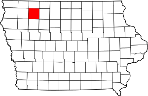 Location in the U.S. state of Iowa | |
 Iowa's location in the U.S. | |
| Founded | 1851 |
| Named for | Henry Clay Jr. |
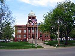
| Seat | Spencer |
| Largest city | Spencer |
| Area | |
| • Total | 573 sq mi (1,484 km2) |
| • Land | 567 sq mi (1,469 km2) |
| • Water | 5.4 sq mi (14 km2), 0.9% |
| Population (est.) | |
| • (2015) | 16,507 |
| • Density | 29/sq mi (11/km2) |
| Congressional district | 4th |
| Time zone | Central: UTC−6/−5 |
| Website |
www |
Clay County is a county located in the U.S. state of Iowa. As of the 2010 census, the population was 16,667.[1] Its county seat is Spencer.[2] Its name is in honor of Henry Clay, Jr.,[3] a colonel who died in action in the Mexican–American War, and son of Henry Clay, famous American statesman from Kentucky.
Clay County comprises the Spencer, IA Micropolitan Statistical Area.
Clay County holds the annual Clay County Fair. The first newspaper in Clay County was the Peterson Patriot which started publication in 1880.
Geography
According to the U.S. Census Bureau, the county has a total area of 573 square miles (1,480 km2), of which 567 square miles (1,470 km2) is land and 5.4 square miles (14 km2) (0.9%) is water.[4] Clay County is home to the large Barringer Slough wetland.
Major highways
Adjacent counties
- Dickinson County (north)
- Palo Alto County (east)
- Buena Vista County (south)
- O'Brien County (west)
Demographics
| Historical population | |||
|---|---|---|---|
| Census | Pop. | %± | |
| 1860 | 52 | — | |
| 1870 | 1,523 | 2,828.8% | |
| 1880 | 4,248 | 178.9% | |
| 1890 | 9,309 | 119.1% | |
| 1900 | 13,401 | 44.0% | |
| 1910 | 12,766 | −4.7% | |
| 1920 | 15,660 | 22.7% | |
| 1930 | 16,107 | 2.9% | |
| 1940 | 17,762 | 10.3% | |
| 1950 | 18,103 | 1.9% | |
| 1960 | 18,504 | 2.2% | |
| 1970 | 18,464 | −0.2% | |
| 1980 | 19,576 | 6.0% | |
| 1990 | 17,585 | −10.2% | |
| 2000 | 17,372 | −1.2% | |
| 2010 | 16,667 | −4.1% | |
| Est. 2016 | 16,333 | [5] | −2.0% |
| U.S. Decennial Census[6] 1790-1960[7] 1900-1990[8] 1990-2000[9] 2010-2013[1] | |||
2010 census
The 2010 census recorded a population of 16,667 in the county, with a population density of 29.292/sq mi (11.310/km2). There were 8,062 housing units, of which 7,282 were occupied.[10]
2000 census
As of the census[11] of 2000, there were 17,372 people, 7,259 households, and 4,776 families residing in the county. The population density was 30 people per square mile (12/km²). There were 7,828 housing units at an average density of 14 per square mile (5/km²). The racial makeup of the county was 98.08% White, 0.17% Black or African American, 0.10% Native American, 0.82% Asian, 0.03% Pacific Islander, 0.25% from other races, and 0.55% from two or more races. 1.13% of the population were Hispanic or Latino of any race.
There were 7,259 households out of which 30.70% had children under the age of 18 living with them, 55.60% were married couples living together, 6.80% had a female householder with no husband present, and 34.20% were non-families. 29.80% of all households were made up of individuals and 13.70% had someone living alone who was 65 years of age or older. The average household size was 2.35 and the average family size was 2.92.
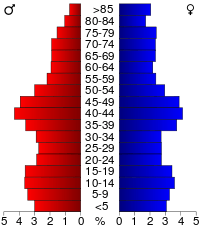
In the county, the population was spread out with 24.70% under the age of 18, 8.00% from 18 to 24, 26.90% from 25 to 44, 22.50% from 45 to 64, and 18.00% who were 65 years of age or older. The median age was 39 years. For every 100 females, there were 93.30 males. For every 100 females age 18 and over, there were 90.90 males.
The median income for a household in the county was $35,799, and the median income for a family was $42,769. Males had a median income of $30,163 versus $21,068 for females. The per capita income for the county was $19,451. About 6.30% of families and 8.20% of the population were below the poverty line, including 11.10% of those under age 18 and 8.10% of those age 65 or over.
Economy
The county has been based on farming. The 1980s farm crisis caused some families to have to give up their farms, and farms have been merged to industrial scale. The population has declined since 1980.
At one point Great Lakes Airlines was headquartered in Summit Township, Clay County.[12][13]
Communities
Cities
Townships
Clay County is divided into these townships:
Population ranking
The population ranking of the following table is based on the 2010 census of Clay County.[14]
† county seat
| Rank | City/Town/etc. | Municipal type | Population (2010 Census)
|
|---|---|---|---|
| 1 | † Spencer | City | 11,233 |
| 2 | Everly | City | 603 |
| 3 | Royal | City | 446 |
| 4 | Peterson | City | 334 |
| 5 | Fostoria | City | 231 |
| 6 | Dickens | City | 185 |
| 7 | Webb | City | 141 |
| 8 | Greenville | City | 75 |
| 9 | Rossie | City | 70 |
| 10 | Gillett Grove | City | 49 |
Politics
| Year | Republican | Democratic | Third Parties |
|---|---|---|---|
| 2016 | 68.2% 5,877 | 26.1% 2,249 | 5.7% 491 |
| 2012 | 58.2% 4,951 | 39.8% 3,385 | 2.0% 166 |
| 2008 | 51.8% 4,355 | 46.7% 3,925 | 1.5% 122 |
| 2004 | 57.0% 4,898 | 41.3% 3,547 | 1.7% 143 |
| 2000 | 52.7% 3,992 | 43.5% 3,294 | 3.9% 292 |
| 1996 | 40.9% 3,129 | 47.8% 3,659 | 11.3% 867 |
| 1992 | 35.9% 3,011 | 39.9% 3,346 | 24.1% 2,023 |
| 1988 | 46.3% 3,641 | 53.0% 4,173 | 0.7% 56 |
| 1984 | 53.5% 4,450 | 45.4% 3,774 | 1.1% 92 |
| 1980 | 51.1% 4,479 | 36.3% 3,179 | 12.6% 1,106 |
| 1976 | 53.5% 4,548 | 44.4% 3,776 | 2.1% 176 |
| 1972 | 59.3% 4,564 | 37.5% 2,887 | 3.2% 245 |
| 1968 | 56.7% 4,325 | 37.2% 2,840 | 6.1% 463 |
| 1964 | 38.7% 2,999 | 59.8% 4,631 | 1.5% 119 |
| 1960 | 60.0% 5,165 | 40.0% 3,437 | 0.0% 2 |
| 1956 | 62.4% 5,107 | 36.3% 2,970 | 1.4% 113 |
| 1952 | 72.6% 6,271 | 26.1% 2,258 | 1.3% 112 |
| 1948 | 43.6% 3,036 | 52.4% 3,649 | 4.0% 276 |
| 1944 | 45.4% 3,055 | 54.1% 3,639 | 0.5% 30 |
| 1940 | 45.8% 3,673 | 53.9% 4,328 | 0.3% 24 |
| 1936 | 36.6% 2,774 | 61.8% 4,691 | 1.6% 121 |
| 1932 | 38.4% 2,599 | 58.3% 3,944 | 3.3% 226 |
| 1928 | 65.5% 3,986 | 33.9% 2,064 | 0.6% 35 |
| 1924 | 61.0% 3,549 | 6.5% 378 | 32.6% 1,896 |
| 1920 | 80.1% 4,471 | 17.9% 1,001 | 2.0% 113 |
| 1916 | 55.4% 1,649 | 41.5% 1,234 | 3.1% 93 |
| 1912 | 24.0% 679 | 25.0% 707 | 50.9% 1,438 |
| 1908 | 69.7% 1,921 | 28.2% 778 | 2.1% 58 |
| 1904 | 78.7% 2,154 | 17.8% 487 | 3.5% 96 |
| 1900 | 72.8% 2,292 | 24.8% 781 | 2.4% 77 |
| 1896 | 66.0% 1,880 | 32.8% 933 | 1.3% 36 |
See also
References
- 1 2 "State & County QuickFacts". United States Census Bureau. Retrieved July 14, 2014.
- ↑ "Find a County". National Association of Counties. Archived from the original on 2011-05-31. Retrieved 2011-06-07.
- ↑ Gannett, Henry (1905). The Origin of Certain Place Names in the United States. Govt. Print. Off. p. 83.
- ↑ "US Gazetteer files: 2010, 2000, and 1990". United States Census Bureau. 2011-02-12. Retrieved 2011-04-23.
- ↑ "Population and Housing Unit Estimates". Retrieved June 9, 2017.
- ↑ "U.S. Decennial Census". United States Census Bureau. Archived from the original on May 12, 2015. Retrieved July 14, 2014.
- ↑ "Historical Census Browser". University of Virginia Library. Retrieved July 14, 2014.
- ↑ "Population of Counties by Decennial Census: 1900 to 1990". United States Census Bureau. Retrieved July 14, 2014.
- ↑ "Census 2000 PHC-T-4. Ranking Tables for Counties: 1990 and 2000" (PDF). United States Census Bureau. Retrieved July 14, 2014.
- ↑ "Population and Housing Occupancy Status: 2010 - State -- County". United States Census Bureau American FactFinder. Retrieved March 12, 2011.
- ↑ "American FactFinder". United States Census Bureau. Archived from the original on 2013-09-11. Retrieved 2008-01-31.
- ↑ "Welcome to Great Lakes Aviation, Ltd." Great Lakes Airlines. December 5, 1998. Retrieved on May 25, 2009.
- ↑ "Spencer city, Iowa." U.S. Census Bureau. Retrieved on May 25, 2009.
- ↑ "Archived copy". Archived from the original on 2013-12-21. Retrieved 2013-02-10.
- ↑ Leip, David. "Dave Leip's Atlas of U.S. Presidential Elections". uselectionatlas.org. Retrieved 17 April 2018.
External links
| Wikimedia Commons has media related to Clay County, Iowa. |
Places adjacent to Clay County, Iowa | ||||||||||
|---|---|---|---|---|---|---|---|---|---|---|
| ||||||||||
Municipalities and communities of Clay County, Iowa, United States | ||
|---|---|---|
| Cities | ||
| Townships | ||
| Unincorporated communities | ||

Coordinates: 43°04′51″N 95°08′58″W / 43.08083°N 95.14944°W