Drury, Missouri
| Drury, Missouri | |
|---|---|
| Community | |
 Drury, Missouri Location of Drury, Missouri | |
| Coordinates: 36°55′53″N 92°19′25″W / 36.93139°N 92.32361°WCoordinates: 36°55′53″N 92°19′25″W / 36.93139°N 92.32361°W[1] | |
| Country | U. S. A. |
| State | Missouri |
| County | Douglas County |
| Elevation | 370 m (1,210 ft) |
| Time zone | UTC-6 (CST) |
| • Summer (DST) | UTC-5 (CDT) |
| Zip Code | 65638 (historical) |
Drury is an unincorporated community in Douglas County, Missouri, United States. It is located about fifteen miles south of Mountain Grove and about three miles south of Vanzant on Route 95.[1]
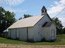
Old church building beside Route 95 in Drury, Missouri
Drury had a post office from 1893 until 2003 with zip code 65638.[2] The community has the name of the local Drury family.[3]
Drury is located on a ridge at approximate elevation of 1,215 feet (370 m) between south flowing tributary streams of Bryant Creek.[1]
References
- 1 2 3 Vanzant, Missouri, 7.5 Minute Topographic Quadrangle, USGS, 1973
- ↑ Post Offices in Douglas County, MO
- ↑ "Douglas County Place Names, 1928–1945 (archived)". The State Historical Society of Missouri. Archived from the original on 24 June 2016. Retrieved 28 September 2016.
Municipalities and communities of Douglas County, Missouri, United States | ||
|---|---|---|
| City | 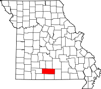 | |
| Townships |
| |
| Unincorporated communities | ||
| Ghost towns | ||
This article is issued from
Wikipedia.
The text is licensed under Creative Commons - Attribution - Sharealike.
Additional terms may apply for the media files.