Tigris, Missouri
| Tigris, Missouri | |
|---|---|
| Historic community | |
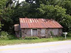 Old Store building on the south side of Route 14 at Tigris | |
 Tigris, Missouri Location of Tigris, Missouri | |
| Coordinates: 37°1′22″N 92°46′17″W / 37.02278°N 92.77139°WCoordinates: 37°1′22″N 92°46′17″W / 37.02278°N 92.77139°W[1] | |
| Country | U. S. A. |
| State | Missouri |
| County | Douglas County |
| Elevation[1] | 358 m (1,175 ft) |
| Time zone | UTC-6 (CST) |
| • Summer (DST) | UTC-5 (CDT) |
Tigris is an unincorporated community in western Douglas County, in the U.S. state of Missouri.[1] Tigris is located just west of the Beaver Creek bridge on Missouri Route 14.[2]
History
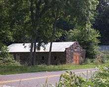
The old tomato canning factory/ garage along Route 14 at Tigris
A post office called Tigris was established in 1909, and remained in operation until 1926.[3] The community was named after the Tigris River, in Asia.[4]
References
- 1 2 3 U.S. Geological Survey Geographic Names Information System: Tigris, Missouri
- ↑ Missouri Atlas & Gazetteer, DeLorme, 1998, First edition, p. 62-63, ISBN 0-89933-224-2
- ↑ "Post Offices". Jim Forte Postal History. Retrieved 28 September 2016.
- ↑ "Douglas County Place Names, 1928–1945 (archived)". The State Historical Society of Missouri. Archived from the original on 24 June 2016. Retrieved 28 September 2016.
Municipalities and communities of Douglas County, Missouri, United States | ||
|---|---|---|
| City | 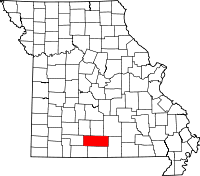 | |
| Townships |
| |
| Unincorporated communities | ||
| Ghost towns | ||
This article is issued from
Wikipedia.
The text is licensed under Creative Commons - Attribution - Sharealike.
Additional terms may apply for the media files.