Clay County, Tennessee
| Clay County, Tennessee | |
|---|---|
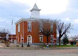 Clay County Courthouse in Celina | |
|
Location in the U.S. state of Tennessee | |
 Tennessee's location in the U.S. | |
| Founded | 1870 |
| Named for | Henry Clay[1] |
| Seat | Celina |
| Largest city | Celina |
| Area | |
| • Total | 259 sq mi (671 km2) |
| • Land | 237 sq mi (614 km2) |
| • Water | 23 sq mi (60 km2), 8.8% |
| Population | |
| • (2010) | 7,861 |
| • Density | 33/sq mi (13/km2) |
| Congressional district | 6th |
| Time zone | Central: UTC−6/−5 |
Clay County is a county located in the U.S. state of Tennessee. As of the 2010 census, the population was 7,861.[2] Its county seat and only incorporated city is Celina.[3] Clay County is named in honor of American statesman Henry Clay,[4] member of the United States Senate from Kentucky and United States Secretary of State in the 19th century. Its current mayor is Dale Reagan.
History
Clay County was formed in 1870 by combining pieces from surrounding Jackson and Overton counties.[5] Secretary of State Cordell Hull's first law office (now a museum) was located in Clay County.
Clay County's early inhabitants farmed and worked the Cumberland River, which was the major method of transportation in the Cumberland area. There were many docks and ferry crossings throughout Clay County to transport local crops and livestock to major markets. The timber industry was a major employer throughout the 1800s and 1900s and provides many jobs today. Tobacco farming became important in the local area throughout the 1900s and many old tobacco barns are still standing. With the end of government subsidies and with foreign competition, tobacco farming is minimal. Cattle and corn are the major agricultural influences today.
During the Civil War, many skirmishes took place up and down the Cumberland River to control the movement of barges laden with supplies. Local communities were split in their loyalties, with many families at odds with each other. Some of these animosities remain today between family groups.
The city of Celina is at the junction of the Obey and Cumberland rivers, and was a major port during the steamboat years between Nashville and Burnside, Kentucky. Although the Celina ferry landing no longer exists, Celina still connects the north and south by highway. Butler's Landing was used as a storage depot with large warehouses owned and operated by the Butler family. The first Clay County Court meeting was held in a store near the river at Butler's Landing on March 6, 1871. Butler's Landing nearly became the county seat, but Celina won the vote by a narrow margin.
Clay County's rural location and lack of major four-lane highway connections continues to hamper development and attraction of business and industry. This has resulted in the county having the highest unemployment rate in the state of Tennessee many months of the year and the loss of educated young people who have no opportunities locally. However, SR 52 is being upgraded to a 4-lane divided highway as part of the Corridor J project, which will connect to I-40 in Cookeville. .
Geography
According to the U.S. Census Bureau, the county has a total area of 259 square miles (670 km2), of which 237 square miles (610 km2) is land and 23 square miles (60 km2) (8.8%) is water.[6] The Cumberland River flows through the center of the county from north to south, fed by the Obey River which flows through the city of Celina from its impoundment at the Dale Hollow Reservoir. The reservoir, known as Dale Hollow Lake, inundates much of the eastern part of the county.
Adjacent counties
- Monroe County, Kentucky (north)
- Cumberland County, Kentucky (northeast)
- Clinton County, Kentucky (northeast)
- Pickett County (east)
- Overton County (southeast)
- Jackson County (south)
- Macon County (west)
State protected areas
- Standing Stone State Forest (part)
Demographics
| Historical population | |||
|---|---|---|---|
| Census | Pop. | %± | |
| 1880 | 6,987 | — | |
| 1890 | 7,260 | 3.9% | |
| 1900 | 8,421 | 16.0% | |
| 1910 | 9,009 | 7.0% | |
| 1920 | 9,193 | 2.0% | |
| 1930 | 9,577 | 4.2% | |
| 1940 | 10,904 | 13.9% | |
| 1950 | 8,701 | −20.2% | |
| 1960 | 7,289 | −16.2% | |
| 1970 | 6,624 | −9.1% | |
| 1980 | 7,676 | 15.9% | |
| 1990 | 7,238 | −5.7% | |
| 2000 | 7,976 | 10.2% | |
| 2010 | 7,861 | −1.4% | |
| Est. 2016 | 7,752 | [7] | −1.4% |
| U.S. Decennial Census[8] 1790-1960[9] 1900-1990[10] 1990-2000[11] 2010-2014[2] | |||
As of the census[13] of 2000, there were 7,976 people, 3,379 households, and 2,331 families residing in the county. The 2005 Census Estimate placed the population at 7,992 . The population density was 34 people per square mile (13/km²). There were 3,959 housing units at an average density of 17 per square mile (6/km²). The racial makeup of the county was 92.75% White, 1.44% Black or African American, 0.33% Native American, 0.14% Asian, 0.11% Pacific Islander, 0.24% from other races, and 4.99% from two or more races. 1.35% of the population were Hispanic or Latino of any race.
There were 3,379 households out of which 27.70% had children under the age of 18 living with them, 54.70% were married couples living together, 9.70% had a female householder with no husband present, and 31.00% were non-families. 27.60% of all households were made up of individuals and 12.00% had someone living alone who was 65 years of age or older. The average household size was 2.33 and the average family size was 2.80.
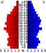
In the county, the population was spread out with 21.50% under the age of 18, 7.90% from 18 to 24, 27.40% from 25 to 44, 27.60% from 45 to 64, and 15.70% who were 65 years of age or older. The median age was 40 years. For every 100 females there were 94.60 males. For every 100 females age 18 and over, there were 95.00 males.
The median income for a household in the county was $23,958, and the median income for a family was $29,784. Males had a median income of $23,513 versus $16,219 for females. The per capita income for the county was $13,320. About 14.30% of families and 19.10% of the population were below the poverty line, including 23.40% of those under age 18 and 27.60% of those age 65 or over.
Communities
City
- Celina (county seat)
Unincorporated communities
- Arcot
- Beech Bethany
- Brimstone
- Butler's Landing
- Denton Crossroads
- Free Hill
- Hamilton Branch
- Hermitage Springs
- Lily Dale
- Maple Grove
- Moss
- Neely Crossroads
- Oak Grove
- Pea Ridge
- Shanky Branch
Politics
| Year | Republican | Democratic | Third Parties |
|---|---|---|---|
| 2016 | 73.3% 2,141 | 24.2% 707 | 2.5% 72 |
| 2012 | 62.0% 1,747 | 36.8% 1,037 | 1.3% 36 |
| 2008 | 56.0% 1,676 | 41.7% 1,248 | 2.3% 70 |
| 2004 | 49.2% 1,650 | 49.9% 1,675 | 1.0% 32 |
| 2000 | 42.7% 1,468 | 56.1% 1,931 | 1.3% 43 |
| 1996 | 36.9% 1,108 | 51.9% 1,559 | 11.3% 339 |
| 1992 | 33.2% 1,072 | 59.6% 1,922 | 7.2% 232 |
| 1988 | 51.8% 1,291 | 47.5% 1,183 | 0.8% 19 |
| 1984 | 50.8% 1,338 | 48.6% 1,281 | 0.6% 15 |
| 1980 | 48.6% 1,344 | 49.8% 1,376 | 1.6% 45 |
| 1976 | 36.7% 982 | 62.4% 1,671 | 0.9% 25 |
| 1972 | 59.0% 982 | 38.9% 648 | 2.0% 34 |
| 1968 | 42.1% 814 | 34.5% 667 | 23.3% 451 |
| 1964 | 34.2% 622 | 65.8% 1,196 | |
| 1960 | 52.1% 1,098 | 46.3% 976 | 1.5% 32 |
| 1956 | 48.3% 902 | 50.8% 948 | 0.9% 17 |
| 1952 | 46.2% 842 | 53.2% 968 | 0.6% 11 |
| 1948 | 37.0% 703 | 60.3% 1,146 | 2.7% 52 |
| 1944 | 46.3% 650 | 53.7% 754 | |
| 1940 | 29.4% 537 | 70.6% 1,288 | |
| 1936 | 35.7% 378 | 62.4% 661 | 1.9% 20 |
| 1932 | 30.2% 361 | 68.5% 819 | 1.3% 16 |
| 1928 | 49.0% 556 | 50.8% 576 | 0.3% 3 |
| 1924 | 41.7% 488 | 57.1% 668 | 1.3% 15 |
| 1920 | 57.1% 1,044 | 42.3% 772 | 0.6% 11 |
| 1916 | 45.0% 578 | 53.6% 689 | 1.4% 18 |
| 1912 | 35.1% 440 | 57.3% 718 | 7.6% 95 |
See also
References
- ↑ Origins Of Tennessee County Names, Tennessee Blue Book 2005-2006, pages 508-513.
- 1 2 "State & County QuickFacts". United States Census Bureau. Retrieved November 29, 2013.
- ↑ "Find a County". National Association of Counties. Archived from the original on 2011-05-31. Retrieved 2011-06-07.
- ↑ Gannett, Henry (1905). The Origin of Certain Place Names in the United States. Govt. Print. Off. p. 83.
- ↑ Corinne McLerran, "Clay County," Tennessee Encyclopedia of History and Culture. Retrieved: 24 June 2013.
- ↑ "2010 Census Gazetteer Files". United States Census Bureau. August 22, 2012. Retrieved April 2, 2015.
- ↑ "Population and Housing Unit Estimates". Retrieved June 9, 2017.
- ↑ "U.S. Decennial Census". United States Census Bureau. Archived from the original on May 12, 2015. Retrieved April 2, 2015.
- ↑ "Historical Census Browser". University of Virginia Library. Retrieved April 2, 2015.
- ↑ Forstall, Richard L., ed. (March 27, 1995). "Population of Counties by Decennial Census: 1900 to 1990". United States Census Bureau. Retrieved April 2, 2015.
- ↑ "Census 2000 PHC-T-4. Ranking Tables for Counties: 1990 and 2000" (PDF). United States Census Bureau. April 2, 2001. Retrieved April 2, 2015.
- ↑ Based on 2000 census data
- ↑ "American FactFinder". United States Census Bureau. Archived from the original on 2013-09-11. Retrieved 2011-05-14.
- ↑ Leip, David. "Dave Leip's Atlas of U.S. Presidential Elections". uselectionatlas.org. Retrieved 2018-03-10.
External links
| Wikimedia Commons has media related to Clay County, Tennessee. |
- Clay County Chamber of Commerce
- Clay County Schools
- Dale Hollow Lake tourism information
- Clay County, TNGenWeb - genealogy resources
- Dale Hollow Horizon – local newspaper
- Clay County at Curlie (based on DMOZ)
Places adjacent to Clay County, Tennessee | ||||||||||
|---|---|---|---|---|---|---|---|---|---|---|
| ||||||||||
Municipalities and communities of Clay County, Tennessee, United States | ||
|---|---|---|
| City | ||
| Unincorporated communities |
| |
