Chazay-d'Azergues
| Chazay-d’Azergues | ||
|---|---|---|
| Commune | ||
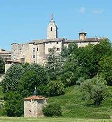 A view of the citadel of Chazay-d'Azergues | ||
| ||
 Chazay-d’Azergues Location within Auvergne-Rhône-Alpes region  Chazay-d’Azergues | ||
| Coordinates: 45°52′01″N 4°43′01″E / 45.867°N 4.717°ECoordinates: 45°52′01″N 4°43′01″E / 45.867°N 4.717°E | ||
| Country | France | |
| Region | Auvergne-Rhône-Alpes | |
| Department | Rhône | |
| Arrondissement | Villefranche-sur-Saône | |
| Canton | Anse | |
| Intercommunality | Communauté de communes Beaujolais-Pierres-Dorées | |
| Government | ||
| • Mayor (2014–2020) | Alain Martinet | |
| Area1 | 5.94 km2 (2.29 sq mi) | |
| Population (2012)2 | 3,943 | |
| • Density | 660/km2 (1,700/sq mi) | |
| Time zone | UTC+1 (CET) | |
| • Summer (DST) | UTC+2 (CEST) | |
| INSEE/Postal code | 69052 /69380 | |
| Elevation |
179–311 m (587–1,020 ft) (avg. 210 m or 690 ft) | |
| Website | www.chazaydazergues.fr | |
|
1 French Land Register data, which excludes lakes, ponds, glaciers > 1 km2 (0.386 sq mi or 247 acres) and river estuaries. 2 Population without double counting: residents of multiple communes (e.g., students and military personnel) only counted once. | ||
.svg.png)
Chazay-d'Azergues is a commune in the Rhône department in eastern France.
See also
References
| Wikimedia Commons has media related to Chazay-d'Azergues. |
This article is issued from
Wikipedia.
The text is licensed under Creative Commons - Attribution - Sharealike.
Additional terms may apply for the media files.