Cerisy-la-Forêt
| Cerisy-la-Forêt | |
|---|---|
| Commune | |
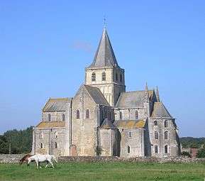 The abbey in Cerisy-la-Forêt | |
 Cerisy-la-Forêt Location within Normandy region  Cerisy-la-Forêt | |
| Coordinates: 49°11′45″N 0°56′08″W / 49.1958°N 0.9356°WCoordinates: 49°11′45″N 0°56′08″W / 49.1958°N 0.9356°W | |
| Country | France |
| Region | Normandy |
| Department | Manche |
| Arrondissement | Saint-Lô |
| Canton | Pont-Hébert |
| Intercommunality | Communauté de communes de l'Elle |
| Government | |
| • Mayor (2008–2014) | Jocelyne Le Trouit |
| Area1 | 23.81 km2 (9.19 sq mi) |
| Population (2006)2 | 900 |
| • Density | 38/km2 (98/sq mi) |
| Time zone | UTC+1 (CET) |
| • Summer (DST) | UTC+2 (CEST) |
| INSEE/Postal code | 50110 /50680 |
| Elevation |
34–131 m (112–430 ft) (avg. 84 m or 276 ft) |
|
1 French Land Register data, which excludes lakes, ponds, glaciers > 1 km2 (0.386 sq mi or 247 acres) and river estuaries. 2 Population without double counting: residents of multiple communes (e.g., students and military personnel) only counted once. | |
Cerisy-la-Forêt is a commune in the Manche department in Normandy in north-western France.
Geography
The commune is located in the department of Manche, north of the Armorican Massif, east of Pays saint-lois and west of Bessin. The village is located 13.4kilometers northeast of Saint-Lô overlooking the valley of the Elle, and offering an unobstructed panorama over the Cerisy Forest a kilometer away. The Massif Armoricain, of which Cerisy-la-Forêt occupies approximately the extreme north, is a country of dairy breeding. The semi-coconut landscapes are composed of meadows, hedges, wooded areas and wetlands.
Bayeux is 18 km east as the crow flies, Saint-Lô, prefecture of the department, 14 km to the south-west, and Caen 42 km to the east.[1]
Geology
The Armorican Massif, to the northeast of which extends the territory of Cerisy-la-Forêt, is a deposit made up of clays, schists, gravels, and granite. The altitude of the village is between about 34 m and approximately 131 m2. The highest point corresponds to the place called "Vieux Graviers" which is a small hill located at the edge of the territory of Cerisy-la-Forêt.
The basement of Cerisy-la-Forêt dates from the Proterozoic geological period.
Climate
The climate is oceanic. Annual rainfall is close to 900 mm.[2] Rains are fairly frequent throughout the year but more abundant in autumn and winter, in connection with disturbances from the Atlantic Ocean. Rarely intense, they often fall in the form of drizzle.
The average temperature is 10°C.[3] In winter, the average temperature oscillates between 1 °C and 7 °C. There are between 30 and 40 days of frost per year. In summer, the average temperature is around 20 °C.
Cerisy-la-Forêt does not have a weather station; the closest one is that of Caen-Carpiquet.
Name

The name derives from the Latin cerasus "cherry",[4] though Auguste Vincent holds it is named for a Gallo-Roman by the name Carisius or Charisius[5]
History
Ancient history
Cerisy was first settled as an oppidum the ruins of which remain outside the town.[6] The Romans built a fort to guard their Roman Road that ran through the valley.[7][8][9]
Middle Ages
The earliest mention Cerisy-la-Forêt dates back to the 6th century, when Gaul began to christianize. Vigor, one of the first evangelists in the region, received from Volusian the local lord twenty-five villages, to thank him for having rid the region of a "horrible serpent that put to death men and animals". So around 510AD he built a monastery dedicated to St. Peter and St. Paul on the site of what had been a Druid holy site.
In the 9th century, Neustria was invaded by the Vikings who in 891 plunder Bayeux, and Vigors monatry was destroyed. King Charles III the Simple gives Rollo the countries of Lower Seine in the treaty of Saint-Clair-sur Epte in 911, and then Bessin in 924.[10]
Cerisy is an important market town under the Normans, who build the Abbey of Saint-Vigor de Cerisy. The abbey will go to consist of forty-eight parishes and eight priories, including two in England (Sherborne and Peterborough). Depending on the Holy See, Cerisy maintained close relations with the monasteries of Mont-Saint-Michel, Saint-Ouen, Jumièges, Bec-Hellouin, Fécamp and of course Caen.
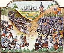
In 1337, the dynastic rivalries between the Valois and the king of England precipitated the Hundred Years War, which plunged the country into misery, aggravated by epidemics of plague. The Abbey of Saint-Vigor de Cerisy was is fortified and a garrison settles there. In 1418, Richard de Silly, knight and captain of the abbey, was obliged to cede the abbey to the King of England, however, after the victory of the constable de Richemont over the English at the Battle of Formigny in 1450, Normandy returned definitively to the kingdom of France.
Modern history
In 1660, a maréchaussée garrison was based in the village, and a prison established.[11]
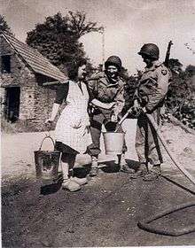
During the Second World War, Cerisy-la-Forêt sheltered refugees from Cherbourg.[12] On July 2, 1944, General Eisenhower and Omar Bradley came to encourage the 2nd American infantry division "Indian head" at the Château de la Boulaye.

On June 12, 1944, the 2nd American infantry division was ordered to cross the river. When the troops reached the east bank, they encountered an enemy resistance, which foreshadowed the end of the rapid advance begun on June 7, 1944. Despite the fact that it was a small easily crossed river, its crossing was difficult. A first attempt at crossing was stopped at the outset by a fire fueled by machine-guns and mortars from the west bank. On June 13, 1944, the men of Company C of the 38th Infantry Regiment were ordered to cross the river at this point. The first attempt in the morning failed and it was only in the afternoon after the second offensive that they succeeded in reaching the other bank.
The harshness of the fighting resulted in numerous casualties, 10 men of Company C were killed and 23 others wounded. In total, the losses of the 2nd American Infantry Division during these 2 days of combat amounted to 540 killed, wounded or disappeared.
During the second attack of Company C on June 13, 1944, the men were arrested by a fire fueled by machine guns. Enemy mortars began to adjust their fire on the GIs. Advancing under mortars, the men of the C Company advanced and won the battle.[13]
 Cerisy-la-foret rue halles (1920)
 Chateau de l'abbaye
 Cerisy-la-foret ecoles 1900
 Libération de cerisy nouveau
 Eugène godin.
Demographics
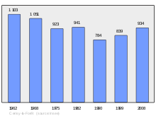
| Year | 1793 | 1800 | 1851 | 1901 | 1962 | 1968 | 1975 | 1982 | 1990 | 1999 | 2006 | 2011 | 2014 |
|---|---|---|---|---|---|---|---|---|---|---|---|---|---|
| Population | 2151 | 2105 | 1995 | 1510 | 1103 | 1 051 | 923 | 941 | 784 | 839 | 900 | 937 | 951 |
See also
References
- ↑ CERISY-LA-FORET Code INSEE - 50110 [archive], sur Géoportail, le portail des territoires et des citoyens (consulté le 26 mai 2012).
- ↑ https://web.archive.org/web/20110223121820/http://www.basse-normandie.ecologie.gouv.fr/iso_album/pluvio_inter_4.jpg
- ↑ http://www.meteofrance.com/accueil
- ↑ Auguste Longnon, Les noms de lieux de la France, Paris, 1920-1929; rééd. Champion, Paris, 1979, p. 625, § 2949.
- ↑ Auguste Vincent, Toponymie de la France, Bruxelles, 1937, p. 74b, § 180.
- ↑ L'oppidum de Saint-Jean-de-Savigny.
- ↑ Thomas Blanc-Dumont, Contribution à la caractérisation du type d’occupation des sols à partir des propriétés magnétiques : cas des sites de Montfarville et de Cerisy-la-Forêt (Basse Normandie)(Sous la direction de Marie Pétronille et Alain Tabbagh, 2006).
- ↑ Histoire de l'Académie royale des inscriptions et belles lettres, 28, (Paris, 1761) p480.
- ↑ Cerisy-la-Forêt - L'abbatiale.
- ↑ Abbaye de Cerisy [archive].
- ↑ Jean Bigot sieur de Sommesnil, État des paroisses des élections de Normandie, 1612/1636
- ↑ Ina » [archive].
- ↑ https://www.militarytimes.com/error-404.
| Wikimedia Commons has media related to Cerisy-la-Forêt. |