Audouville-la-Hubert
| Audouville-la-Hubert | |
|---|---|
| Commune | |
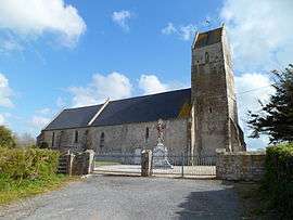 Sainte-Honorine church | |
 Audouville-la-Hubert Location within Normandy region  Audouville-la-Hubert | |
| Coordinates: 49°24′33″N 1°14′27″W / 49.4092°N 1.2408°WCoordinates: 49°24′33″N 1°14′27″W / 49.4092°N 1.2408°W | |
| Country | France |
| Region | Normandy |
| Department | Manche |
| Arrondissement | Cherbourg |
| Canton | Carentan |
| Intercommunality | CC Baie Cotentin |
| Government | |
| • Mayor (2014-2020) | Pascal Leconte |
| Area1 | 6.40 km2 (2.47 sq mi) |
| Population (2015)2 | 80 |
| • Density | 13/km2 (32/sq mi) |
| Time zone | UTC+1 (CET) |
| • Summer (DST) | UTC+2 (CEST) |
| INSEE/Postal code | 50021 /50480 |
| Elevation | 1–22 m (3.3–72.2 ft) |
|
1 French Land Register data, which excludes lakes, ponds, glaciers > 1 km2 (0.386 sq mi or 247 acres) and river estuaries. 2 Population without double counting: residents of multiple communes (e.g., students and military personnel) only counted once. | |
Audouville-la-Hubert is a commune in the Manche department in the Normandy region in northwestern France.
History
Audouville La Hubert was the scene of a mass murder of 30 disarmed German POWs by American paratroopers in 1944 during the Battle of Normandy.[1]
Population
| Historical population | ||
|---|---|---|
| Year | Pop. | ±% |
| 1793 | 226 | — |
| 1800 | 236 | +4.4% |
| 1806 | 248 | +5.1% |
| 1821 | 249 | +0.4% |
| 1831 | 259 | +4.0% |
| 1836 | 301 | +16.2% |
| 1841 | 305 | +1.3% |
| 1846 | 245 | −19.7% |
| 1851 | 242 | −1.2% |
| 1856 | 197 | −18.6% |
| 1861 | 212 | +7.6% |
| 1866 | 217 | +2.4% |
| 1872 | 210 | −3.2% |
| 1876 | 214 | +1.9% |
| 1881 | 200 | −6.5% |
| 1886 | 196 | −2.0% |
| 1891 | 188 | −4.1% |
| 1896 | 176 | −6.4% |
| 1901 | 169 | −4.0% |
| 1906 | 165 | −2.4% |
| 1911 | 192 | +16.4% |
| 1921 | 162 | −15.6% |
| 1926 | 163 | +0.6% |
| 1931 | 165 | +1.2% |
| 1936 | 154 | −6.7% |
| 1946 | 138 | −10.4% |
| 1954 | 135 | −2.2% |
| 1962 | 161 | +19.3% |
| 1968 | 128 | −20.5% |
| 1975 | 129 | +0.8% |
| 1982 | 93 | −27.9% |
| 1990 | 97 | +4.3% |
| 1999 | 83 | −14.4% |
| 2006 | 73 | −12.0% |
| 2009 | 57 | −21.9% |
| 2015 | 80 | +40.4% |
See also
References
- ↑ Wiegrefe, Klaus (4 May 2010). "The Horror of D-Day: A New Openness to Discussing Allied War Crimes in WWII". Der Spiegel. Spiegel-Verlag. Retrieved 19 March 2017.
| Wikimedia Commons has media related to Audouville-la-Hubert. |
This article is issued from
Wikipedia.
The text is licensed under Creative Commons - Attribution - Sharealike.
Additional terms may apply for the media files.