Quettehou
| Quettehou | ||
|---|---|---|
| Commune | ||
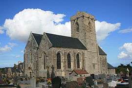 The church of Saint-Vigor | ||
| ||
 Quettehou Location within Normandy region  Quettehou | ||
| Coordinates: 49°35′36″N 1°18′09″W / 49.5933°N 1.3025°WCoordinates: 49°35′36″N 1°18′09″W / 49.5933°N 1.3025°W | ||
| Country | France | |
| Region | Normandy | |
| Department | Manche | |
| Arrondissement | Cherbourg | |
| Canton | Val-de-Saire | |
| Intercommunality | CA Cotentin | |
| Government | ||
| • Mayor (2008–2014) | Jean-Pierre Lemyre | |
| Area1 | 16.17 km2 (6.24 sq mi) | |
| Population (2006)2 | 1,544 | |
| • Density | 95/km2 (250/sq mi) | |
| Time zone | UTC+1 (CET) | |
| • Summer (DST) | UTC+2 (CEST) | |
| INSEE/Postal code | 50417 /50630 | |
| Elevation |
1–104 m (3.3–341.2 ft) (avg. 10 m or 33 ft) | |
|
1 French Land Register data, which excludes lakes, ponds, glaciers > 1 km2 (0.386 sq mi or 247 acres) and river estuaries. 2 Population without double counting: residents of multiple communes (e.g., students and military personnel) only counted once. | ||
.svg.png)
Quettehou is a commune in the Manche department in north-western France.
Geography
The town of Quettehou is located at the North-East tip of the peninsula of Cotentin in an area called Val de Saire, the vale of the river Saire.
History
The creation of Quettehou dates back to the Viking invasions when Ketil, chief of a Viking tribe, decided to settle at the top of the hill dominating the bay of Morsalines. With time, Ketil's hill (Ketil holm) became known as Quettehou.
The Black Prince was knighted in the local church by his father, King Edward III of England on July 12th, 1346 prior to the Battle of Crécy.[1]
See also
References
External links
| Wikimedia Commons has media related to Quettehou. |
- Local site about Quettehou and its surroundings (in French & English)
This article is issued from
Wikipedia.
The text is licensed under Creative Commons - Attribution - Sharealike.
Additional terms may apply for the media files.