Fleury, Manche
| Fleury | |
|---|---|
| Commune | |
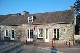 Town hall | |
 Fleury Location within Normandy region  Fleury | |
| Coordinates: 48°50′55″N 1°16′28″W / 48.8486°N 1.2744°WCoordinates: 48°50′55″N 1°16′28″W / 48.8486°N 1.2744°W | |
| Country | France |
| Region | Normandy |
| Department | Manche |
| Arrondissement | Saint-Lô |
| Canton | Villedieu-les-Poêles |
| Intercommunality | Communauté de communes du canton de Villedieu-les-Poêles |
| Government | |
| • Mayor (2008–2014) | Patrick Challier |
| Area1 | 12.60 km2 (4.86 sq mi) |
| Population (2006)2 | 847 |
| • Density | 67/km2 (170/sq mi) |
| Demonym(s) | Fleurions |
| Time zone | UTC+1 (CET) |
| • Summer (DST) | UTC+2 (CEST) |
| INSEE/Postal code | 50185 /50800 |
| Elevation |
109–201 m (358–659 ft) (avg. 150 m or 490 ft) |
|
1 French Land Register data, which excludes lakes, ponds, glaciers > 1 km2 (0.386 sq mi or 247 acres) and river estuaries. 2 Population without double counting: residents of multiple communes (e.g., students and military personnel) only counted once. | |
Fleury is a commune in the Manche department in north-western France.
Notable residents
Gallery
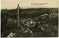 Ruins of Fleury after World War I
See also
| Wikimedia Commons has media related to Fleury (Manche). |
This article is issued from
Wikipedia.
The text is licensed under Creative Commons - Attribution - Sharealike.
Additional terms may apply for the media files.