Raids
| Raids | |
|---|---|
| Commune | |
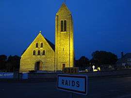 The church of Saint-Georges | |
 Raids Location within Normandy region  Raids | |
| Coordinates: 49°13′04″N 1°20′34″W / 49.2178°N 1.3428°WCoordinates: 49°13′04″N 1°20′34″W / 49.2178°N 1.3428°W | |
| Country | France |
| Region | Normandy |
| Department | Manche |
| Arrondissement | Coutances |
| Canton | Agon-Coutainville |
| Government | |
| • Mayor (2008–2014) | Jean-Claude Boscher |
| Area1 | 6.80 km2 (2.63 sq mi) |
| Population (2006)2 | 202 |
| • Density | 30/km2 (77/sq mi) |
| Time zone | UTC+1 (CET) |
| • Summer (DST) | UTC+2 (CEST) |
| INSEE/Postal code | 50422 /50500 |
| Elevation |
2–19 m (6.6–62.3 ft) (avg. 12 m or 39 ft) |
|
1 French Land Register data, which excludes lakes, ponds, glaciers > 1 km2 (0.386 sq mi or 247 acres) and river estuaries. 2 Population without double counting: residents of multiple communes (e.g., students and military personnel) only counted once. | |
Raids is a commune in the Manche department in north-western France.
See also
| Wikimedia Commons has media related to Raids. |
This article is issued from
Wikipedia.
The text is licensed under Creative Commons - Attribution - Sharealike.
Additional terms may apply for the media files.