Gatteville-le-Phare
| Gatteville-le-Phare | ||
|---|---|---|
| Commune | ||
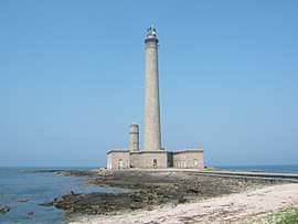 The Gatteville lighthouse | ||
| ||
 Gatteville-le-Phare Location within Normandy region  Gatteville-le-Phare | ||
| Coordinates: 49°41′13″N 1°16′56″W / 49.6869°N 1.2822°WCoordinates: 49°41′13″N 1°16′56″W / 49.6869°N 1.2822°W | ||
| Country | France | |
| Region | Normandy | |
| Department | Manche | |
| Arrondissement | Cherbourg | |
| Canton | Val-de-Saire | |
| Intercommunality | CA Cotentin | |
| Government | ||
| • Mayor (2008–2014) | Christine Léonard | |
| Area1 | 9.70 km2 (3.75 sq mi) | |
| Population (2006)2 | 516 | |
| • Density | 53/km2 (140/sq mi) | |
| Demonym(s) | Gattevillais | |
| Time zone | UTC+1 (CET) | |
| • Summer (DST) | UTC+2 (CEST) | |
| INSEE/Postal code | 50196 /50760 | |
| Elevation | 0–36 m (0–118 ft) | |
|
1 French Land Register data, which excludes lakes, ponds, glaciers > 1 km2 (0.386 sq mi or 247 acres) and river estuaries. 2 Population without double counting: residents of multiple communes (e.g., students and military personnel) only counted once. | ||
.svg.png)
Gatteville-le-Phare is a commune in the Manche department in north-western France.
See also
- Communes of the Manche department
- Antipodes Islands, the exact antipodes of Gatteville-le-Phare
| Wikimedia Commons has media related to Gatteville-le-Phare. |
This article is issued from
Wikipedia.
The text is licensed under Creative Commons - Attribution - Sharealike.
Additional terms may apply for the media files.