Barfleur
| Barfleur | ||
|---|---|---|
| Commune | ||
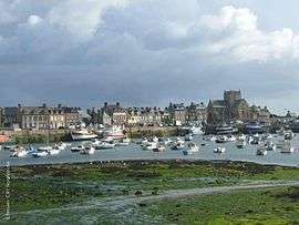 The harbour in Barfleur | ||
| ||
 Barfleur Location within Normandy region  Barfleur | ||
| Coordinates: 49°40′16″N 1°15′48″W / 49.6711°N 1.2633°WCoordinates: 49°40′16″N 1°15′48″W / 49.6711°N 1.2633°W | ||
| Country | France | |
| Region | Normandy | |
| Department | Manche | |
| Arrondissement | Cherbourg | |
| Canton | Val-de-Saire | |
| Intercommunality | CA Cotentin | |
| Government | ||
| • Mayor (2008–2014) | Jean Deville | |
| Area1 | 0.6 km2 (0.2 sq mi) | |
| Population (2009)2 | 648 | |
| • Density | 1,100/km2 (2,800/sq mi) | |
| Time zone | UTC+1 (CET) | |
| • Summer (DST) | UTC+2 (CEST) | |
| INSEE/Postal code | 50030 /50760 | |
|
1 French Land Register data, which excludes lakes, ponds, glaciers > 1 km2 (0.386 sq mi or 247 acres) and river estuaries. 2 Population without double counting: residents of multiple communes (e.g., students and military personnel) only counted once. | ||
Barfleur is a commune in the Manche department in the Normandy region in northwestern France. It is twinned with Lyme Regis in the United Kingdom.
History
Middle Ages
In the Middle Ages Barfleur was one of the chief ports of embarkation for England.[1]
- 1066 - A large medallion fixed to a rock in the harbour marks the Norman departure from Barfleur before the Battle of Hastings.
- 1120 - The White Ship, carrying Prince William, only legitimate son of Henry I of England, went down outside the harbour,[1] setting the stage for the period of civil war in England known as the Anarchy.
- 1194 - Richard I of England departed from Barfleur on return to England following his captivity by Henry VI, Holy Roman Emperor.
Later
Population
| Historical population | ||
|---|---|---|
| Year | Pop. | ±% |
| 1793 | 896 | — |
| 1800 | 899 | +0.3% |
| 1806 | 2,553 | +184.0% |
| 1821 | 2,674 | +4.7% |
| 1831 | 2,675 | +0.0% |
| 1836 | 1,158 | −56.7% |
| 1841 | 1,185 | +2.3% |
| 1846 | 1,195 | +0.8% |
| 1851 | 1,271 | +6.4% |
| 1856 | 1,279 | +0.6% |
| 1861 | 1,304 | +2.0% |
| 1866 | 1,253 | −3.9% |
| 1872 | 1,218 | −2.8% |
| 1876 | 1,070 | −12.2% |
| 1881 | 1,005 | −6.1% |
| 1886 | 1,065 | +6.0% |
| 1891 | 1,135 | +6.6% |
| 1896 | 1,189 | +4.8% |
| 1901 | 1,210 | +1.8% |
| 1906 | 1,274 | +5.3% |
| 1911 | 1,238 | −2.8% |
| 1921 | 1,116 | −9.9% |
| 1926 | 1,100 | −1.4% |
| 1931 | 1,069 | −2.8% |
| 1936 | 1,065 | −0.4% |
| 1946 | 977 | −8.3% |
| 1954 | 907 | −7.2% |
| 1962 | 847 | −6.6% |
| 1968 | 837 | −1.2% |
| 1975 | 703 | −16.0% |
| 1982 | 619 | −11.9% |
| 1990 | 599 | −3.2% |
| 1999 | 642 | +7.2% |
| 2006 | 650 | +1.2% |
| 2009 | 648 | −0.3% |
Heraldry
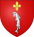 |
The arms of Barfleur are blazoned : Gules, a seabass contourny palewise argent, and in chief a fleur de lys Or. (seabass=bar en français) type "rébus"= bar=seabass + Fleur=flower (but the name Barfleur is actually of scandinavian origin : Barbefloth, Barba's river). |
Geography
About 2 miles (3.2 km) to the north is Cape Barfleur, with a lighthouse 233 ft (71 m) high.[1]
Transportation
A Brittany Ferries vessel is named after the village and operates from nearby Cherbourg-Octeville to Poole in the United Kingdom.
See also
Notes
- 1 2 3

References
External links
| Wikimedia Commons has media related to Barfleur. |
- Barfleur official website (in French)
- Life of Gilles le Marchant de Raffoville, corsair who died in Barfleur
This article is issued from
Wikipedia.
The text is licensed under Creative Commons - Attribution - Sharealike.
Additional terms may apply for the media files.