La Haye-Pesnel
| La Haye-Pesnel | ||
|---|---|---|
| Commune | ||
 The town hall in La Haye-Pesnel | ||
| ||
 La Haye-Pesnel Location within Normandy region  La Haye-Pesnel | ||
| Coordinates: 48°47′47″N 1°23′44″W / 48.7964°N 1.3956°WCoordinates: 48°47′47″N 1°23′44″W / 48.7964°N 1.3956°W | ||
| Country | France | |
| Region | Normandy | |
| Department | Manche | |
| Arrondissement | Avranches | |
| Canton | Bréhal | |
| Intercommunality | Communauté de communes du Pays hayland | |
| Government | ||
| • Mayor (2008–2014) | Robert Levivier | |
| Area1 | 6.29 km2 (2.43 sq mi) | |
| Population (2006)2 | 1,365 | |
| • Density | 220/km2 (560/sq mi) | |
| Time zone | UTC+1 (CET) | |
| • Summer (DST) | UTC+2 (CEST) | |
| INSEE/Postal code | 50237 /50320 | |
| Elevation |
62–134 m (203–440 ft) (avg. 89 m or 292 ft) | |
|
1 French Land Register data, which excludes lakes, ponds, glaciers > 1 km2 (0.386 sq mi or 247 acres) and river estuaries. 2 Population without double counting: residents of multiple communes (e.g., students and military personnel) only counted once. | ||
La Haye-Pesnel is a commune in the Manche department in Normandy in north-western France.
Heraldry
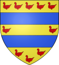 |
The arms of La Haye-Pesnel are blazoned : Or, 2 fesses azure, between 10 martlets in orle gules. |
See also
| Wikimedia Commons has media related to La Haye-Pesnel. |
This article is issued from
Wikipedia.
The text is licensed under Creative Commons - Attribution - Sharealike.
Additional terms may apply for the media files.