Saint-Brice-de-Landelles
| Saint-Brice-de-Landelles | |
|---|---|
| Commune | |
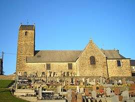 The church of Saint-Brice | |
 Saint-Brice-de-Landelles Location within Normandy region  Saint-Brice-de-Landelles | |
| Coordinates: 48°32′04″N 1°09′05″W / 48.5344°N 1.1514°WCoordinates: 48°32′04″N 1°09′05″W / 48.5344°N 1.1514°W | |
| Country | France |
| Region | Normandy |
| Department | Manche |
| Arrondissement | Avranches |
| Canton | Saint-Hilaire-du-Harcouët |
| Intercommunality | Saint-Hilaire-du-Harcouët |
| Government | |
| • Mayor (2008–2014) | Émilien Bertin |
| Area1 | 14.77 km2 (5.70 sq mi) |
| Population (1999)2 | 616 |
| • Density | 42/km2 (110/sq mi) |
| Time zone | UTC+1 (CET) |
| • Summer (DST) | UTC+2 (CEST) |
| INSEE/Postal code | 50452 /50730 |
| Elevation |
59–202 m (194–663 ft) (avg. 185 m or 607 ft) |
|
1 French Land Register data, which excludes lakes, ponds, glaciers > 1 km2 (0.386 sq mi or 247 acres) and river estuaries. 2 Population without double counting: residents of multiple communes (e.g., students and military personnel) only counted once. | |
Saint-Brice-de-Landelles is a commune in the Manche department in Normandy in north-western France.
See also
References
| Wikimedia Commons has media related to Saint-Brice-de-Landelles. |
This article is issued from
Wikipedia.
The text is licensed under Creative Commons - Attribution - Sharealike.
Additional terms may apply for the media files.