Saint-Cyr-du-Bailleul
| Saint-Cyr-du-Bailleul | |
|---|---|
| Commune | |
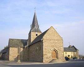 The church of Saint-Cyr-et-Sainte-Julitte | |
 Saint-Cyr-du-Bailleul Location within Normandy region  Saint-Cyr-du-Bailleul | |
| Coordinates: 48°34′00″N 0°47′56″W / 48.5667°N 0.7989°WCoordinates: 48°34′00″N 0°47′56″W / 48.5667°N 0.7989°W | |
| Country | France |
| Region | Normandy |
| Department | Manche |
| Arrondissement | Avranches |
| Canton | Le Mortainais |
| Intercommunality | Sélune |
| Government | |
| • Mayor (2008–2014) | Claudine Sauvé |
| Area1 | 23.41 km2 (9.04 sq mi) |
| Population (1999)2 | 444 |
| • Density | 19/km2 (49/sq mi) |
| Time zone | UTC+1 (CET) |
| • Summer (DST) | UTC+2 (CEST) |
| INSEE/Postal code | 50462 /50720 |
| Elevation |
92–226 m (302–741 ft) (avg. 62 m or 203 ft) |
|
1 French Land Register data, which excludes lakes, ponds, glaciers > 1 km2 (0.386 sq mi or 247 acres) and river estuaries. 2 Population without double counting: residents of multiple communes (e.g., students and military personnel) only counted once. | |
Saint-Cyr-du-Bailleul is a commune in the Manche department in Normandy in northwestern France.
See also
References
| Wikimedia Commons has media related to Saint-Cyr-du-Bailleul. |
This article is issued from
Wikipedia.
The text is licensed under Creative Commons - Attribution - Sharealike.
Additional terms may apply for the media files.