Les Loges-Marchis
| Les Loges-Marchis | |
|---|---|
| Commune | |
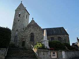 The church of Saint-Pierre-et-Saint-Paul | |
 Les Loges-Marchis Location within Normandy region  Les Loges-Marchis | |
| Coordinates: 48°32′34″N 1°05′13″W / 48.5428°N 1.0869°WCoordinates: 48°32′34″N 1°05′13″W / 48.5428°N 1.0869°W | |
| Country | France |
| Region | Normandy |
| Department | Manche |
| Arrondissement | Avranches |
| Canton | Saint-Hilaire-du-Harcouët |
| Intercommunality | Communauté de communes de Saint-Hilaire-du-Harcouët |
| Government | |
| • Mayor (2008–2014) | Paulette Matéo |
| Area1 | 19.78 km2 (7.64 sq mi) |
| Population (2006)2 | 1,018 |
| • Density | 51/km2 (130/sq mi) |
| Time zone | UTC+1 (CET) |
| • Summer (DST) | UTC+2 (CEST) |
| INSEE/Postal code | 50274 /50600 |
| Elevation |
69–208 m (226–682 ft) (avg. 175 m or 574 ft) |
|
1 French Land Register data, which excludes lakes, ponds, glaciers > 1 km2 (0.386 sq mi or 247 acres) and river estuaries. 2 Population without double counting: residents of multiple communes (e.g., students and military personnel) only counted once. | |
Les Loges-Marchis is a commune in the Manche department in Normandy in north-western France.
History The village was badly affected by the French Dysentery Epidemic of 1779 such that 250 died and the graveyard had to be extended this may be the origin of the five crosses (Les Cinq Croix)
See also
| Wikimedia Commons has media related to Les Loges-Marchis. |
This article is issued from
Wikipedia.
The text is licensed under Creative Commons - Attribution - Sharealike.
Additional terms may apply for the media files.