Le Luot
| Le Luot | |
|---|---|
| Commune | |
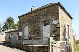 Town hall | |
 Le Luot Location within Normandy region  Le Luot | |
| Coordinates: 48°45′27″N 1°19′06″W / 48.7575°N 1.3183°WCoordinates: 48°45′27″N 1°19′06″W / 48.7575°N 1.3183°W | |
| Country | France |
| Region | Normandy |
| Department | Manche |
| Arrondissement | Avranches |
| Canton | Bréhal |
| Intercommunality | Pays hayland |
| Government | |
| • Mayor (2008–2014) | Roland Josseaume |
| Area1 | 8.50 km2 (3.28 sq mi) |
| Population (2006)2 | 208 |
| • Density | 24/km2 (63/sq mi) |
| Time zone | UTC+1 (CET) |
| • Summer (DST) | UTC+2 (CEST) |
| INSEE/Postal code | 50282 /50870 |
| Elevation |
80–182 m (262–597 ft) (avg. 136 m or 446 ft) |
|
1 French Land Register data, which excludes lakes, ponds, glaciers > 1 km2 (0.386 sq mi or 247 acres) and river estuaries. 2 Population without double counting: residents of multiple communes (e.g., students and military personnel) only counted once. | |
Le Luot is a commune in the Manche department in Normandy in north-western France.
See also
| Wikimedia Commons has media related to Le Luot. |
This article is issued from
Wikipedia.
The text is licensed under Creative Commons - Attribution - Sharealike.
Additional terms may apply for the media files.