Pirou
| Pirou | ||
|---|---|---|
| Commune | ||
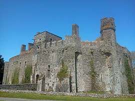 The chateau | ||
| ||
 Pirou Location within Normandy region  Pirou | ||
| Coordinates: 49°10′00″N 1°34′04″W / 49.1667°N 1.5678°WCoordinates: 49°10′00″N 1°34′04″W / 49.1667°N 1.5678°W | ||
| Country | France | |
| Region | Normandy | |
| Department | Manche | |
| Arrondissement | Coutances | |
| Canton | Créances | |
| Government | ||
| • Mayor (2008–2014) | Noël Augrandjean | |
| Area1 | 29.11 km2 (11.24 sq mi) | |
| Population (2006)2 | 1,563 | |
| • Density | 54/km2 (140/sq mi) | |
| Time zone | UTC+1 (CET) | |
| • Summer (DST) | UTC+2 (CEST) | |
| INSEE/Postal code | 50403 /50770 | |
| Elevation |
0–40 m (0–131 ft) (avg. 10 m or 33 ft) | |
|
1 French Land Register data, which excludes lakes, ponds, glaciers > 1 km2 (0.386 sq mi or 247 acres) and river estuaries. 2 Population without double counting: residents of multiple communes (e.g., students and military personnel) only counted once. | ||
Pirou is a commune in the Manche department in Normandy in north-western France. It is around 50 km south of Cherbourg and 90 km west of Caen. The inhabitants are called Pirouais.
Heraldry
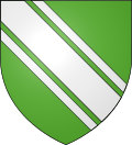 |
The arms of Pirou are blazoned: Vert, a bend cotissed argent.
|
See also
- Communes of the Manche department
- Château de Pirou
- Wild at art - photo log of the famous graffiti in the abandoned village
| Wikimedia Commons has media related to Pirou. |
This article is issued from
Wikipedia.
The text is licensed under Creative Commons - Attribution - Sharealike.
Additional terms may apply for the media files.